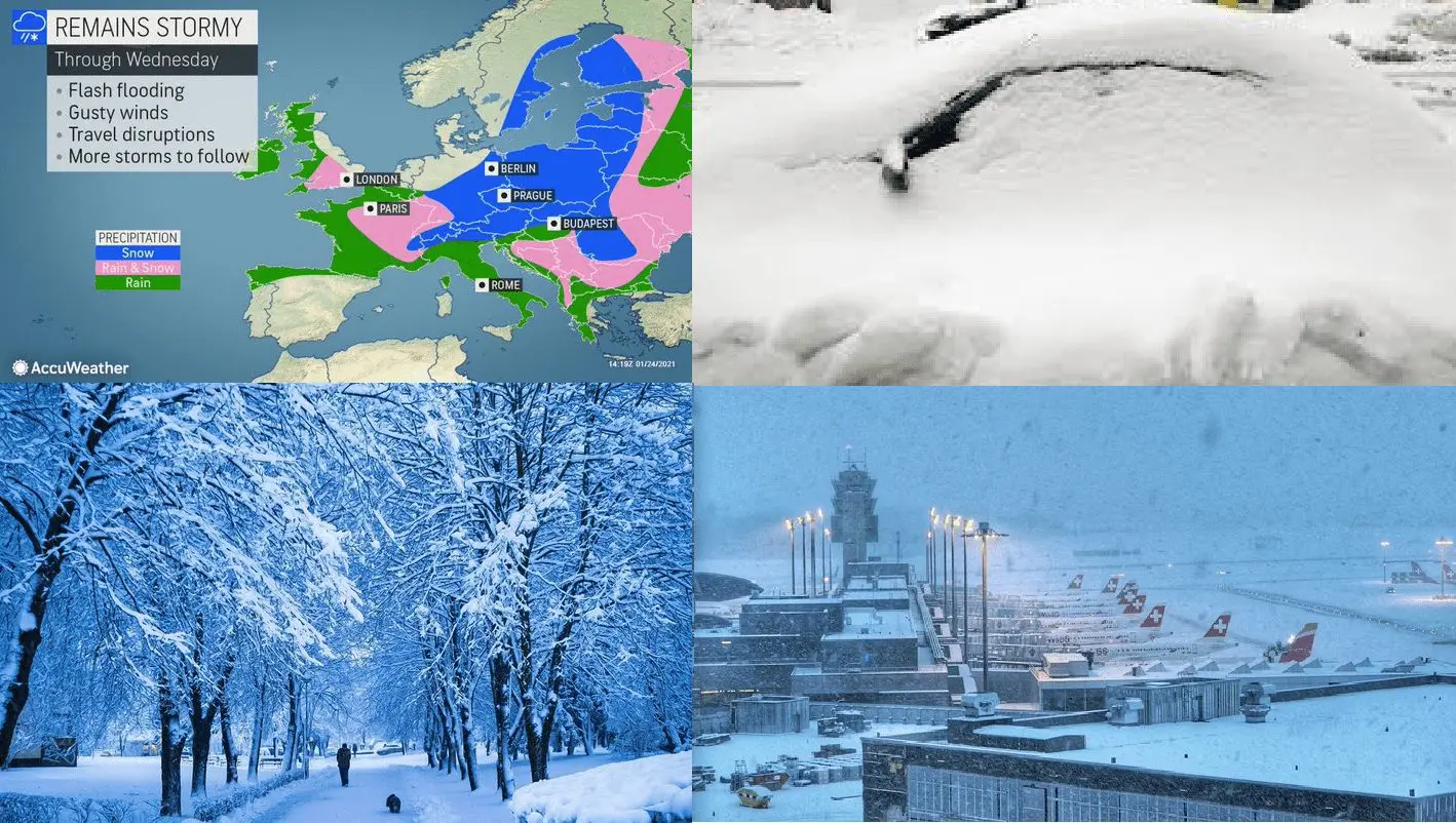
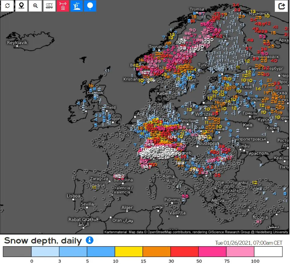
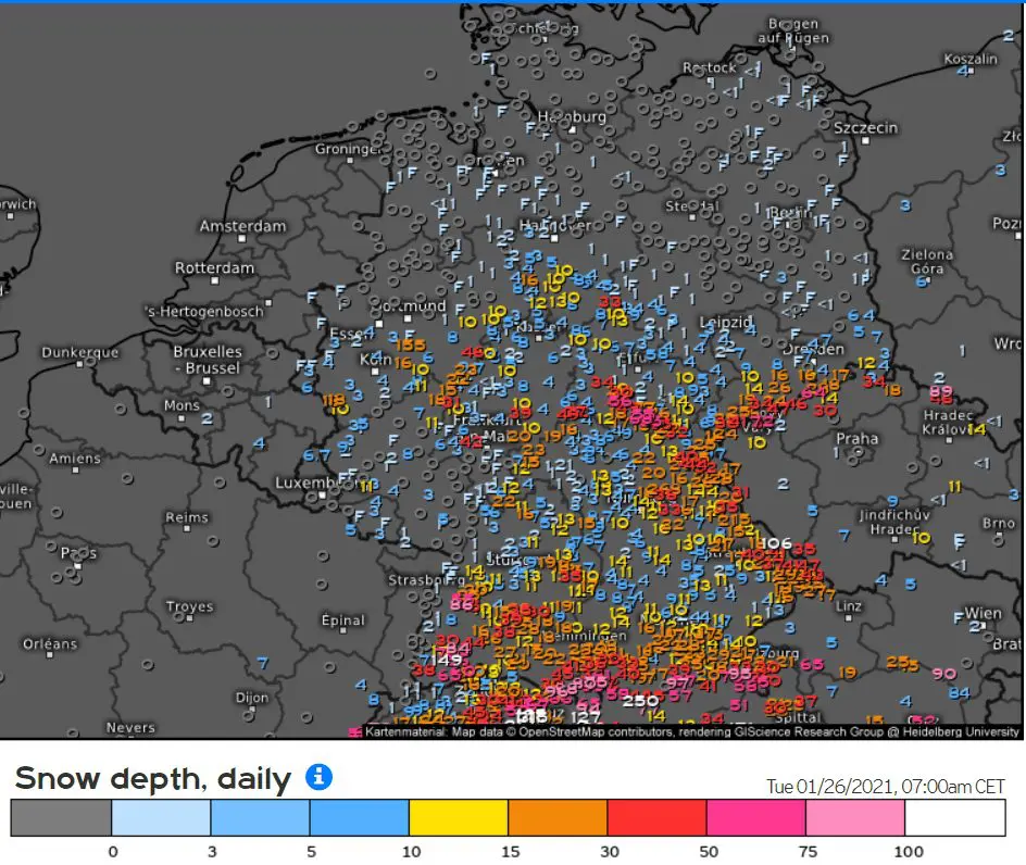
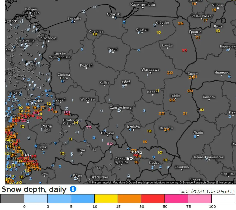
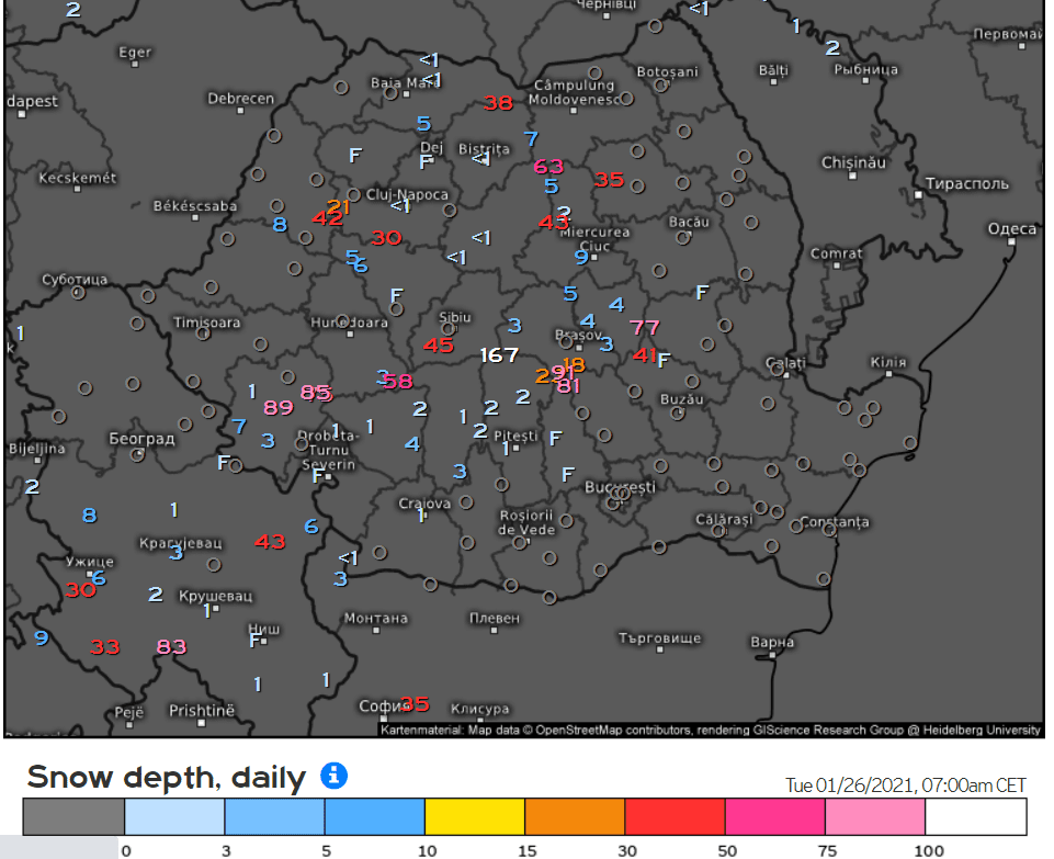
Part of polar vortex above Europe is bringing lot of precipitation to many parts of continent. From Central Europe, Baltic region and Scandinavia is reported of expected mainly snowing
Mainly in southern half of Germany, parts of Switzerland, Austria, eastern Slovakia, Carpathian Romania, eastern Poland, Baltic states, Scandinavia and western Ukraine and Belarus is ongoing regional (but not so much extreme) snow calamity
In lower situated basins and lowlands in mentioned regions is regionally 15 – 30 cm of snow, rarely above 0,5 meters Scandinavia even 1 – 1,5 meters
Many airports report problems, some busy highways are more dangerous, some mountain passages closed.
In last days, snowing surprised London or Paris -20/-25°C interval in basins and valleys in Central Europe around 1. Feburary 2021
Information about third , possibly extremely storng attack of winter in the second February pentade , should be with relative high probability confirmed or denied already until the end of current week .
Infographics: meteologix.com, AccuWeather, Twitter
Read more:
https://mkweather.com/2021/01/26/the-most-extreme-forecast-of-the-year-should-be-winter-even-stronger-30c-in-central-europe-again/
https://mkweather.com/2021/01/25/170-km-h-storm-swept-through-mallorca-many-damages/
https://mkweather.com/2021/01/25/extreme-storms-and-floods-hit-belo-horizonte-sao-paulo-brazil/
https://mkweather.com/2021/01/25/australia-with-extreme-heatwave-and-wildfires-port-augusta-near-adelaide-453celsius/
https://mkweather.com/2021/01/25/the-2nd-and-3rd-peak-20-25c-in-central-europe-and-40-45c-in-scandinavia/
https://mkweather.com/2021/01/24/the-second-peak-is-here-the-heaviest-snowing-in-london-for-3-years-2021/
https://mkweather.com/2021/01/24/peak-of-winter-in-turkey-agri-345celsius/
https://mkweather.com/2021/01/24/frozen-animals-mongolia-480c-and-kazakhstan-404c-with-one-of-the-most-extreme-winters-on-record/
https://mkweather.com/2021/01/24/antarctica-set-to-coldest-january-since-1978-southern-hemisphere-hasnt-been-so-cold-almost-10-years/
https://mkweather.com/2021/01/24/tropical-activity-forecast-for-next-month-and-half-year-videos-ts-eloise-kimi-chalane-imogen-danilo/
https://mkweather.com/2021/01/24/peak-of-winter-in-turkey-agri-345celsius/
https://mkweather.com/2021/01/24/chile-with-widespread-wildfires-chillan-6-days-with-34-36c/
https://mkweather.com/2021/01/24/extreme-hailstorms-hit-argentina-patagonia-with-all-time-record-438c/
https://mkweather.com/2021/01/23/adriatic-low-in-poland-and-slovakia-should-bring-snow-calamity-and-regionally-20-50-cm-of-snowfall-mk/
https://mkweather.com/2021/01/21/siberia-the-strongest-frosts-since-1996-up-to-584celsius/
https://mkweather.com/2021/01/21/big-agricultural-forecast-for-the-world-2021-weather-patterns-nao-signals-and-enso-signals-mk-2021/
https://mkweather.com/2021/01/21/turkey-32c-ukraine-30c-frosts-have-shifted-eastward/
https://mkweather.com/2021/01/21/southwest-usa-after-35c-94f-and-wildfires-a-powerful-coldwave-early-next-week-2021/
https://mkweather.com/2021/01/18/siberia-with-the-3rd-strongest-coldwave-since-2000-delyankir-581c-verkhoyansk-578c/
https://mkweather.com/2021/01/19/surprising-night-in-poland-biebrzy-297c/
https://mkweather.com/2021/01/19/romania-232c-and-bears-climbing-on-the-gate-serbia-189c-plitvice-waterfalls-in-croatia-frozen-winter-in-balkan-2021/
https://mkweather.com/2021/01/18/orlicke-zahori-czechia-on-the-polish-border-270celsius-2021/
https://mkweather.com/2021/01/18/the-strongest-frosts-in-poland-since-2010-goldapi-278c-report-from-sztabin-30c-2021/
https://mkweather.com/2021/01/18/slovakia-250celsius-the-strongest-frosts-since-legendary-2017/
https://mkweather.com/2021/01/18/in-bandon-near-balaton-in-hungary-was-measured-204celsius/
https://mkweather.com/2021/01/18/kozani-greece-193c-snow-in-istanbul-and-30c-forecast-for-turkey/
https://mkweather.com/2021/01/17/a-big-comeback-of-cruel-winter-30celsius-around-1-february-2021-the-second-peak-is-confirming-2021/
https://mkweather.com/2021/01/17/jelgava-latvia-310c-tied-daily-record-from-cruel-winter-1940/
https://mkweather.com/2021/01/17/belarus-287c-lithuania-275c-estonia-251celsius-next-night-will-be-deadly/
https://mkweather.com/2021/01/16/helsinki-61-cm-of-snow-n-e-finland-up-to-40celsius-extreme-snow-frosts/
https://mkweather.com/2021/01/16/france-under-the-snow-orange-warnings-and-216celsius-frosts-snow/
https://mkweather.com/2021/01/16/heart-attack-influenza-cancer-frostbites-hypothermia-covid-what-you-should-to-know-about-arctic-and-siberian-coldwaves/
https://mkweather.com/2021/01/16/samedan-switzerland-272celsius-siberian-air-is-back/
https://mkweather.com/2021/01/16/slutsk-belarus-268celsius-and-temperature-is-still-decreasing/
https://mkweather.com/2021/01/15/deadly-snowstorm-in-japan-13-dead-250-injuried-all-time-snow-records-in-many-stations-overcame/
https://mkweather.com/2021/01/15/extreme-winter-hit-southern-saudi-arabia-20celsius-and-snow-the-coldest-times-since-1971/
https://mkweather.com/2021/01/15/30c-in-a-few-hours-estonia-latvia-lithuania-belarus-it-will-be-very-long-night-its-only-shortly-after-sunset-1800-and-temperatures-have-dropped-to-22c/
https://mkweather.com/2021/01/14/srinagar-kashmir-capital-with-the-lowest-temperature-since-1991-87c/
https://mkweather.com/2021/01/14/big-extreme-frosts-summary-temperature-records-from-europe-and-northern-hemisphere-during-the-first-half-of-the-peak-of-winter-2020-21/
https://mkweather.com/2021/01/14/sweden-with-the-worst-blizzard-for-10-years-scandinavia-again-with-40c-frosts/
https://mkweather.com/2021/01/14/siberia-with-568celsius-ekyuchchyu-avalanche-in-norilsk-ski-resort-killed-3/
https://mkweather.com/2021/01/13/the-weather-went-completely-crazy-black-sea-coast-with-tropical-316celsius/
https://mkweather.com/2021/01/13/vietnam-13celsius-and-snow-a-new-all-time-national-record-shanghai-china-and-srinagar-india-78c-the-lowest-temperature-since-2005-2012/
https://mkweather.com/2021/01/12/30c-frosts-bother-lower-situated-parts-of-the-spain/
https://mkweather.com/2021/01/11/lienz-austria-235c-the-lowest-temperature-since-1987-switzerland-with-corrected-280celsius/
https://mkweather.com/2021/01/11/dolina-di-campoluzzo-italy-siberian-396celsius/
https://mkweather.com/2021/01/11/switzerland-264celsius-czechia-26c-austria-234c-in-valleys-around-1000-masl-but-the-worst-only-will-come/
https://mkweather.com/2021/01/11/weather-in-europe-has-crashed-tropical-day-in-italy-302c-the-hottest-january-day-ever/
https://mkweather.com/2021/01/11/switzerland-264celsius-czechia-26c-austria-234c-in-valleys-around-1000-masl-but-the-worst-only-will-come/
https://mkweather.com/2021/01/11/weather-in-europe-has-crashed-tropical-day-in-italy-302c-the-hottest-january-day-ever/
https://mkweather.com/2021/01/10/oymyakon-again-below-critical-55c-if-will-be-colder-than-575c-its-the-coldest-since-2002/
https://mkweather.com/2021/01/10/united-arab-emirates-with-all-time-temperature-record-abu-dhabi-20celsius/
https://mkweather.com/2021/01/09/madrid-50cm-of-snow-aemet-confirmed-the-worst-snowfall-since-1971/
https://mkweather.com/2021/01/09/korea-and-japan-with-the-strongest-winter-since-1986-soeul-186c-north-korea-346c-japan-the-worst-snowstorm-for-35-years/
https://mkweather.com/2021/01/07/trending-3-incredible-photos-from-siberia-during-extreme-peak-of-winter-20202021/
https://mkweather.com/2021/01/07/extreme-winter-in-the-uk-in-rivers-occurred-very-rare-unusual-ice-pancakes/
https://mkweather.com/2021/01/07/all-time-record-in-kugaaruk-canada-47c-52-6f-list-of-days-with-t850-hpa-anomaly-below-12c-in-the-usa/
https://mkweather.com/2021/01/07/china-reports-50-year-frosts-beijing-city-196c-the-lowest-temperature-since-1966/
https://mkweather.com/2021/01/07/siberian-winter-in-the-spain-341c-new-national-temperature-record/
https://mkweather.com/2021/01/02/extreme-blizzard-in-severo-kurilsk-russia/
https://mkweather.com/2021/01/02/extreme-winter-already-in-japan-326c/
https://mkweather.com/2021/01/01/the-most-broken-circulation-on-earth-in-history-aleutian-low-921-hpa-equal-to-a-category-5-hurricane-deepest-within-all-time-records/
https://mkweather.com/2021/01/01/10943-hpa-mongolia-with-the-highest-measured-air-pressure-on-earth-in-history/
https://mkweather.com/2020/12/29/siberian-blocking-extreme-cold-air-in-norway-433c-finland-411c-only-week-after-all-time-december-scandinavian-record-18c/
https://mkweather.com/2020/12/28/oymyakon-lowest-temperature-since-2002-572c-in-monstrous-pressure-high-1076-hpa/