Australia experiences with extremely stormy November 2021, from some regions, 500% of average rainfall is reported
Only in the last articles, we were informed about severe storms which hit in the last weeks Australia /https://mkweather.com/in-australia-more-snow-than-in-canada/; https://mkweather.com/eastern-australia-expects-catastrophic-floods-alice-springs-has-already-received-100mm-rainfall-the-most-in-20-years//.
La Nina has brought severe floods and record rainfall across desert cities such as Alice Springs or in metropolitan areas along East Coast or in the Southeast.
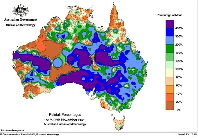
From the 1st to the 25th November 2021, regionally around 500% of average precipitation fall in parts of the continent /map below/.
In Canberra, during this period, 148 mm fell, which is the largest November monthly rainfall in history!
The most hit by severe storms were South Australia, New South Wales, southern Queensland, southern Northern Territory, and central parts of Western Australia.
Moreover, anomalously wet Summer 2021/2022 is mainly along East Coast, in the Southeast, and in the Perth region, in the southwest, too.
Extremely stormy conditions hit even Southern Island, New Zealand, too, with significant rainfall events. This frontal boundary was linked with storms above Australia.
Into very stormy pattern above Australia are contributing except for La Nina MJO and IOD patterns – MJO in its wet phase above SE Asia and IOD in its negative phase.
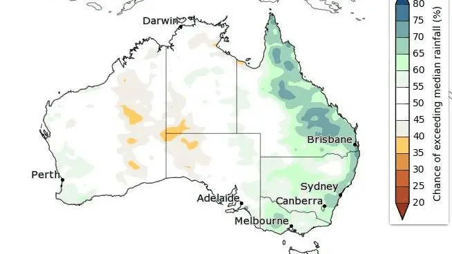
Colder and very stormy weather should according to seasonal forecasts persists above Australia approximately until the half of Summer 2021/2022, while the second half, with positive IOD and a shift of Cyclone season 2021/2022 above Africa, western India, and the southern Middle East, should be hotter and drier – with a possible peak of summer, drought, heatwaves, and wildfires.
Summer 2021/2022 forecast for Australia and Oceania you should visit here: https://mkweather.com/summer-2021-2022-forecast-for-australia-and-oceania-stormy-colder-la-nina-pattern-above-the-continent/.