Winter 2021/2022 is coming and we are bringing continental updates of predicted patterns for Europe, North America, Asia, Africa (Winter + Summer 2021/2022), Australia (Summer 2021/2022), and South America (Summer 2021/2022).
In the last articles, we looked at forecasted Winter 2021/2022 conditions in Europe /https://mkweather.com/winter-2021-2022-forecast-for-europe-early-extreme-arctic-and-siberian-blasts-and-blizzards-late-dry-and-very-warm-conditions// and North America /https://mkweather.com/winter-2021-2022-forecast-for-north-america-a-peak-of-winter-with-extreme-arctic-blasts-and-blizzards-in-february-2022//and Asia /https://mkweather.com/winter-2021-2022-forecast-for-asia-early-extreme-arctic-and-siberian-blasts-and-blizzards-late-dry-and-warm-conditions//. Now we should look at the upcoming summer in Australia and Oceania.
The last update of the Winter forecast for the Northern Hemisphere we published here / https://mkweather.com/winter-2021-2022-forecast-extreme-frosts-in-eurasia-in-december-in-north-america-in-february-early-canadian-stratospheric-warming-ne-pacific-blob-la-nina-qbo-and-shift-from-nao-to-nao-such-le/ /.
6 main circulation patterns and important parameters will be affecting conditions in Australia and Oceania during an upcoming summer:
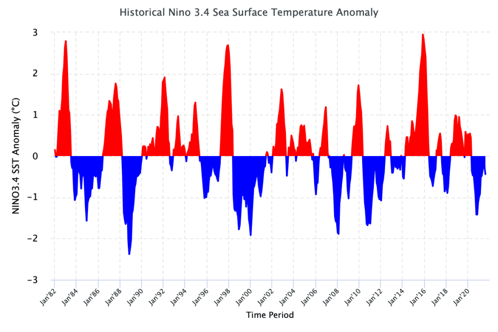
- Still low solar activity: We are still after a solar minimum, at the beginning of a 25. solar cycle, with a weaker predicted solar cycle. Weaker solar cycles were in the last centuries associated mainly with El-nino phases, but El-nino, maybe with a Godzilla character, is currently forecasted only for Autumn 2022 and years 2023, 2024 and maybe 2025 /https://mkweather.com/2022-2023-forecast-chances-for-el-nino//. Little Ice Age = low solar activity = El nino and high solar activity (stronger sun cycles) = La nina in long-term perspective.
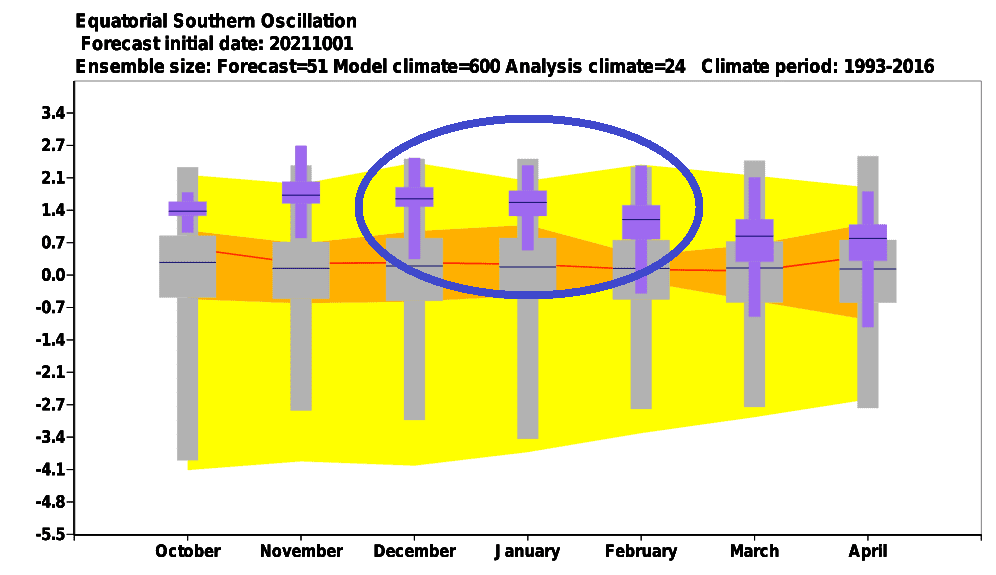
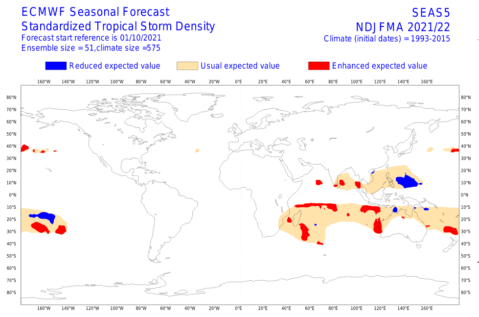
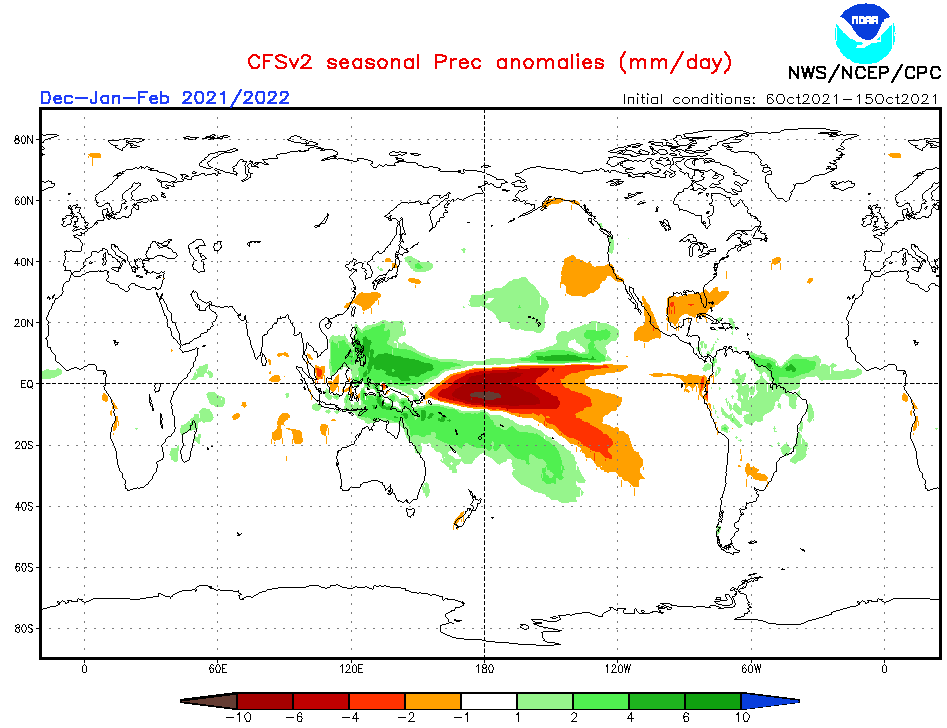
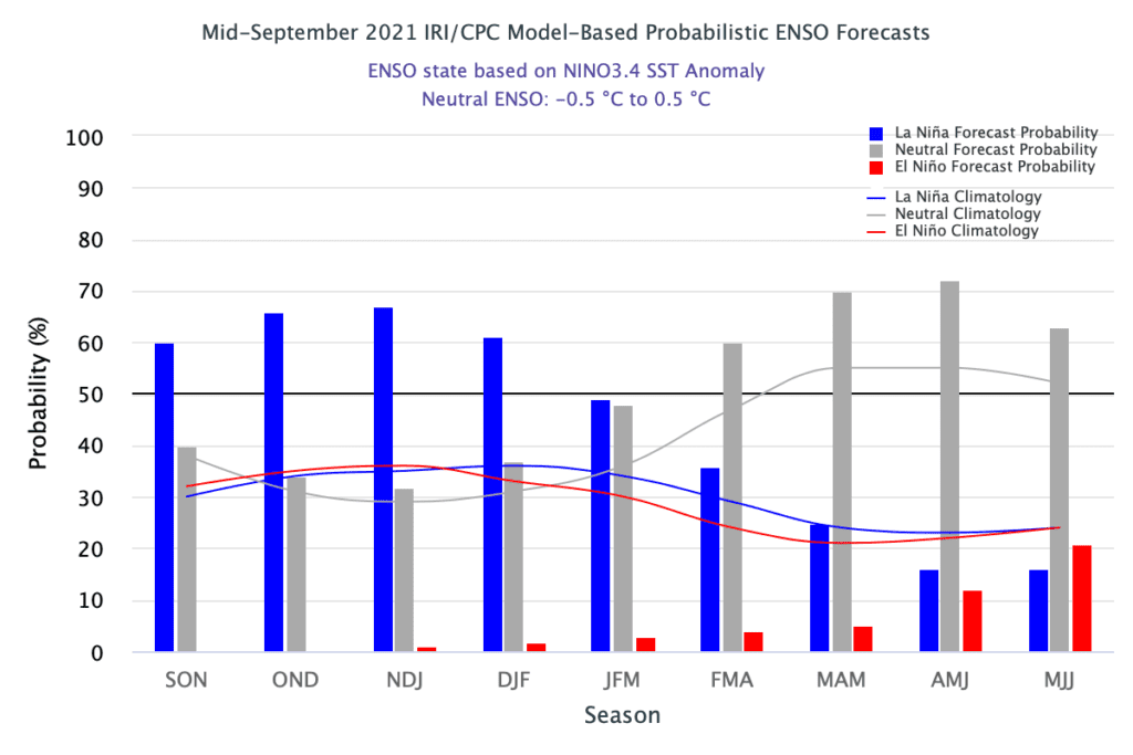
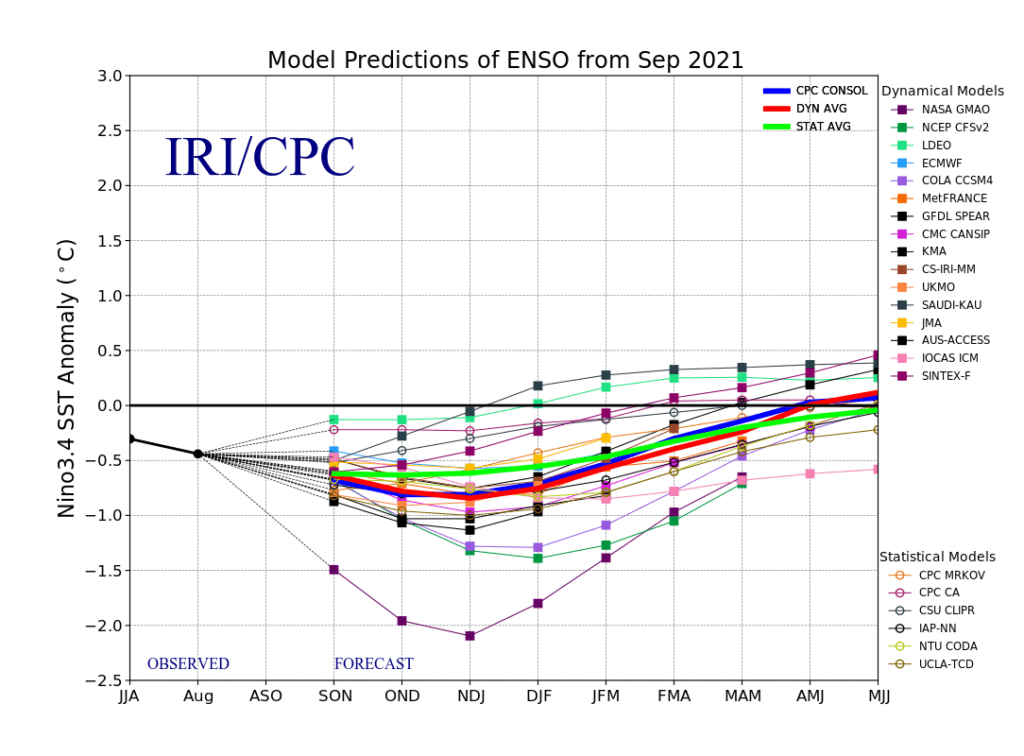
- Re-strengthening La Nina pattern: La nina in Australia is linked with mostly very stormy and colder pattern, with combinations with MJO and IOD, while El nino is Australia very hot and dry, /https://mkweather.com/2022-2023-forecast-chances-for-el-nino//. Thanks to an upcoming La nina, wildfire season in Australia will be weaker than usual, heatwaves will be milder, but problems with a Spider season or a Mice plague should appear, again. Similarly, flood risk is during La nina much higher across parts of Astralia. Weaker La nina signature will be possible maybe in Adelaide region, where heatwaves and temperature above average is possible. In Oceania, La nina is bringing a traditional mix of weather regimes, from stormy and hot trought hot and dry and cold and dry. It is needed to expect a powerful Australian and Oceanian Cyclone season 2021/2022, with a big contribution from La nina circulation.
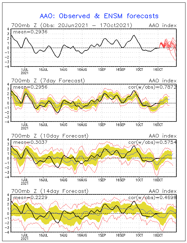
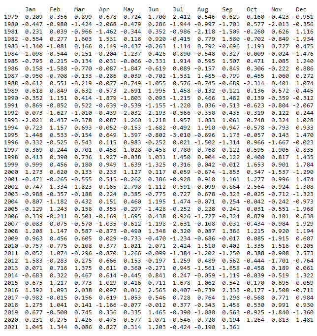
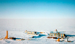
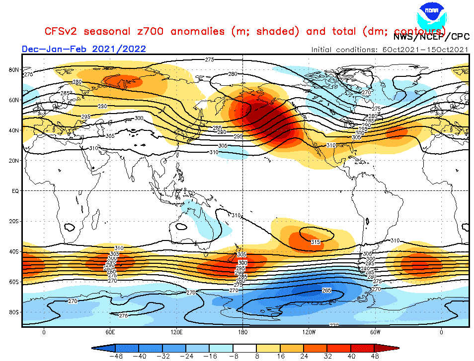
- AAO / SAM – Will bring Antarctic Oscillation positive phases an trend remains preserved? South Pole experienced with the coldest winter since records has begun /https://mkweather.com/the-south-pole-with-the-coldest-winter-in-history-average-temperature-april-september-half-year-only-610c// with anomalous temperatures even around 30. September 2021 /https://mkweather.com/vostok-794c-only-06c-from-the-all-time-october-record// thanks to positive phases of AAO / SAM (Antarctic Oscillation / Southern Annular Mode). After 2000, positive phases are more often troughout all year, including summer months (December, January, February), therefore Antarctic fronts should stay far from Australia during summer months, in the case of AAO+ / SAM+. Anomaly should be linked with drier southern New Zealand or heatwaves in South Australia, however, La nina pattern in the region is leading.
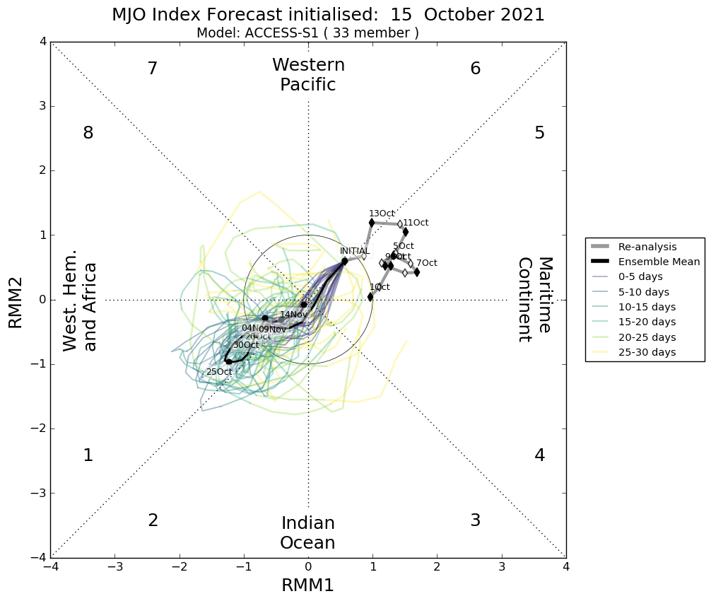
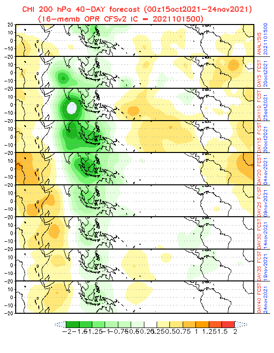
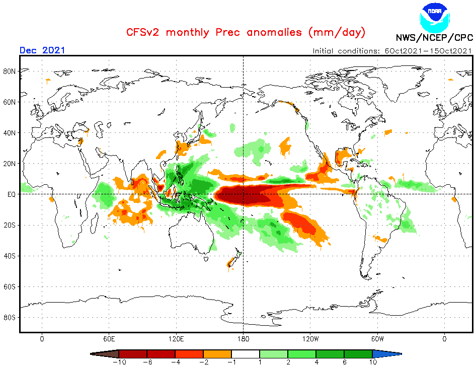
- Wet MJO above Southeastern Asia: Wet MJO together with La nina and negative IOD should contribute to a powerful cyclone season in Australia and stormy times in Australia. Its predicted, that pattern should be stronger in the first half of Summer 2021/2022 and the second half of the summer should be calmer.
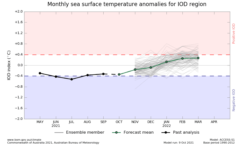
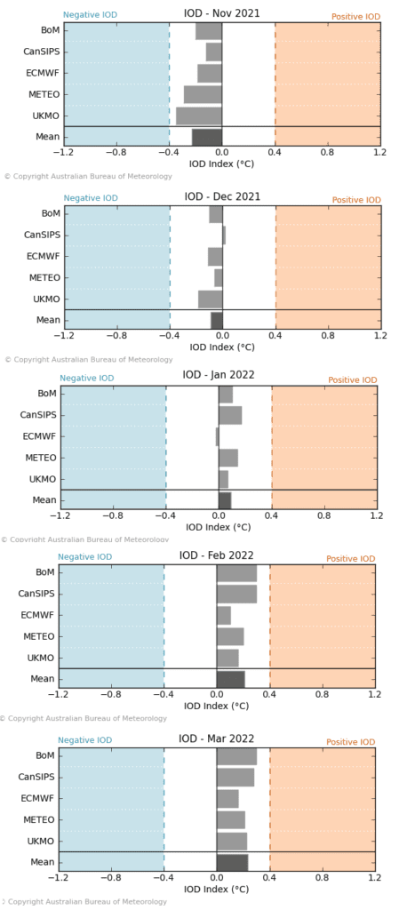
- IOD (Indian Ocean Dipole) shift from negative to positive phase: IOD is forecasted to shift from its negative to its positive phase during Winter 2021/2022, what means, that early winter should bring in eastern Indian Ocean region (including all Australia) very stormy conditions, together with wet MJO and La nina, while western Indian Ocean will be anomalously hot and dry. Positive IOD in late witner should be linked with calmer conditions, and weakening activity of tropical cyclones mainly in parts of Western Australia and Northern Territory and a shift of tropical activity into western Indian Ocean.
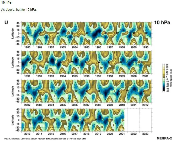
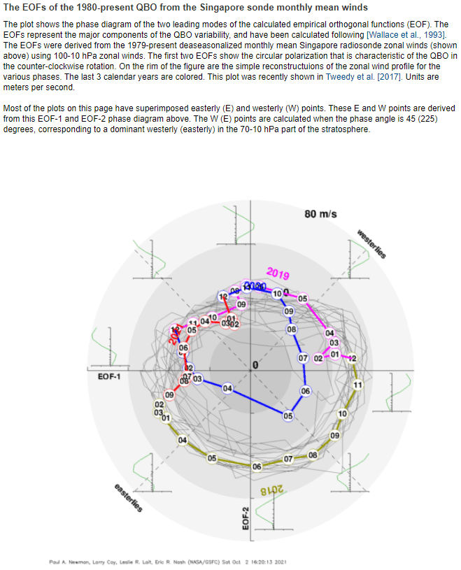
- QBO in Easterly phase: Although QBO is forecasted to stay in a colder phase during the season, with an usual manifestations in tropical and mid-latitudes in Southern Hemisphere.
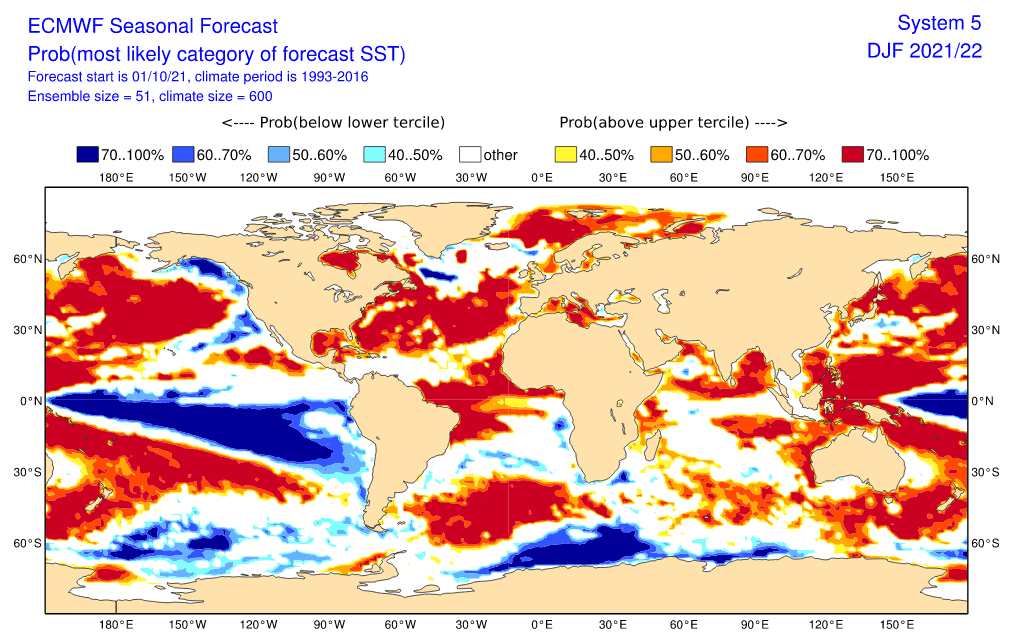
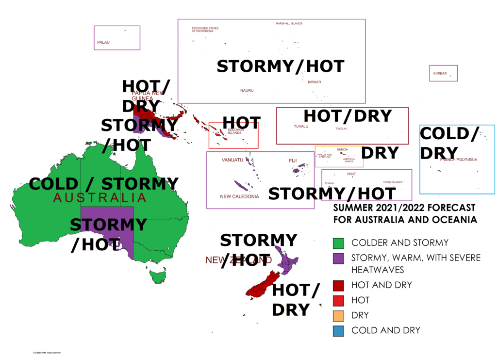
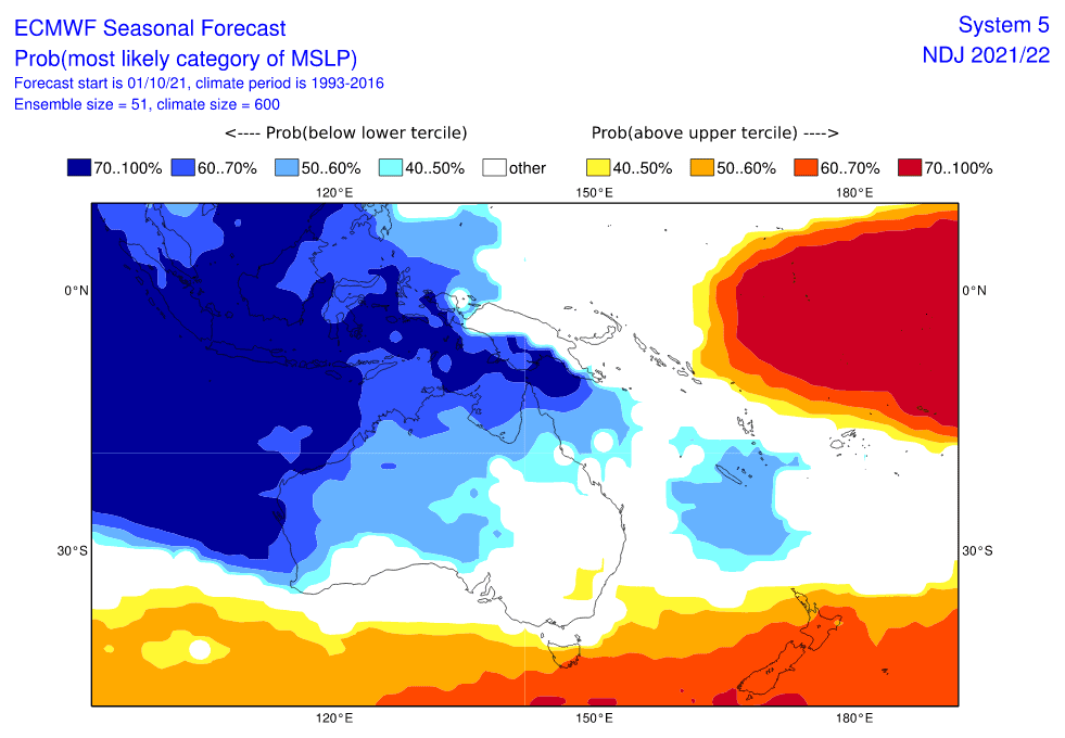
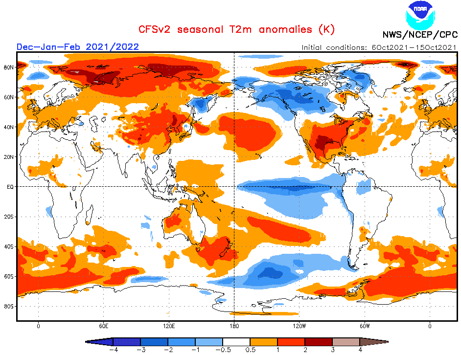
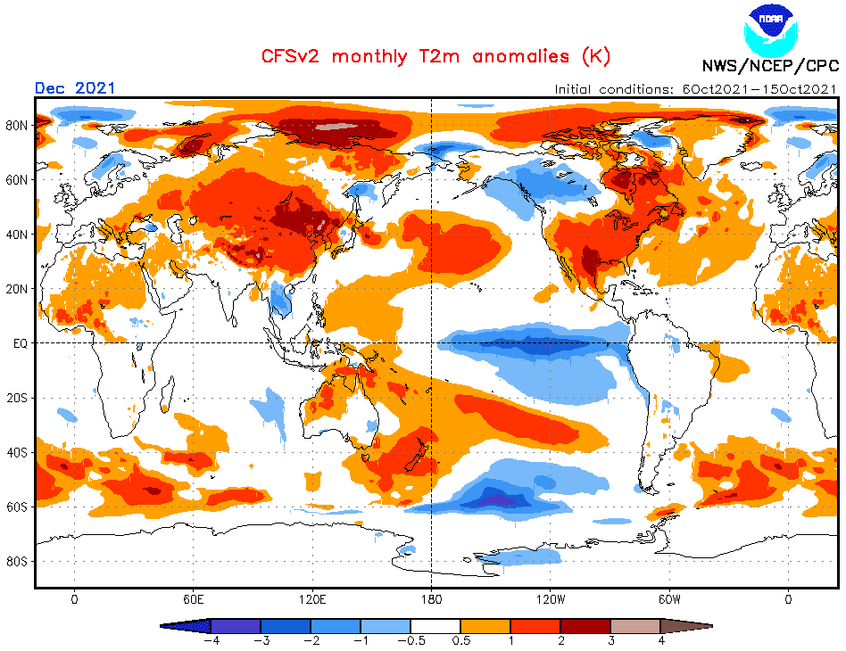
Now, we should look at a forecasted map for Summer 2021/2022 for Australia and 6 main sectors, with similar regimes of weather:
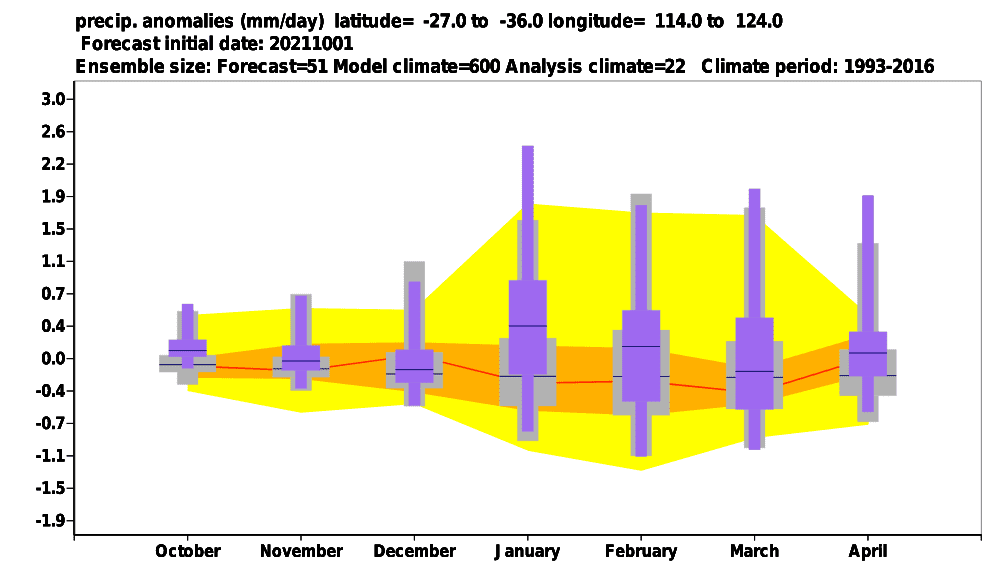
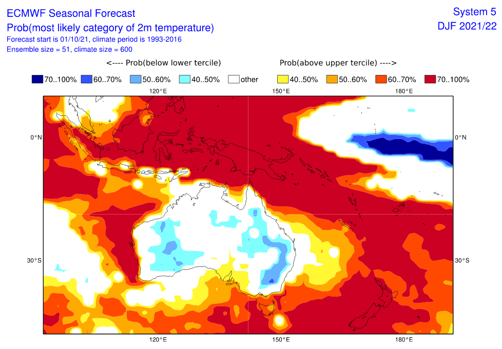
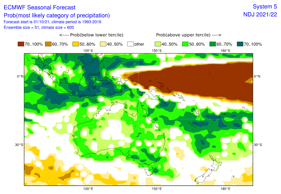
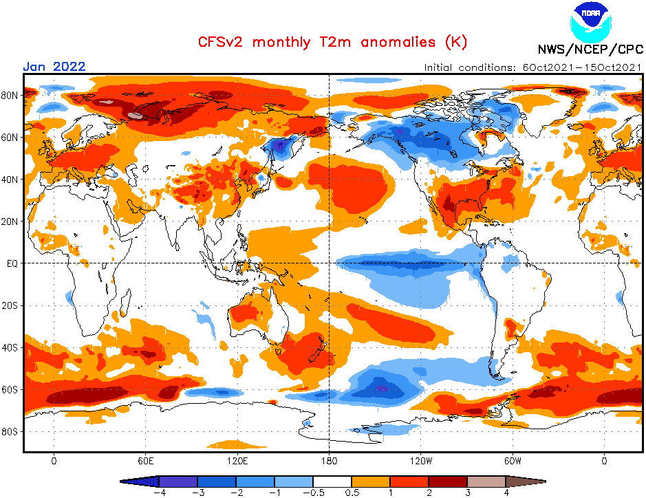
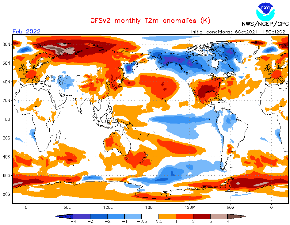
A) AUSTRALIA EXCLUDING SOUTH-AUSTRALIAN COAST: A typical La Nina pattern with a contribution of wet MJO and negative IOD in the first half of Summer 2021/2022 means a stormy and colder pattern almost for all of Australia. Above-average cyclone season, storms with hail, winds, heavy rain and damaging lighting will be very spread, mainly during the first half of summer. Summer should be peaking in its second half thanks to positive IOD and possibly weaker MJO in many regions. Wildfire season is expected to be weaker, but Spider season and Mice plague should appear again thanks to moisture. Heatwaves won´t be so extreme and so long such as usual and drought won´t be so severe such as in El Nino years.
B) SOUTH-AUSTRALIAN COAST, NORTHERN NEW ZEALAND, NEW CALEDONIA, FIJI, VANUATU, KIRIBATI, SOUTHERN PAPUA-NEW GUINEA: Isolated warm anomaly about Adelaide region should mean more heatwaves for the area, more drought, and regional wildfires, but still with a relatively high storm activity and a possibility of severe storms. Southern Papua New Guinea should be affected by a Cyclone season and cyclones in Northern New Zealand, Fiji, New Caledonia, and Vanuatu will be stronger, such as usual, too, still with very warm conditions. It´s a typical La Nina pattern for the region.
C) SOUTHERN NEW ZEALAND, NORTHERN PAPUA-NEW GUINEA: A possible AAO+ phase and far distance from cyclone season impact should generate hot and dry southern half of New Zealand. Northern Papua New Guinea should be thanks to La Nina hot and dry.
D) SOLOMON ISLANDS: regional hot anomaly (border region between dry northwest and stormy southeast).
E) SAMOA: Regional dry anomaly above Equatorial micro-states. La Nina-driven.
F) FRENCH POLYNESIA: Cold and dry anomaly, typical for La Nina. El Nino in the region is warm and stormy.
Although the next stormy and colder summer on the Australian continent is forecasted, any extreme wildfires aren’t expected. However, La Nina should bring a powerful Cyclone season 2021/2022 with widespread floods or severe storms, therefore don´t forget to watch current radar information and weather forecasts.
Additional materials for Winter 2021/2022 in Northern Hemisphere and Autumn/Spring 2021 forecasts:
The last updates of the Winter 2021/2022 forecast for Northern Hemisphere we published here – and it really appears, that the upcoming winter will be probably peaking in Europe, Asia, and North Africa around December 2021 and early January 2022 and in North America around February 2022 (forecasts are still confirming): https://mkweather.com/winter-2021-2022-forecast-extreme-frosts-in-eurasia-in-december-in-north-america-in-february-early-canadian-stratospheric-warming-ne-pacific-blob-la-nina-qbo-and-shift-from-nao-to-nao-such-le/; https://mkweather.com/winter-2021-2022-forecast-a-peak-near-nao-already-in-december-ne-pacific-warm-blob-nao-and-early-spring-in-february-north-america-oppositely-warm-start-cold-end-of-winter/https://mkweather.com/mkweather-special-forecast-for-the-next-3-seasons-cold-autumn-2021-warmer-winter-2021-2022-cold-spring-2021-for-europe-a-peak-of-winter-in-its-colder-first-half-north-america-with-extreme-cold-2021-20/; https://mkweather.com/winter-2021-2022-forecast-the-first-reliable-estimates-extreme-cold-blasts-from-canada-and-western-siberia-snow-in-western-europe-and-eastern-asia-la-nina-qbo-to-qbo-shift-sufficient-nao-ao/ and we published ENSO outlook, too /https://mkweather.com/2022-2023-forecast-chances-for-el-nino//. It is also worth mentioning the Russian forecast for Siberia for Winter 2021/2022 (agree with our forecasts) /https://mkweather.com/russian-meteorologists-expect-extreme-winter-around-december-january-2021-22//.
Continental forecasts for Autumn (in Southern Hemisphere Spring) 2021 we published here: https://mkweather.com/autumn-2021-forecast-for-europe-mostly-dry-and-frosty-autumn-be-prepared-for-early-severe-frosts/; https://mkweather.com/autumn-2021-forecast-for-north-america-long-indian-summer-and-weaker-hurricane-season-such-as-expected/; https://mkweather.com/autumn-2021-forecast-for-asia-strong-monsoon-for-s-se-e-asia-hot-and-dry-in-the-middle-east-late-siberian-cold-blasts-in-w-siberia-and-snow-calamities-in-e-siberia/; https://mkweather.com/spring-autumn-forecast-for-africa-mostly-hot-and-dry-parts-of-sahel-equatorial-africa-stormy-and-south-africa-stormy-and-cold/; https://mkweather.com/spring-2021-forecast-for-australia-and-oceania-under-la-nina-rules-cold-and-stormy-australia-warm-new-zealand-and-various-patterns-in-oceania/; https://mkweather.com/spring-2021-forecast-for-south-america-floods-and-drought-in-many-regions/.Mkweather until 30. November will be updating Winter 2021/2022 forecasts for Northern Hemisphere, yet, approximately 3-5 times.
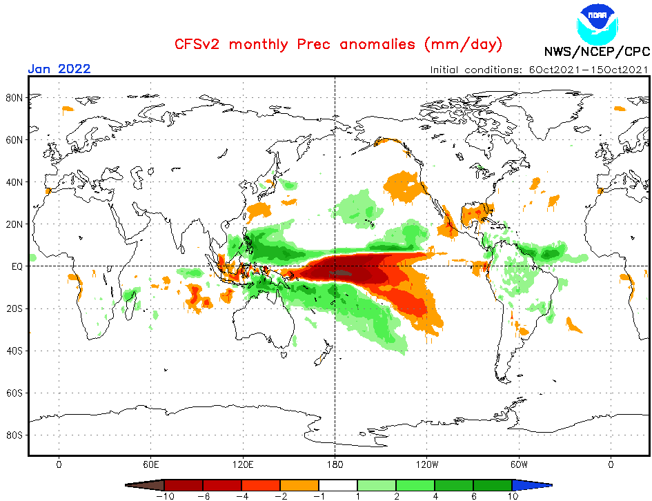
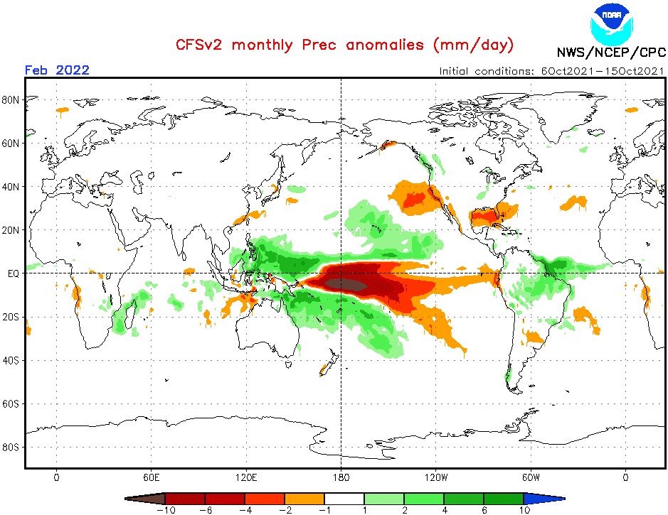
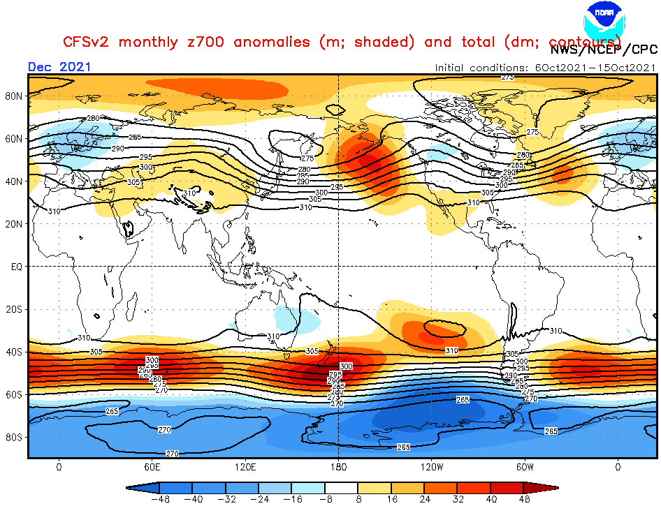
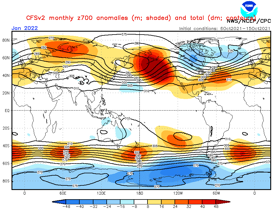
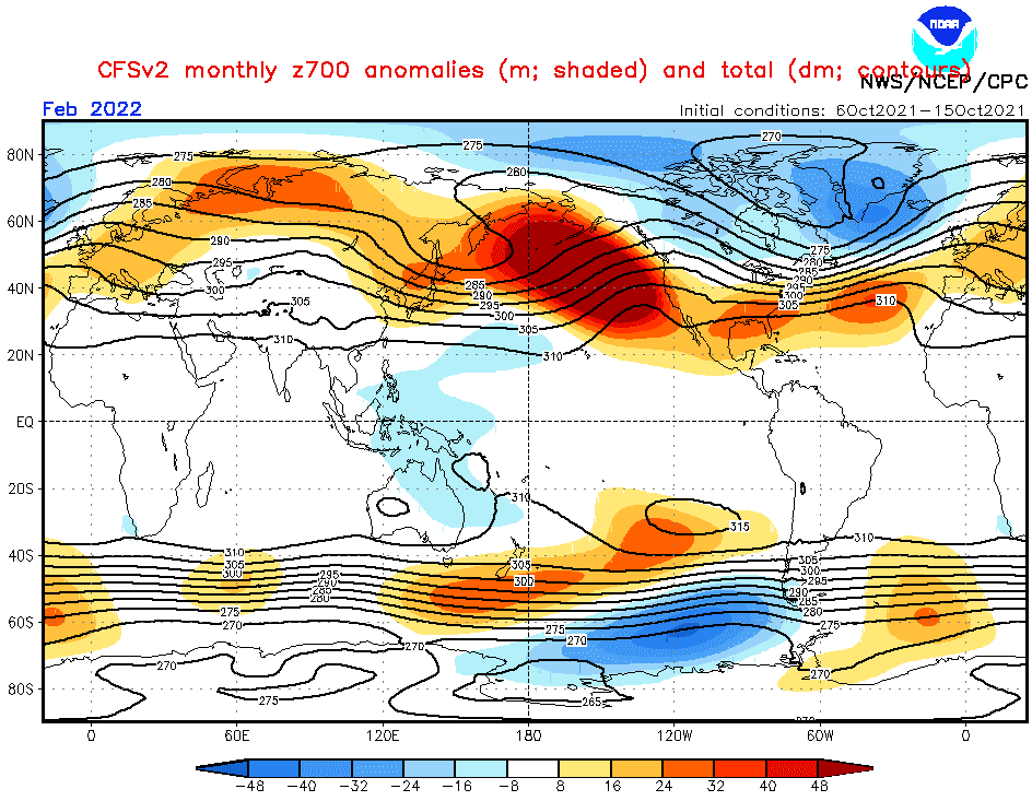
Source: https://www.cpc.ncep.noaa.gov/products/CFSv2/CFSv2_body.html
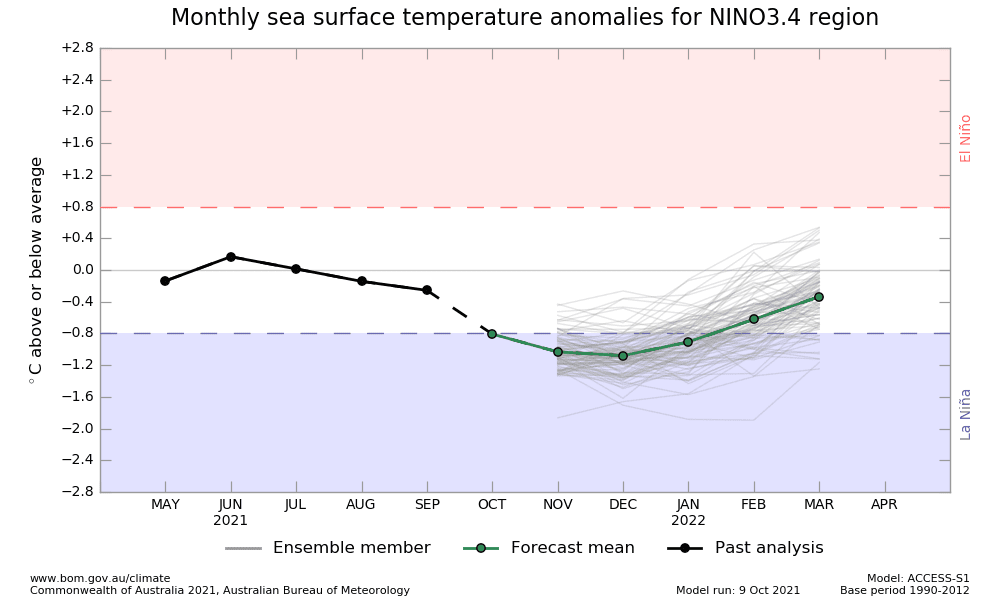
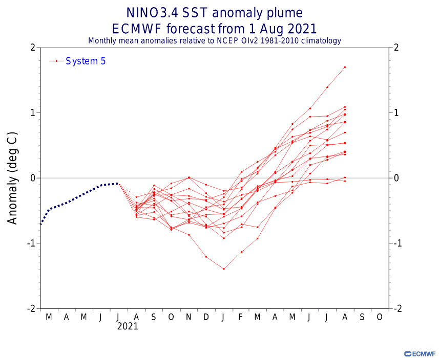
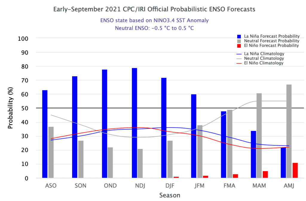
Source: https://iri.columbia.edu/our-expertise/climate/forecasts/enso/current/
Source: https://iri.columbia.edu/our-expertise/climate/forecasts/enso/current/
Source: https://iri.columbia.edu/our-expertise/climate/forecasts/enso/current/
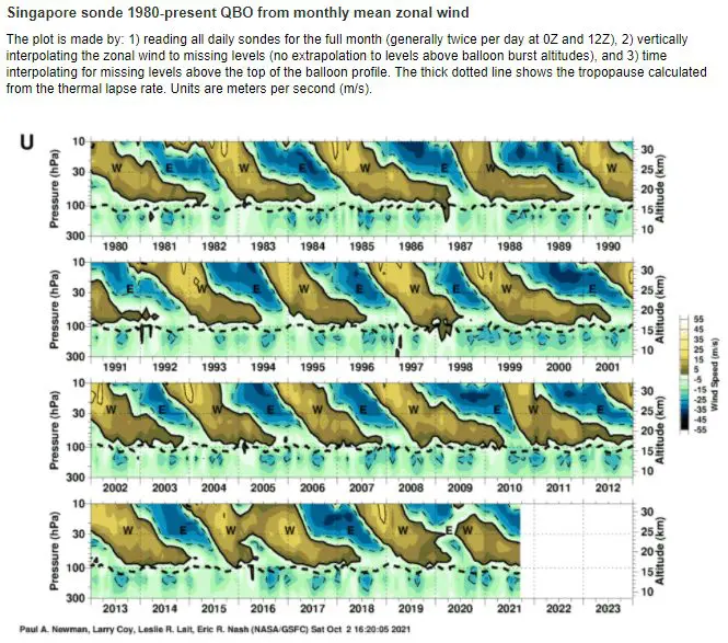
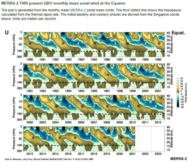
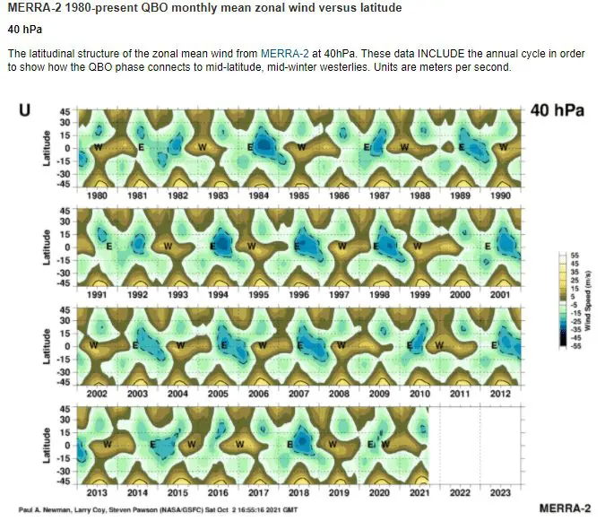
Source: https://acd-ext.gsfc.nasa.gov/Data_services/met/qbo/qbo.html
