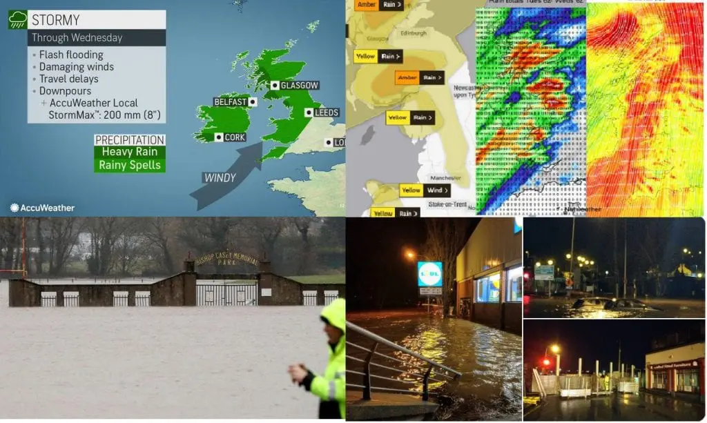
During last 48 hours (until Wednesday, 24. February 12Z), the following wind gusts were from the UK and Ireland reported: Cairngorm 193 km/h, 167 km/h Aonach Mor, 135 km/h Cairnwell Great Dun Fell 128 km/h Glen Ogle 124 km/h Capel Curig 122 km/h Lerwick 119 km/h, Casement Malin Head 104 km/h Roches Point 101 km/h.
Moreover, many parts, mainly in southern and western Ireland, Northern Ireland, Scotland, Wales and NW England report serious flood risk and already regional floods.
In southern Ireland and western Scotland, StormMax up to 200 mm is according to Accuweather possible until Thursday, then, colder air will start flowing above the islands and too above Europe from Friday, 26. February.
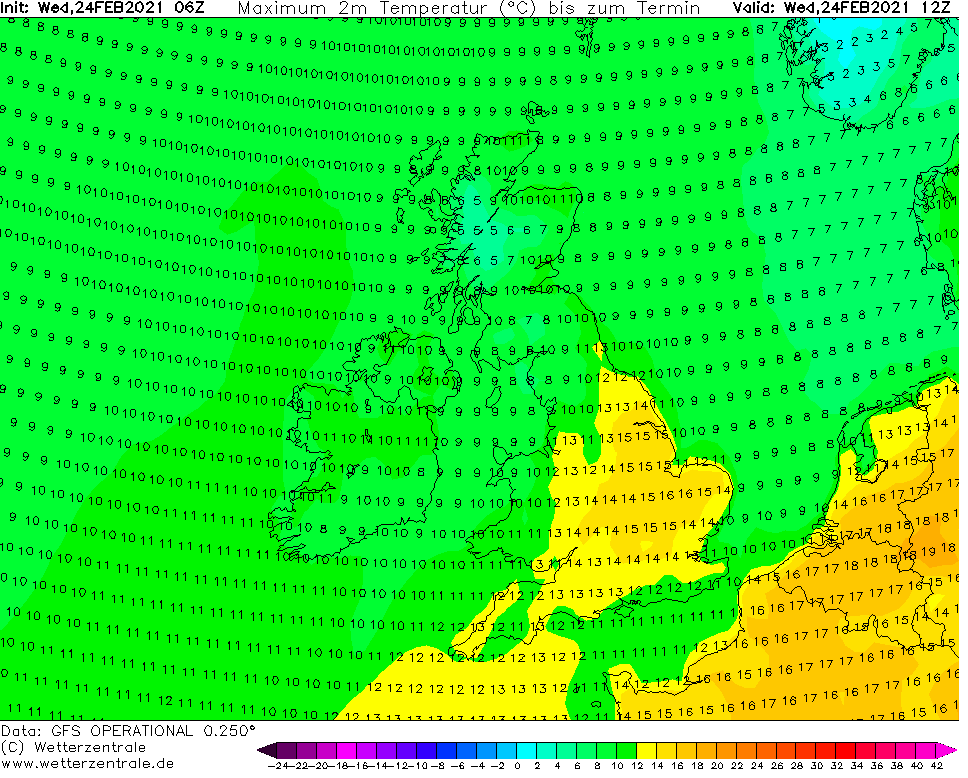
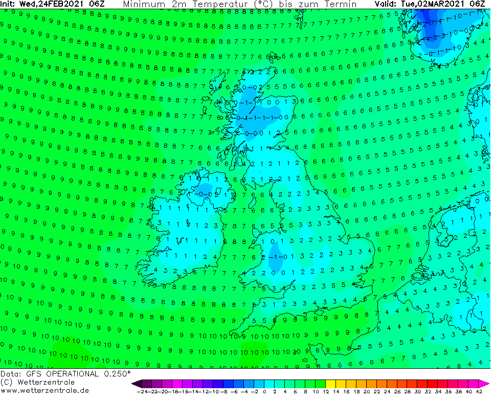
While on Wednesday, 24. February, maximum temperatures up to +18°C are still possible in eastern England, until Tuesday, 2. March, widespread ground frosts are expected across the islands.
Cooldown from Wednesday 24.2. (Tmax) to Tuesday 2.3. (Tmin) in British Islands /wetterzentrale.de
A storm tracking across the North Atlantic will pose the risk of dangerous flooding to Ireland and the United Kingdom this week as it stalls over both countries and unleashes heavy rain and strong winds: https://t.co/UgYyfJMGC9pic.twitter.com/bh3Hz16jke
— Breaking Weather by AccuWeather (@breakingweather) February 23, 2021
Latest rainfall totals with amounts over 30mm with selected stations over 60mm. There was also rain yesterday at many of the #Kerry & #Cork stations with total amounts of 80mm. This was an extreme rainfall event & this is now reflected in the high flows and extensive #flooding. pic.twitter.com/WpPEUP7ClU
— Flood Information Service Ireland (@floodingireland) February 23, 2021
In a small Welsh village in North Wales UK where we recently 'lost' our 250 year old bridge to storm floods and now have to go 'the long way round' 😐 pic.twitter.com/ThcMWSHZWv
Wild conditions with strong winds, high gusts and heavy rain. Easing for Northern Ireland this afternoon and still fine for SE Britain. Take care in the gusty winds and there are flood warnings. pic.twitter.com/1Hcb9USDFv
Met Eireann have issued a Status Yellow Wind Warning for Ireland until this evening, so extra vigilance is needed if you're behind the wheel today. Here are our tips on safe driving in high winds 👍https://t.co/O0FE9sQDaR
Very wet and windy across parts of Ireland, Northern Ireland and Scotland with very heavy and persistent rain along with wind gusts as high as 60mph ongoing. Flooding and some tree damage is possible. Stay safe!! pic.twitter.com/Ifv9vVAxtp
— Flood Information Service Ireland (@floodingireland) February 23, 2021
Quite an impactful 24-36 hours coming up for the NW of the UK esp Scotland & N Ireland (Cumbria, Pennines & N Wales too) with a plethora of warnings in place for both wind & rain inc an amber rain warning for 80-120mm rain locally. Risk of flooding & disruption. pic.twitter.com/2ZrDLsp9Ad
Heaviest rain today will be across parts of Scotland, N Ireland, NW England and at times NW Wales. Windy day everywhere. Black circles represent wind gusts @BBCBreakfast xxx pic.twitter.com/wVvlW6Oq5V