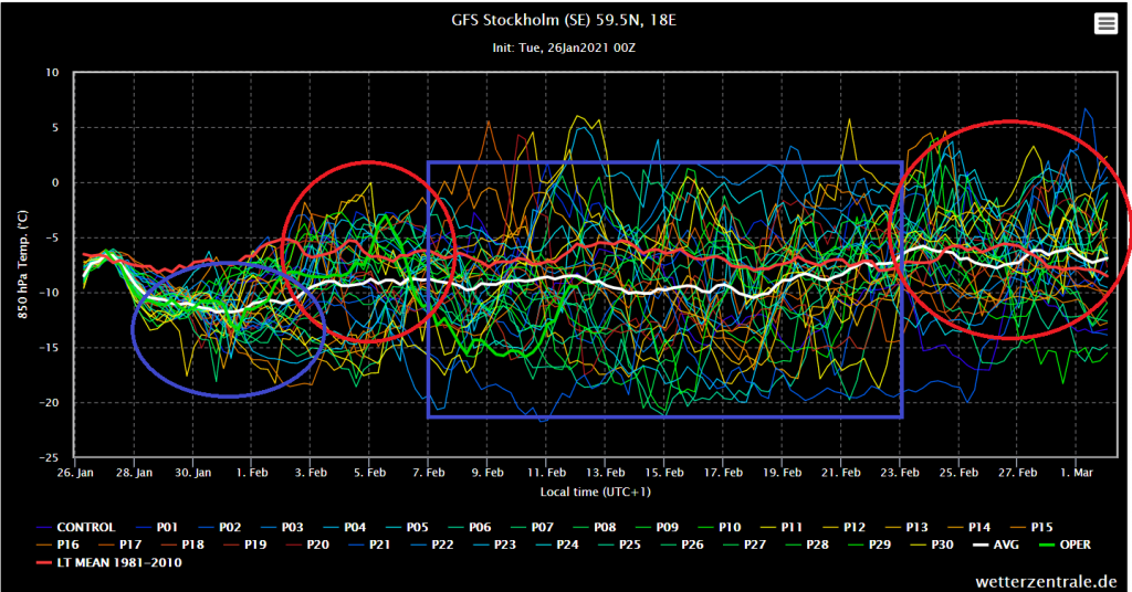
Least this conclusions we should read from ensemble forecasts for Stockholm
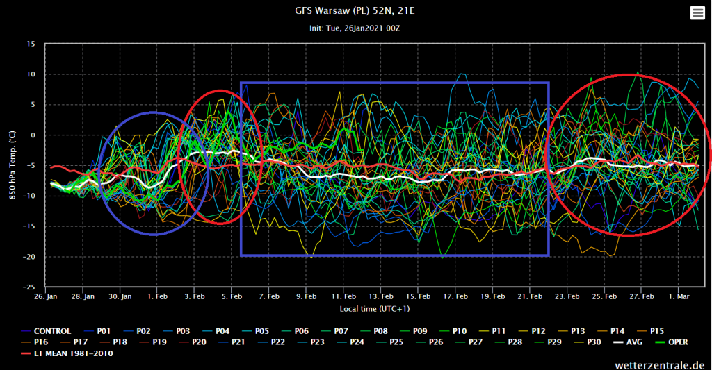
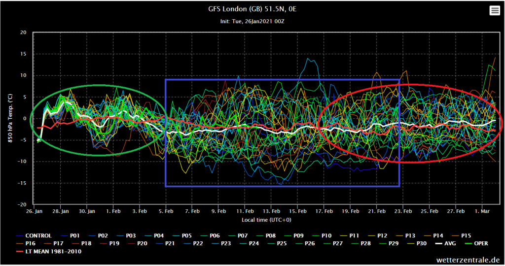
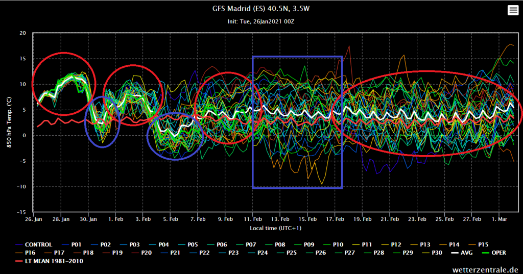
Similar conditions are forecasted for London and Warsaw , while southern parts of Europe won´t be so luckly
According to last runs of GFS, from 27.1.2021 12Z and 18Z, frosts only -17/-22°C should surprise Alpine and Carpathian basins and valleys between Sunday-Tuesday, 31.1. – 2.2.
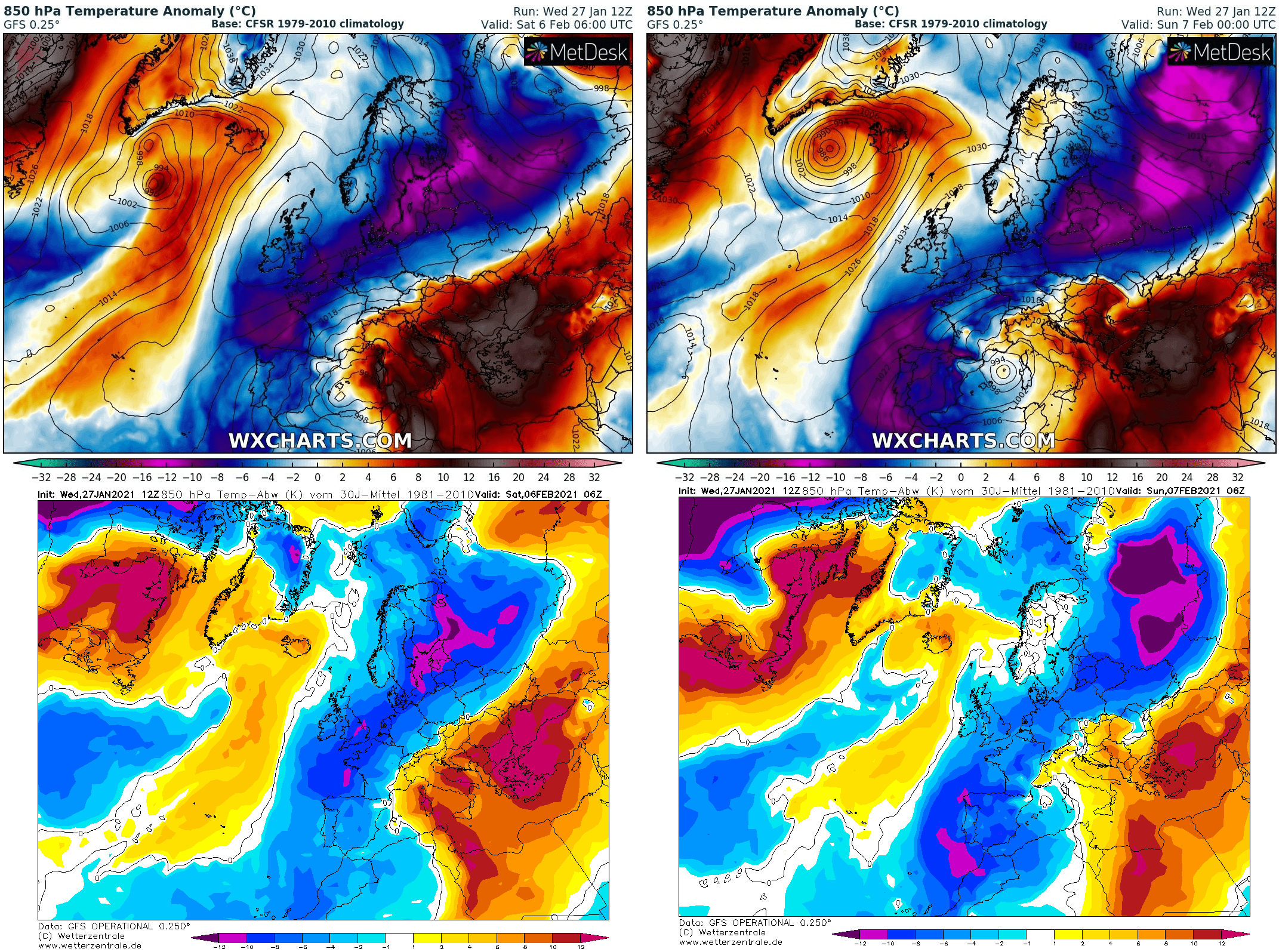
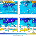
Already following weekend, 6.-7. Feburary should Siberian air shift over Scandinavia, Poland and Germany up to British Island, Benelux, France and Spain, with promised strong frosts
However, Wednesday´s outputs of main run are again little warmer than previous, with -20/-25°CC probability in Alpine and Carpathian basins, maybe -20°C in northern Poland, and around -40°C in central Scandinavia
Approximately 1/3 of runs however for period between 5.-20. Feburary for Warsaw temperature in 850 hPa slightly below -15°C , what should mean 33% probability of even stronger frosts during the period .
After 20. February it looks like early spring preliminary Iberian Peninsula are expected summer days (above +25°C) already during the next period.
Forecasts will be furthermore updated and Mkweather brings every day fresh news.
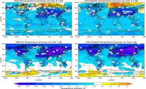
T850 hPa anomalies at the weekend 6.-7. February according to latest runs of GFS /wxcharts.com, wetterzentrale.de
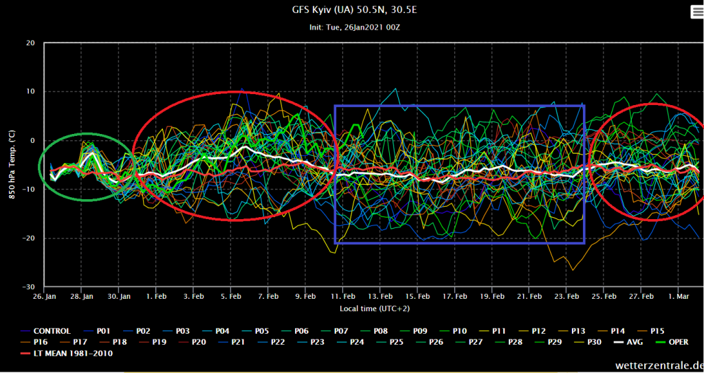
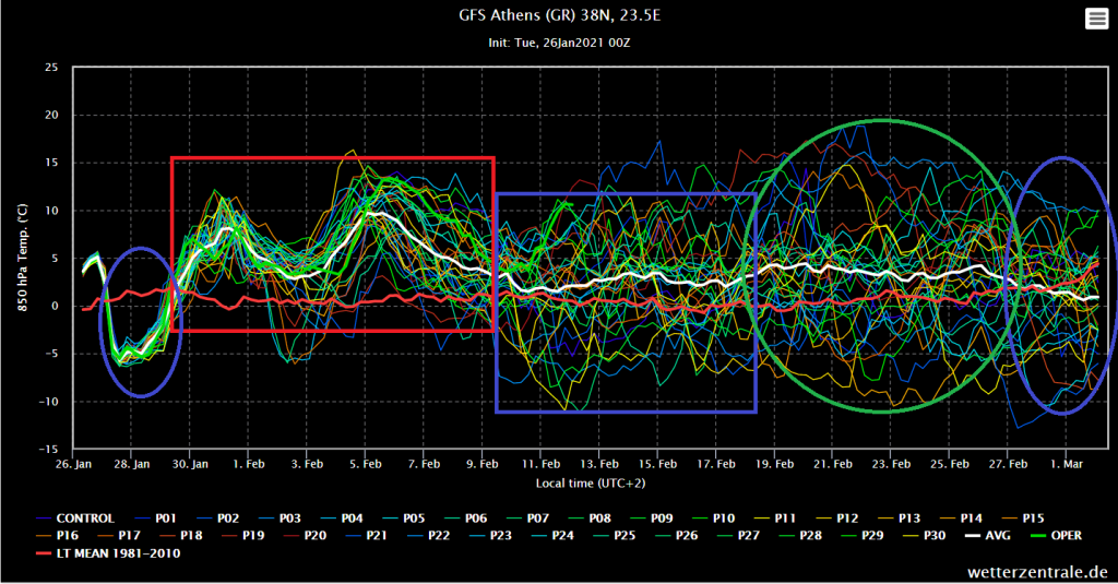
Ensemble forecasts for chosen cities in Europe /wetterzentrale.de
Read more:
https://mkweather.com/2021/01/27/the-uk-ireland-france-benelux-big-coldwave-between-4-12-february-london-and-paris-should-see-snow-again/
https://mkweather.com/2021/01/27/snow-in-syria-refugees-in-a-big-crisis/
https://mkweather.com/2021/01/27/dramatic-scenes-albanian-village-under-4-meters-of-snow/
https://mkweather.com/2021/01/27/peak-of-winter-in-northern-america-between-5-15-february-southern-usa-under-the-snow-including-grand-canyon/
https://mkweather.com/2021/01/26/british-islands-colder-than-eastern-europe-why-upcoming-february-coldwave-should-be-strange-2021/
https://mkweather.com/2021/01/26/20-25c-in-central-europe-forecasted-already-for-monday-tuesday-1-2-february-2021-mk/
https://mkweather.com/2021/01/26/snowstorm-ignacio-is-bringing-heavy-snowfall-parts-of-continental-europe-baltic-region-and-scandinavia-under-the-snow-2021/
https://mkweather.com/2021/01/26/the-most-extreme-forecast-of-the-year-should-be-winter-even-stronger-30c-in-central-europe-again/
https://mkweather.com/2021/01/25/170-km-h-storm-swept-through-mallorca-many-damages/
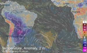
https://mkweather.com/2021/01/25/extreme-storms-and-floods-hit-belo-horizonte-sao-paulo-brazil/
https://mkweather.com/2021/01/25/australia-with-extreme-heatwave-and-wildfires-port-augusta-near-adelaide-453celsius/
https://mkweather.com/2021/01/25/the-2nd-and-3rd-peak-20-25c-in-central-europe-and-40-45c-in-scandinavia/
https://mkweather.com/2021/01/24/the-second-peak-is-here-the-heaviest-snowing-in-london-for-3-years-2021/
https://mkweather.com/2021/01/24/peak-of-winter-in-turkey-agri-345celsius/
https://mkweather.com/2021/01/24/frozen-animals-mongolia-480c-and-kazakhstan-404c-with-one-of-the-most-extreme-winters-on-record/
https://mkweather.com/2021/01/24/antarctica-set-to-coldest-january-since-1978-southern-hemisphere-hasnt-been-so-cold-almost-10-years/
https://mkweather.com/2021/01/24/tropical-activity-forecast-for-next-month-and-half-year-videos-ts-eloise-kimi-chalane-imogen-danilo/
https://mkweather.com/2021/01/24/peak-of-winter-in-turkey-agri-345celsius/
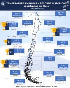
https://mkweather.com/2021/01/24/chile-with-widespread-wildfires-chillan-6-days-with-34-36c/
https://mkweather.com/2021/01/24/extreme-hailstorms-hit-argentina-patagonia-with-all-time-record-438c/
https://mkweather.com/2021/01/21/siberia-the-strongest-frosts-since-1996-up-to-584celsius/
https://mkweather.com/2021/01/21/big-agricultural-forecast-for-the-world-2021-weather-patterns-nao-signals-and-enso-signals-mk-2021/
https://mkweather.com/2021/01/21/southwest-usa-after-35c-94f-and-wildfires-a-powerful-coldwave-early-next-week-2021/
https://mkweather.com/2021/01/18/siberia-with-the-3rd-strongest-coldwave-since-2000-delyankir-581c-verkhoyansk-578c/
https://mkweather.com/2021/01/19/surprising-night-in-poland-biebrzy-297c/
https://mkweather.com/2021/01/19/romania-232c-and-bears-climbing-on-the-gate-serbia-189c-plitvice-waterfalls-in-croatia-frozen-winter-in-balkan-2021/
https://mkweather.com/2021/01/18/orlicke-zahori-czechia-on-the-polish-border-270celsius-2021/
https://mkweather.com/2021/01/18/slovakia-250celsius-the-strongest-frosts-since-legendary-2017/
https://mkweather.com/2021/01/18/in-bandon-near-balaton-in-hungary-was-measured-204celsius/
https://mkweather.com/2021/01/18/kozani-greece-193c-snow-in-istanbul-and-30c-forecast-for-turkey/
https://mkweather.com/2021/01/17/jelgava-latvia-310c-tied-daily-record-from-cruel-winter-1940/
https://mkweather.com/2021/01/17/belarus-287c-lithuania-275c-estonia-251celsius-next-night-will-be-deadly/
https://mkweather.com/2021/01/16/helsinki-61-cm-of-snow-n-e-finland-up-to-40celsius-extreme-snow-frosts/
https://mkweather.com/2021/01/16/france-under-the-snow-orange-warnings-and-216celsius-frosts-snow/
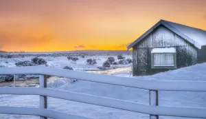
https://mkweather.com/2021/01/16/heart-attack-influenza-cancer-frostbites-hypothermia-covid-what-you-should-to-know-about-arctic-and-siberian-coldwaves/
https://mkweather.com/2021/01/16/samedan-switzerland-272celsius-siberian-air-is-back/
https://mkweather.com/2021/01/15/deadly-snowstorm-in-japan-13-dead-250-injuried-all-time-snow-records-in-many-stations-overcame/
https://mkweather.com/2021/01/15/extreme-winter-hit-southern-saudi-arabia-20celsius-and-snow-the-coldest-times-since-1971/
https://mkweather.com/2021/01/14/srinagar-kashmir-capital-with-the-lowest-temperature-since-1991-87c/
https://mkweather.com/2021/01/14/big-extreme-frosts-summary-temperature-records-from-europe-and-northern-hemisphere-during-the-first-half-of-the-peak-of-winter-2020-21/
https://mkweather.com/2021/01/14/sweden-with-the-worst-blizzard-for-10-years-scandinavia-again-with-40c-frosts/
https://mkweather.com/2021/01/13/vietnam-13celsius-and-snow-a-new-all-time-national-record-shanghai-china-and-srinagar-india-78c-the-lowest-temperature-since-2005-2012/
https://mkweather.com/2021/01/11/lienz-austria-235c-the-lowest-temperature-since-1987-switzerland-with-corrected-280celsius/
https://mkweather.com/2021/01/11/dolina-di-campoluzzo-italy-siberian-396celsius/
https://mkweather.com/2021/01/11/switzerland-264celsius-czechia-26c-austria-234c-in-valleys-around-1000-masl-but-the-worst-only-will-come/
https://mkweather.com/2021/01/11/switzerland-264celsius-czechia-26c-austria-234c-in-valleys-around-1000-masl-but-the-worst-only-will-come/
https://mkweather.com/2021/01/10/united-arab-emirates-with-all-time-temperature-record-abu-dhabi-20celsius/
https://mkweather.com/2021/01/09/madrid-50cm-of-snow-aemet-confirmed-the-worst-snowfall-since-1971/
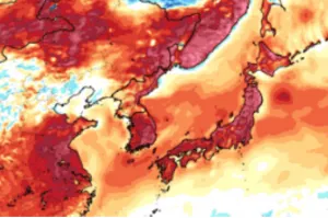
https://mkweather.com/2021/01/09/korea-and-japan-with-the-strongest-winter-since-1986-soeul-186c-north-korea-346c-japan-the-worst-snowstorm-for-35-years/
https://mkweather.com/2021/01/07/china-reports-50-year-frosts-beijing-city-196c-the-lowest-temperature-since-1966/
https://mkweather.com/2021/01/07/siberian-winter-in-the-spain-341c-new-national-temperature-record/
https://mkweather.com/2021/01/02/extreme-winter-already-in-japan-326c/
https://mkweather.com/2021/01/01/the-most-broken-circulation-on-earth-in-history-aleutian-low-921-hpa-equal-to-a-category-5-hurricane-deepest-within-all-time-records/
https://mkweather.com/2021/01/01/10943-hpa-mongolia-with-the-highest-measured-air-pressure-on-earth-in-history/
https://mkweather.com/2020/12/29/siberian-blocking-extreme-cold-air-in-norway-433c-finland-411c-only-week-after-all-time-december-scandinavian-record-18c/
https://mkweather.com/2020/12/28/oymyakon-lowest-temperature-since-2002-572c-in-monstrous-pressure-high-1076-hpa/