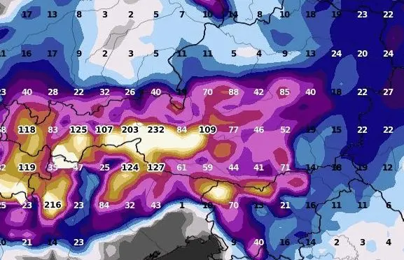
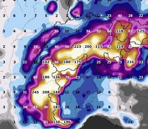
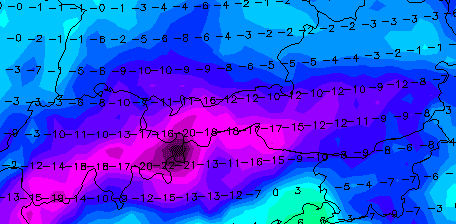
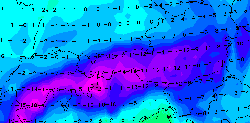
-20°C in Austria before the arrival of the blizzard (20-30 cm for Vienna!), after the blizzard, will be even colder! Blizzard for Switzerland, and parts of southern Germany, eastern France, northern Italy, or Slovenia, too!

Extreme blizzard is already until the end of the current workweek forecasted for Austria, Switzerland, and parts of southern Germany, eastern France, northern Italy, or Slovenia.
While in Bratislava should be a little more snow such as in Vienna /https://mkweather.com/bratislava-should-surprise-40-cm-of-snowfall-the-metropolitan-city-is-preparing-for-snow-calamity//, Austrian capital city, or its closer metropolitan region, should surprise 20 – 30, in the warmest parts of the city 10 – 20 cm of fresh snow.
Much worse will be a situation in the Alps, where up to 1 meter of snow is possible just in lower situated basins and valleys below 1000 MASL – including densely populated parts of the country.
A similar situation is forecasted for other mentioned countries and regions.
Before a severe blizzard, extremely cold air thanks to snow cover, dry and weak winds before the arrival of frontal boundary appeared on 8. December 2021.
Minimum temperatures in lower situated areas below 1000 MASL dropped up to -20°C: Zeltweg, 678 MASL, reported only -19,6°C, Weitensfeld, 705 MASL only -18,7°C, Saint Michael Im Lungau 1094 MASL, -18,3°C and Radstadt, 836 MASL only -18,1°C.
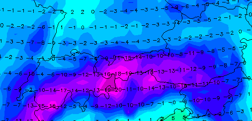
After the blizzard (Friday – Sunday, 10.-12. December 2021), minimum temperatures in Alpine regions should fall even lower, up to the interval -20/-25°C below 1000 MASL!
In higher elevated Alpine basins and valleys /e.g. https://doline.meteotriveneto.it/minima-assoluta// elevated 1500 – 2500 MASL, frosts -30/-40°C are possible.
All during extreme temperature records across all Northern Hemisphere:
Only before a few hours have appeared the strongest early frosts in the Siberian coldest region in all-time history (-61,0°C) /https://mkweather.com/historical-times-for-siberia-610c-has-never-been-measured-so-early//.
In Canadian Arctic, frosts up to -46,0°C have appeared, so far – in many regions, it´s the strongest earliest frosts since 2004 /https://mkweather.com/eureka-431c-the-lowest-temperatures-in-canadian-arctic-in-early-winter-since-2004/; https://mkweather.com/canada-460c-daily-records-in-yukon-were-broken//.
In Europe, the strongest early frosts since 1945 have surprised Sweden (-43,8°C) /https://mkweather.com/the-strongest-early-frosts-in-the-baltic-region-in-62-years-since-1959-tartu-estonia-276c-zoseni-latvia-264c//, the strongest early frosts since 1959 Estonia (-27,6°C) /https://mkweather.com/the-strongest-early-frosts-in-the-baltic-region-in-62-years-since-1959-tartu-estonia-276c-zoseni-latvia-264c// and in valleys in continental Europe was measured -22,0°C so far /https://mkweather.com/220c-in-pontets-france//.
All after anomalously cold Arctic, with the 2nd highest Arctic Sea Ice Extent in the last 15 years /https://mkweather.com/arctic-sea-ice-extent-is-the-2nd-highest-in-15-years/; https://mkweather.com/20-vessels-stuck-and-ice-locked-in-northern-sea-route-the-arctic//.
Therefore, stay safe and warm and will be prepared for the next manifestations of severe winter.
