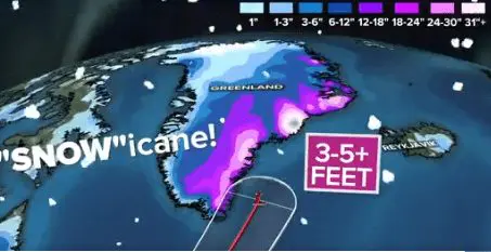
Snowicane in Greenland! Ex-hurricane Larry brings 1,5 meters / 5 feet of snow in southeastern Greenland!
The first forecasts from early September 2021 were telling, that ex-hurricane Larry hits British Islands, where should bring severe storms, winds, or floods.
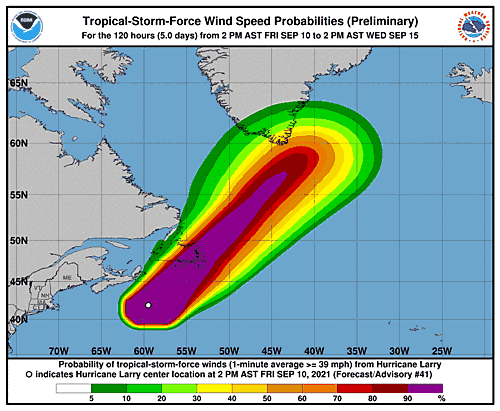
Forecasts during the current week shifted the projected stormtrack of remnants of a major Hurricane Larry above southeastern Greenland and Iceland, with significant impact in the region and the first winter-season blizzard.
Firstly, Larry hit Newfoundland, Canada, such a Category 1 hurricane, with maximum wind gusts up to an unbelievable 182 km/h in Cape St Mary´s, currently is system downgrading into a tropical storm, then a tropical depression, and finally, remnants of the system hits southeastern Greenland in full power!
According to estimates, along the southeastern coast of Greenland, 3-5 inches / 100 – 150 cm of snow should fall during the next days from the event.
Thanks to the enormous amount of snowfall, which bring remnants of the system to Greenland, ex-hurricane Larry got an eloquent name: “a snowicane”!
After a transition of the system above the Arctic, severe coldwaves will appear in western Greenland, which should persist above the region next 2 weeks.
Meanwhile, Europe is preparing for a severe cold blast around 20. September, which later will shift above Central Asia, Middle East, and northeastern Africa /https://mkweather.com/siberian-blast-in-europe-around-20-september-temperatures-in-valleys-should-drop-up-to-5c//. In the same period, coldwave hits western Canada and western USA /https://mkweather.com/heatwave-in-the-western-half-of-the-usa-is-bringing-many-daily-temperature-records-extreme-coldwave-in-outlook-only-after-20-september-until-then-the-larges-wildfire-in-california-in-history-should//.
In North-American parts of the Arctic, very / extremely cold Winter 2021/2022 conditions are forecasted /https://mkweather.com/winter-2021-2022-forecast-the-first-reliable-estimates-extreme-cold-blasts-from-canada-and-western-siberia-snow-in-western-europe-and-eastern-asia-la-nina-qbo-to-qbo-shift-sufficient-nao-ao//