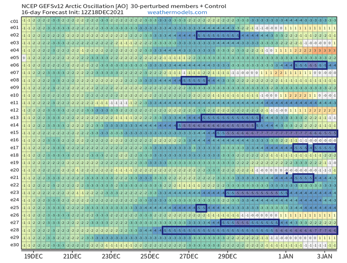
12/30 runs of GEFS expect an extremely low AO index from -5 to -7 for Christmas time and New Year!
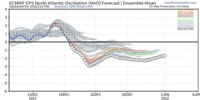
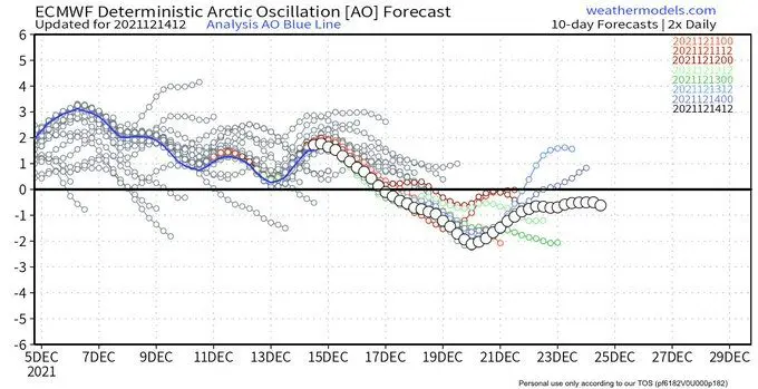
Upcoming coldwave in Europe will be, such as usually, associated with anomalously low AO and NAO indices.
Coldwaves (or heatwaves in summer) are coming approximately a week after the decline of AOi / NAOi and between 29. December 2021 – 6. January 2022, really, severe blizzard conditions are forecast /https://mkweather.com/the-long-term-snow-forecast-for-europe-until-30-january-2022//, with a subsequent peak of the winter (31. December 2021 – 9. January 2022) /https://mkweather.com/the-long-term-forecast-for-europe-until-30-january-2022//.
About expected blizzard conditions we wrote here /https://mkweather.com/gfs-expects-extreme-blizzards-in-europe-regionally-20-70-cm-locally-up-to-1-meter-of-snow-possible/; https://mkweather.com/white-christmas-2021-and-even-whiter-new-year-2022-for-europe//, and about expected extreme Siberian blasts here /https://mkweather.com/europe-before-an-aggressive-siberian-blast-european-russia-50c-scandinavia-45c-central-europe-france-eastern-europe-baltic-region-turkey-30c-balkan-and-italy-25c-b/; https://mkweather.com/40-45c-frosts-in-scandinavia-after-christmas/; https://mkweather.com/20c-in-england-and-benelux-around-sylvester-31-12-2021/; https://mkweather.com/chances-for-30c-around-sylvester-2021-31-12-in-central-europe-are-still-alive/; https://mkweather.com/italy-and-balkan-with-siberian-frosts-20-25c-on-new-year-turkey-30c-around-christmas//.
Forecast model GEFS returned for the period of 25. December 2021 – 4. January 2022 really low values of AO and NAO indices – 12 from 30 runs of the model expect AO index lower than -5 (from -5 to -7), whichare unseasonable values.
Only in early December 2021, AO index reached more than +3.0.
It will be declined about 8 points – these situations are often described such as a destabilization of polar vortex and winter SSWs (sudden stratospheric warming).
Near Arctic Oscillation like this, the extreme Arctic, Greenlandic and Siberian coldwaves are very probably across all Northern Hemisphere, mainly in Europe, Asia, North Africa, but too in parts of North America, despite East Coast (or eastern parts of the USA and Canada), where is NAO- associated with very warm anomalies.
Only 3 / 30 runs expect, that AOi won´t fall lower than -2.
A probability of AOi below -5 is therefore 4-times higher than it won´t fall below -2!
The strongest match for the extremely low AO index is for the last 3 December 2021 days, with subsequent severe frosts across the hemisphere, especially Europe, where cold weather should persist approximately until 10. January 2022.
Then, transition to a neutral NAO is possible, still with a possibility of strong regional frosts, or only neutral or not so much warmer weather until the end of the month.
Outlook for February and March is however NAO+ (Tweet below), therefore it´s possible, that Spring 2022 will come prematurely. All agree with our long-term Winter 2021/2022 forecasts before a few months /https://mkweather.com/winter-2021-2022-forecast-for-europe-early-extreme-arctic-and-siberian-blasts-and-blizzards-late-dry-and-very-warm-conditions/; https://mkweather.com/winter-2021-2022-forecast-for-northern-hemisphere//.
Quite a few players on the field with strongly negative Arctic Oscillation (-AO)
— Ryan Maue (@RyanMaue) December 18, 2021
(@weathermodels_) pic.twitter.com/NLUyZ7Onb6
This is really bad at Day 10 in volatile North Atlantic where predictability or skill of a given forecast can decrease quickly especially after a week.
— Ryan Maue (@RyanMaue) December 17, 2021
Let's look at the arithmetic mean of the North Atlantic Oscillation (NAO) calculated on each of 50-members.
Focus on Dec 20 pic.twitter.com/8zY3aBpLGn
THREAD (1/3)
— Weatherman Aditya (@AdityaKumar80) December 21, 2021
👉Series of WDs are expected over NW India as AO (Arctic Oscillation) turning negative.
👉(-)ve AO usually prefers more storms and precipitation in winter season over Middle east Asia.
👉These storms then travel towards Hills as a weak WD or an active one. pic.twitter.com/LTQD8FOJsS
An increasingly –#AO Arctic Oscillation & neutral to –#NAO going forward
— Marco Petagna (@Petagna) December 16, 2021
Born out in #weather charts
Our #omega block sees shift in the high N towards #Christmas, allowing a NE #airstream to become dominant at high latitudes, & #jetstream displaced S..sliding lows for UK?! pic.twitter.com/HRIp5ZOghr
ARCTIC OSCILLATION is forecast to enter a strongly negative phase in the second half of Dec – which increases the probability of much colder than normal temperatures at lower latitudes – including in Europe and Northeast Asia: https://t.co/nTAb5mE5uS pic.twitter.com/dQQflaK2xd
— John Kemp (@JKempEnergy) December 16, 2021
I am en route but the blog will publish at 3pm EST today. Exciting time for an #Arctic Oscillation blog: https://t.co/Gg8N2KHLUk pic.twitter.com/MDdhVKSf0q
— Judah Cohen (@judah47) December 15, 2021


