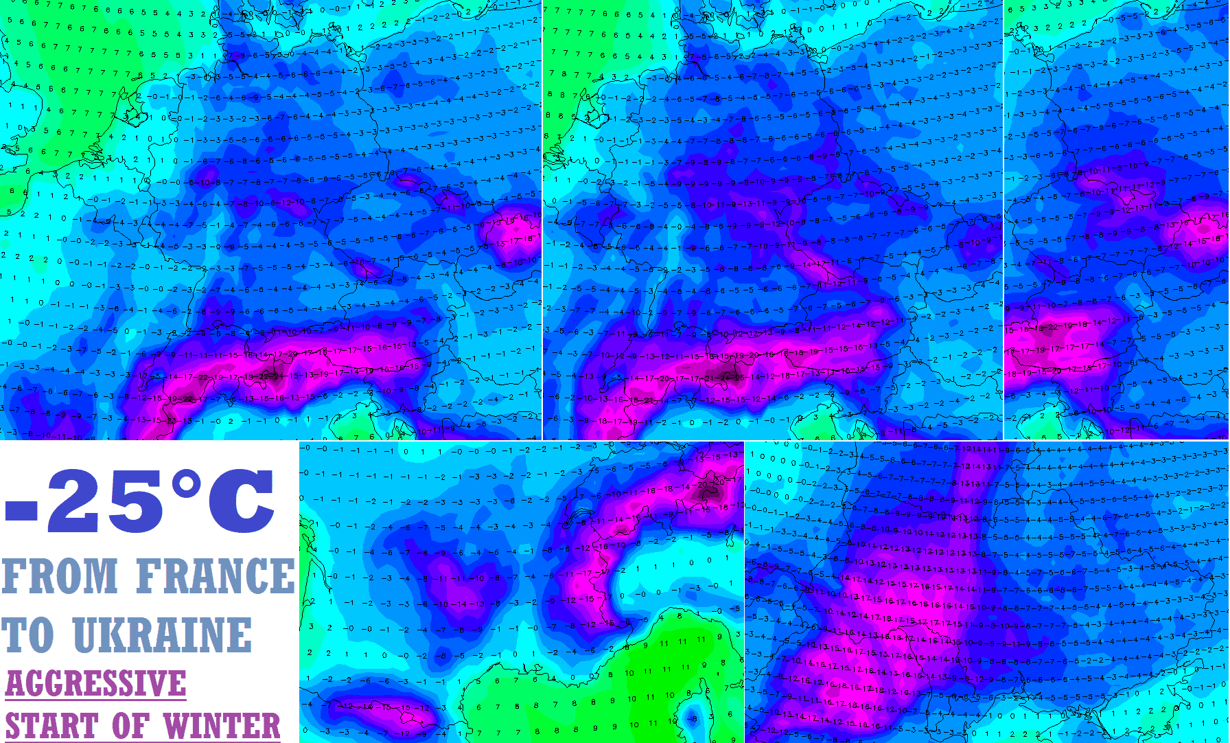
Arctic frosts up to -25°C hit the region from France to Ukraine (continental Europe)!
Europe hits premature and extremely strong winter!
A long period with very cold conditions is forecasted already between late November and early January 2021-2022 /visit our homepage, Winter forecast is available here: https://mkweather.com/winter-2021-2022-forecast-for-northern-hemisphere//.
NAO index is forecasted to fall to the lowest values since extreme frosts in Europe in January and February 2021, when frosts up to -35°C appeared in Europe (Czechia, Hungary around 1000 MASL) and April 2021, when up to -20,6°C was measured in low situated basins and valleys below 1000 MASL (Slovenia) /https://mkweather.com/nao-index-falls-to-2-0-the-lowest-value-since-legendary-35c-frosts-in-europe-in-january-february-2021-or-206c-in-april-2021//.
Temperature is forecasted to decrease probably until the New Year /https://mkweather.com/extremely-cold-weather-until-a-new-year-2022-arctic-air-should-come-in-3-peaks-around-30-11-14-12-and-christmas-wider-european-region-estimates// and the first cold period has already started on Tuesday, 23. November, with a peak in the last November days and early December 2021.
Not only severe frosts, possibly almost -40°C in Scandinavia, up to -25°C in continental Europe, -20°C in British Islands and -15°C in the Mediterranean, but too severe blizzards across the continent are forecasted!
Cold weather has a bad impact on the virological situation, heart attack rates, many kinds of cancer, or should cause hypothermia.
Blizzards should cause widespread problems on roads, highways, or railways and power outages, including metropolitan areas.
If you live in possible hit regions, we highly recommend you to watch current weather news, forecasts, warnings, and advisories.
From -20 to -25°C for many continental European countries (including Balkan)! Extreme winter hits from eastern France to western Ukraine and Romania!
Although severe frosts are prepared for continental Europe already in late November 2021, and regional -20°C and lower temperatures should appear, the coldest should be in the region around 5. December 2021, when frosts from -20°C to -25°C are possible in many continental European countries!
These temperatures will be very probably reached in eastern or central France, maybe in Belgium, probably in southern and central Germany, Switzerland, Austria, northern Italy, Czechia, Poland, Slovakia, northern Hungary, western Ukraine, Belarus, Romania, or maybe Slovenia, Croatia, Bosnia, and Herzegovina or Northern Macedonia in lower situated and densely populated basins and valleys below 1000MASL!
While France should be mainly in late November 2021, Central Europe in the first December days, or around 5. December 2021, into Ukraine and Romania, should the coldest air shift around 7.-10. December 2021.
Extreme frosts -15/-20°C are regionally possible in parts of lowlands with a colder climate, including metropolitan areas.
In many places, so-called “ice days with maximum temperatures below 0°C, rarely so-called “Arctic days” with maximum temperatures only below -10°C (fogs, peaking of coldwaves, the coldest valleys, snow…) are possible.
Moreover, blizzard conditions are very possible in many parts of the continent /https://mkweather.com/europe-under-the-snow-heavy-blizzards-on-the-way-in-these-regions-a-risk-of-snow-calamity//.
Frosts should be mainly in mountainous regions and near long outdoor activities health or even life-threatening, therefore stay safe, warm and watch current weather news, forecasts, warnings, and advisories.
Above continental Europe will shift really cold air masses, in T850 hPa with temperatures -10/-15°C.
The deepest frosts are forecasted in regions with heavy snowfall, weak winds, and very dry Arctic, Greenlandic or Siberian air masses.
It appears, that severe frosts should be continuing until New Year 2022 – Mkweather brings long-term outlooks updates for Europe already in the next articles.
During the next period, we will be bringing overviews of temperature records and updates of the next extremely cold outputs, furthermore.
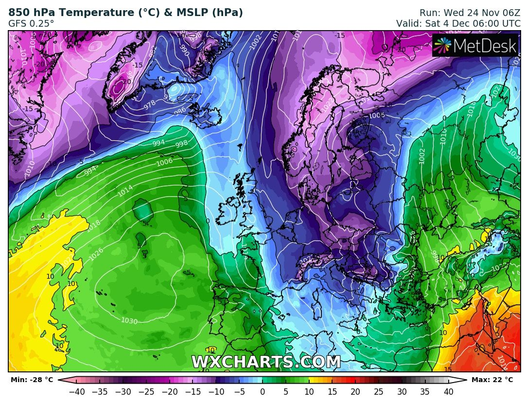


Source: wxcharts.com


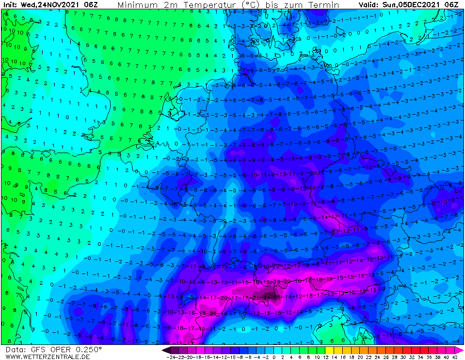


Source: wetterzentrale.de


