NAO index falls to -2.0, the lowest value since legendary -35°C frosts in Europe in January/February 2021 or -20,6°C in April 2021!
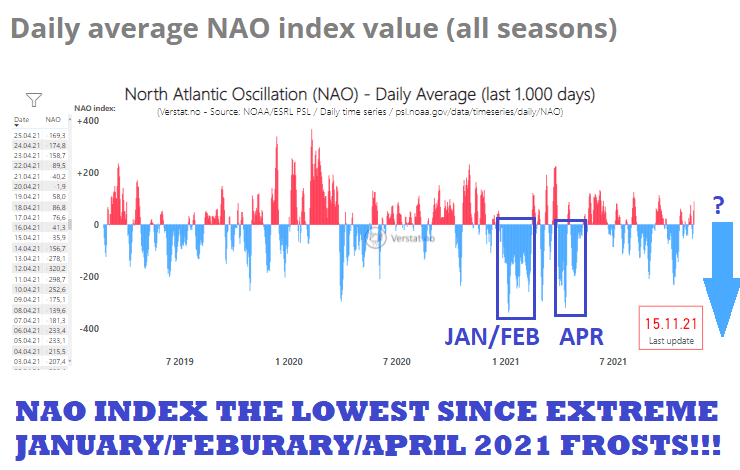
The next supporting parameter, which should mean extreme, regionally historic, late-November, and early-December 2021 coldwaves!
Averaged daily NAO index in the last November 2021 days is according to NOAA will drop up to -2.0, with a possible single daily record of around -2.5, which means the lowest values of the index since extreme frosts in January, February, or April 2021, when was Europe hit by legendary frosts!
Estimates we have marked in the equivalent of NAO index projection from server verstat.no and in a finding of similarly low values, such as expected (100-times ratio of scales) we returned back long 8 – 10 months!
Yes, the NAO index has at the end of November 2021 and in early December 2021 potential to be the lowest since legendary April 2021, when the temperature in Slovenian village Novi Vasi na Blokah at only 718 MASL minimum temperature dropped to -20,6°C! /some info on our old page: https://mkweather.com/european-april-arctic-blast-206c-in-718-masl//
Or, if the April NAO record will be overcome, it will be the lowest negative NAO index since historic frosts across Northern Hemisphere in January and February 2021 (Czechia or Hungary reported -35°C during the peaking of extreme coldwaves) /see our archive: https://mkweather.com/2021/04/page/2/; https://mkweather.com/2021/01//
Extremely low NAO index means very high potential for extreme frosts and blizzards across Europe, such as we warned in previous articles /https://mkweather.com/heavy-blizzards-hit-europe-in-these-regions-is-possible-snow-calamity/; https://mkweather.com/all-of-spain-under-frosts-attack-up-to-20c-half-of-iberia-under-the-snow-in-northern-africa-10c-is-possible/; https://mkweather.com/temperature-records-25c-and-up-to-1-meter-of-snow-in-france/; https://mkweather.com/central-europe-winter-should-start-with-historic-30c-in-frost-valleys-blizzards-and-snow-calamity-very-possible/; https://mkweather.com/historic-frosts-below-10c-in-london-20c-in-scotland-possible-all-uk-and-ireland-under-the-snow//.
AO- and NAO- situations should according to prognoses persist or at least return minimally until New Year 2022 /https://mkweather.com/winter-should-be-strengthening-until-new-year-2022-wider-european-region-estimates//, which means, that Mkweather seasonal forecasts from July 2021 about extremely cold start of Winter 2021/2022 will be successful /https://mkweather.com/winter-2021-2022-in-europe-should-start-very-early-nao-and-cold-airflow-are-predicted-2021-2022-winter//. Out latest Winter 2021/2022 forecast shifted a peak of winter in Europe to January 2022 /https://mkweather.com/winter-2021-2022-forecast-for-northern-hemisphere-an-awakening-solar-activity-la-nina-neutral-nao-ao-wet-mjo-and-iod-to-drier-mjo-and-iod-qbo-ne-pacific-warm-blob-aao//, but in the next days, Mkweather will publish a new winter forecast update.
According to the coldest outputs, -30°C frosts should be in the next weeks possible in the continental (central Europe – from France to Ukraine), below -35°C in Scandinavia or below -20°C in British Islands or Spain. Balkan isn´t sure, for now, because a possibility of warm pressure high is possible, according to fresh forecasts.
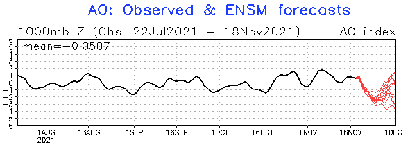
Meanwhile, the AO index is forecasted to drop only to -3, which isn´t so extreme hemispheric value, but still enough for an extreme cold blast across continents.
Mkweather will carefully watch the situation and in the case of breaking of historic temperature records, and anomalously low NAO index we will inform you on our homepage, soon.

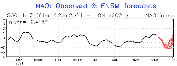
NAOi forecast. Source: https://www.cpc.ncep.noaa.gov/products/precip/CWlink/pna/nao.sprd2.gif

