NAO+ winters and NAO- summers? This year is different, similar such as 2010
Climate change is bringing changes in circulation patterns, including NAO (North Atlantic Oscillation).
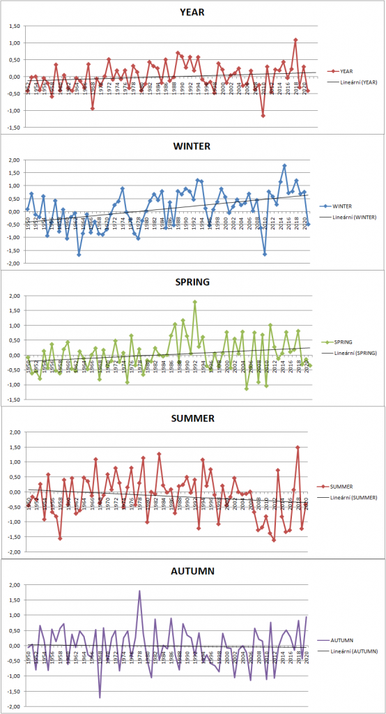
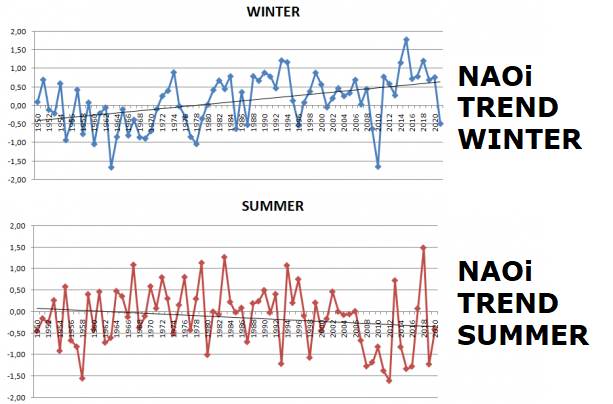
During last 72 years, since 1950, winters were becoming more NAO+, while summers were more NAO- during the time.
This trend has strengthened in last decade, mainly after year 2010, when all years brought NAO+ winter months. 11 summers after 2006 (until 2020) were on the other hand NAO-.
NAO+ in winter means very warm conditions for Europe and cold for parts of eastern Canada and Great Lakes region.
NAO- summers mean more strong heatwaves during the summer in Europe, however, if is index very low, it should mean many storms and extreme rainfall, too.
It is not fully clear, if the next summer will be NAO+ or NAO- : above Northern Sea is expected dry anomaly, while continental Europe should be more stormy.
Action center of NAO+ circulation pattern is however in summer westward from British Islands (not northward) – and it is Azores high, not cold Greenland high.
Year 2010 was interesting and brought NAO- in winter and summer both, year 2021 has more similarities just with 2010 – heatwaves in Russia, coldwaves in Europe, La nina pattern, solar cycle minimum (11-period cycle)…
The longest series of NAO- winters appeared between 1960 – 1970, while the longest series of NAO+ winters between 2011-2020.
Springs have tendency to becoming more NAO+, while autumns more NAO-. On autumn is interesting mainly October, with around 70% NAO- Octobers after 2000 thanks to Arctic change.
According to ECMWF, more NAO+ June and August and NAO- July, September and October (and NAO+ November) are in outlook – NAO- in July should be linked with expected peak of Summer 2021 between 10.-30. July in CFSv2 Mkweather experimental forecast /https://mkweather.com/experimental-cfsv2-forecast-for-summer-2021-in-europe-heavy-storms-short-peak-in-july-and-early-autumn-in-august-2021//.
NAO+ in summer means more stable weather for northern and western Europe and very stormy Mediterranean, mainly Balkan (see correlation map below). Continental Europe is during NAO+ in summer temperature stable, without bigger heatwaves, thanks to persisting NW airflow.
NAO- in summer is bringing low-latitudinal pressure lows above Azores, which will causing extreme tropical advections from Sahara above continental Europe on their front sides. However, British Islands, Scandinavia and NW European coasts are during NAO- colder and very stormy (oppositely such as NAO-).
Summer 2021 however will be in parts of Europe (mainly N,W and NW) colder in the case of NAO+ such as NAO-, thanks to La nina, solar cycle minimum and volcanic activity above average /https://mkweather.com/a-big-european-circulation-anomaly-in-2021-totally-oppositely-such-as-in-the-world-and-showing-what-climate-change-should-bring-until-2100/; https://mkweather.com/summer-2021-in-europe-will-be-colder-such-was-forecasted/; https://mkweather.com/the-next-cold-winter-strong-la-nina-in-winter-2021-2022-forecasted/; https://mkweather.com/2021-22-little-ice-age-years-with-volcanic-activity-in-last-30-years-had-tendency-to-be-la-nina-during-solar-cycle-minimum/; https://mkweather.com/2021-22-little-ice-age-years-with-volcanic-activity-in-last-30-years-had-tendency-to-be-la-nina-during-solar-cycle-minimum/; https://mkweather.com/the-coldest-spring-2021-in-europe-since-1987//.
72 / 71-year trends of seasonal values of NAO index (1950-2021/2020):
Correlation maps of NAO index and temperatures and precipitation in Europe /Blade, 2012:
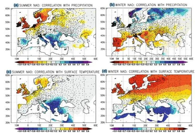
projected drying in the Mediterranean region, DOI: 10.1007/s00382-011-1195-x/