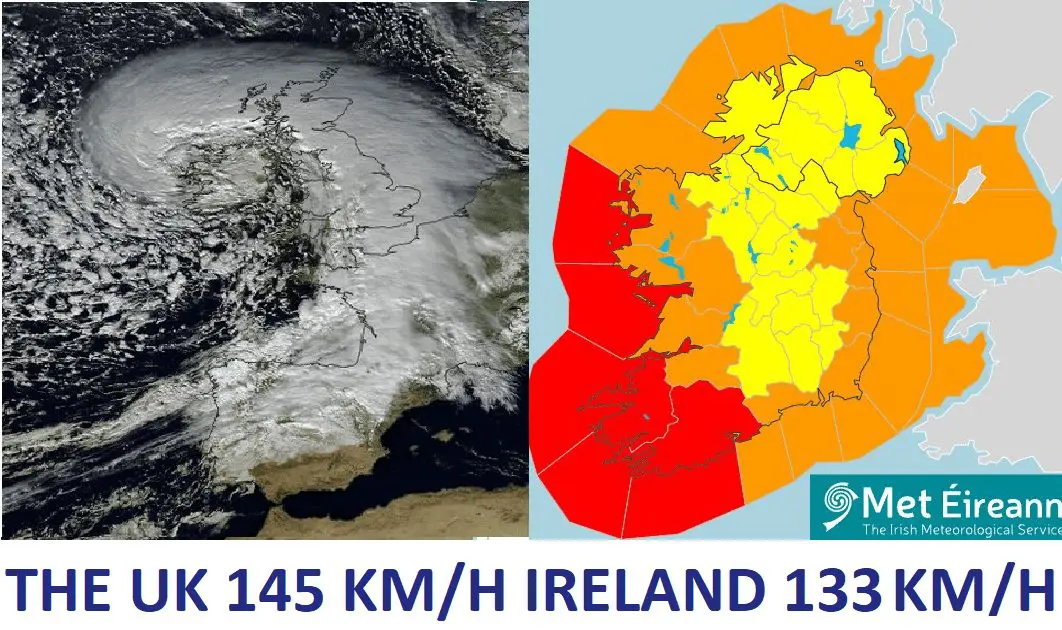
The worst windstorm since 2018! The UK 145 km/h, Ireland 133 km/h!
The most amount of red warnings since 2018!
Windstorm Barra brought in the UK and Ireland widespread problems, including power outages and limited outdoor activities.
Before a severe storm, we have warned in the previous article /https://mkweather.com/150-km-h-winds-in-british-islands-windstorm-barra-hits-the-uk-and-ireland//.
In regions elevated below 1000 MASL, wind gusts really up to 150 km/h have appeared:
In Cairnwell, 933 MASL, 145 km/h wind gusts were measured, while Aberdaron, only 95 MASL, reported 139 km/h wind gusts.
In Cairnwell, moreover, minimum temperatures near strong winds dropped to -5,3°C, which should mean real feel temperatures close to -20°C.
In Ireland, 133 km/h wind gusts were measured in Mace Head, 23 MASL and Sherkin Island, 5 MASL, Valentia Observatory reported 130 km/h.
The storm caused across British Islands around 60 000 power outages, fatalities aren´t fortunately reported.
The average wind gust based on this table for Barra with 105 kph was the highest since Ali in September 2018 which had an average of 106 kph, according to Twitter watchers.
Air pressure in the middle of the system dropped almost to 955 hPa and the system brought significant worsening of weather across the islands, with rain, snow, and low windchill.
Meanwhile, cyclones above the continent are more aggressive in the case of extreme snowfall events /https://mkweather.com/record-snow-in-pyrenees-france-spain-the-next-blizzards-are-only-coming/; https://mkweather.com/bratislava-should-surprise-40-cm-of-snowfall-the-metropolitan-city-is-preparing-for-snow-calamity/; https://mkweather.com/20c-in-austria-before-an-arrival-of-blizzard-20-30-cm-for-vienna-after-blizzard-will-be-even-colder/; https://mkweather.com/serbia-expects-extreme-blizzard-1-meter-snwofall-all-balkan-will-be-under-the-snow//.
Rare snowfall in the last days appeared even in Sahara, Algeria /https://mkweather.com/collapse-of-atmospheric-circulation-snowing-in-ain-sefra-sahara-algeria// and many historic temperature records across Northern Hemisphere were broken.
Only before a few hours have appeared the strongest early frosts in the Siberian coldest region in all-time history (-61,0°C) /https://mkweather.com/historical-times-for-siberia-610c-has-never-been-measured-so-early//.
In Canadian Arctic, frosts up to -46,0°C have appeared, so far – in many regions, it´s the strongest earliest frosts since 2004 /https://mkweather.com/eureka-431c-the-lowest-temperatures-in-canadian-arctic-in-early-winter-since-2004/; https://mkweather.com/canada-460c-daily-records-in-yukon-were-broken//.
In Europe, the strongest early frosts since 1945 have surprised Sweden (-43,8°C) /https://mkweather.com/the-strongest-early-frosts-in-the-baltic-region-in-62-years-since-1959-tartu-estonia-276c-zoseni-latvia-264c//, the strongest early frosts since 1959 Estonia (-27,6°C) /https://mkweather.com/the-strongest-early-frosts-in-the-baltic-region-in-62-years-since-1959-tartu-estonia-276c-zoseni-latvia-264c// and in valleys in continental Europe was measured -22,0°C so far /https://mkweather.com/220c-in-pontets-france//.
All after anomalously cold Arctic, with the 2nd highest Arctic Sea Ice Extent in the last 15 years /https://mkweather.com/arctic-sea-ice-extent-is-the-2nd-highest-in-15-years/; https://mkweather.com/20-vessels-stuck-and-ice-locked-in-northern-sea-route-the-arctic//.
Therefore, stay safe and warm and will be prepared for the next manifestations of severe winter.
#StormBarra will bring disruptive weather to Ireland on Tuesday and Wednesday, with impacts from severe, damaging winds as well as heavy rain. #Wind and #rain warnings are in place across Ireland ⚠️🍃☔️
— Met Éireann (@MetEireann) December 6, 2021
Read more in our #StormBarra news story 📰ℹ️ https://t.co/jZZxcE5Nup pic.twitter.com/dVL6MasdRA
La tempête #Barra vue par Meteosat-11 le 7 décembre à 12 h 30 UTC. Le corps de la perturbation recouvre presque toute la France, avec la pointe bretonne déjà en traîne. @meteofrance. pic.twitter.com/68UgG05Gyx
— Sylvain Le Moal (@SylvainLeMoal) December 7, 2021
Typical for a #windstorm (extratropical cyclone) is that the lowest pressures are reached just after the maximum windspeeds. Here are the lowest forecasted pressures for #Barra #StormBarra by 5 weather models.
— SRG SCIENCE 🏳️🌈 🇵🇸🇺🇦 (@ScienceSrg) December 6, 2021
ECMWF and ICON-EU: both 958hPa
CMC: 957hPa
ARPEGE: 956hPa
GFS: 955hPa pic.twitter.com/1IpFvF1NCd
This is the most amount of red warranted gusts since Storm Eleanor in January 2018. The average wind gust based on this table for Barra with 105 kph was the highest since Ali in September 2018 which had an average of 106 kph.
— Sryan Bruen (@SnowbieWx) December 8, 2021
@MetEireann has put out a Red Warning for SW #Ireland where wind gust could reach 130kph (80mph). #Barra could be a serious storm for those areas, especially for the western coast of Ireland. Impacts start this Tue. #StormBarra pic.twitter.com/oX25VbkGkQ
— Vortix (@VortixWx) December 6, 2021
European Windstorm Barra causes at least 56,000 power outages across the United Kingdom and Ireland. https://t.co/U7YOa0obQn
— Offstream News (@offstream_news) December 8, 2021


