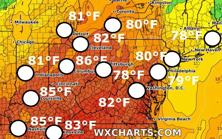
Mid-October heatwave in Northeast, the USA! Indian summer brought 86°F/+30,0°C in Columbus, 82°F/+27,8°C in Cleveland, 81°F/+27,2°C in Washington D.C., Detroit and Indianapolis, 80°F/+26,8°C in New York, Erie, 79°F/+26,2°C in Philadelphia, 78°F/+25,6°C in Providence, Pittsburgh
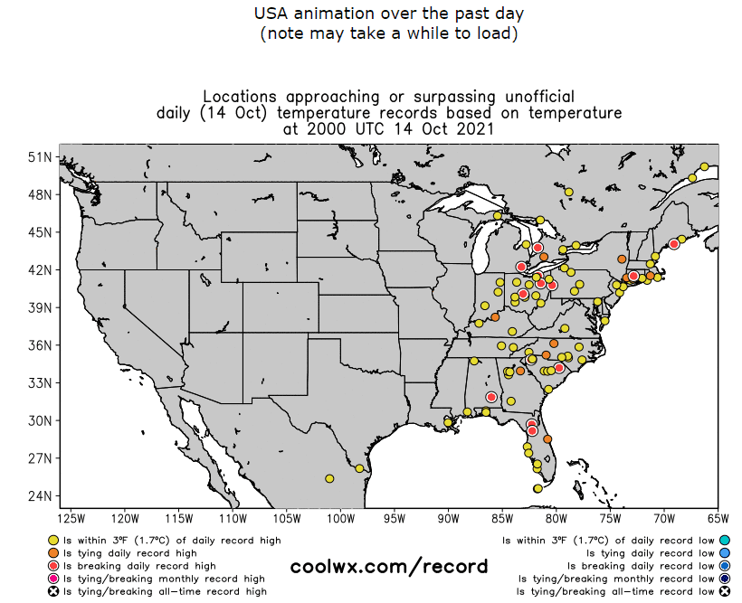
A peak of an anomalous heatwave in the Northeast was forecasted to Thursday and Friday, 14.-15. October 2021 and data from Thursday are already available.
Before Northeast, East Coast, Southeast, and Florida, summer and tropical days hit Midwest and Canadian Prairies /https://mkweather.com/extreme-indian-summer-in-the-usa-midwest-378c-100f-and-11-states-with-all-time-seasonal-records/; https://mkweather.com/it-has-never-been-so-hot-so-late-indian-head-saskatchewan-320c-a-new-october-temperature-record-estevan-saskatchewan-323c-brandon-manitoba-317c//.
Extremely hot +41,1°C / 106°F was measured before the arrival of remnants of Hurricane Pamela in Texas /https://mkweather.com/texas-411c-mexico-418c-before-the-arrival-of-hurricane-pamela-it-has-already-hit-the-land-severe-floods-in-texas-under-watch//.
On Thursday, the hottest in the Northeast (bigger metropolitan cities) was in Columbus, Ohio, +30,0°C / 86°F.
+27,8°C / 82°F was reported from Cleveland, +27,2°C / 81°F from Washington D.C., Detroit and Indianapolis.
New York reported +26,8°C / 80°F, similarly such as Erie near Great Lakes.
In Philadelphia, +26,2°C / 79°F, in Providence and Pittsburgh +25,6°C / 78°F was measured.
In Canada, the hottest was in Windsor near Great Lakes, +27,7°C / 82°F.
From other cities in Florida, Southeast, Mid-Atlantic or Northeast we should mention Orlando, Florida, with +32,2°C, Augusta, Georgia, +31,1°C, Montgomery, Alabama +30,6°C, New Orleans, Louisiana, +30,6°C, Charleston, South Carolina, +30,0°C, Wilmington, North Carolina, +30,0°C, Louiseville, Kentucky, +29,4°C, Nashville, Tennessee, +29,4°C, Newark, New Jersey, +27,8°C, Richmond, Virginia, +27,8°C, Baltimore, Maryland, +27,2°C, or Fort Wayne, Indiana, +27,2°C.
On Friday, 15. October, a heatwave should be peaking along the northeastern coast and in eastern Canada, and in the next period, anomalously warm air will shift above eastern and northern Canada.
Meanwhile, Texas and Midwest are after/before a hit of ex-Hurricane Pamela and western half of the USA and Canada after extreme cold blast /http://mkweather.com/seattle-with-the-coldest-october-day-since-1899-vancouver-since-1958/; https://mkweather.com/winter-came-to-the-usa-up-to-40-inches-1-meter-of-snow-is-forecasted//.
Warm anomaly above Canada will be associated with an Early Canadian stratospheric warming pattern, which should be linked with early winter conditions in Eurasia and later peak of Winter 2021/2022 in Canada and the USA (around February 2021) /more in Mkweather Winter 2021/2022 forecast: /https://mkweather.com/winter-2021-2022-forecast-extreme-frosts-in-eurasia-in-december-in-north-america-in-february-early-canadian-stratospheric-warming-ne-pacific-blob-la-nina-qbo-and-shift-from-nao-to-nao-such-le/; https://mkweather.com/winter-2021-2022-forecast-a-peak-near-nao-already-in-december-ne-pacific-warm-blob-nao-and-early-spring-in-february-north-america-oppositely-warm-start-cold-end-of-winter/; https://mkweather.com/russian-meteorologists-expect-extreme-winter-around-december-january-2021-22//.