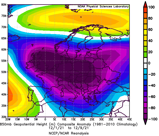
ESRL composites for early Winter 2021/2022 cold period in Europe, 25.11.-10.12.2021
An extremely cold period in Europe has in many parts of Europe already peaked and the next regions for the strongest frosts are only waiting.
In this article, we should look at some interesting plots from ESRL /https://psl.noaa.gov/data/composites/day//, revealing, how a character of the cold period really was.
While above continental Europe has shifted extremely low geopotential, which was associated with severe blizzards /https://mkweather.com/1-meter-of-snow-around-1000-masl-40-cm-in-lowlands-the-worst-blizzard-in-austria-since-the-legendary-winter-2012/; https://mkweather.com/ratece-slovenia-86-cm-snowfall/; https://mkweather.com/oberstdorf-germany-48-cm-snowfall/; https://mkweather.com/bratislavas-metropolitan-area-with-up-to-30-cm-snowfall-the-worst-blizzard-since-2013//, above northern parts of Europe and the partially Alps has shifted extremely cold air, with many temperature records /https://mkweather.com/the-worst-predictions-came-true-sweden-427c-the-lowest-temperature-in-naimakka-in-december-in-all-time-history/; https://mkweather.com/the-strongest-early-frosts-in-the-baltic-region-in-62-years-since-1959-tartu-estonia-276c-zoseni-latvia-264c/; https://mkweather.com/st-petersburg-210c-record-from-1893-was-broken-in-a-metropolitan-area-of-the-city-temperature-dropped-to-30c// + / https://mkweather.com/220c-in-pontets-france/; https://mkweather.com/20c-in-austria-before-an-arrival-of-blizzard-20-30-cm-for-vienna-after-blizzard-will-be-even-colder/; https://mkweather.com/combe-de-loscence-france-196c-in-975-masl/; https://mkweather.com/dobsinska-ladova-jaskyna-slovakia-180c-austria-168c/; https://mkweather.com/la-brevine-switzerland-180c/; https://mkweather.com/italy-314c-in-the-alps-and-178c-in-populated-areas/; https://mkweather.com/northern-italy-with-15c-in-lower-situated-areas-rare-snow-in-sicily-and-sardinia-forecast/; https://mkweather.com/grenoble-france-384-masl-100c-the-coldest-temperatures-in-the-region-minimally-in-the-last-50-years//.
The strongest negative temperature anomalies were observed above Scandinavia and the Baltic region, where regionally, the coldest first week since 1937 has appeared /a topic of the next Mkweather article/.
Cold air masses were gradually shifting slowly eastward and southward and the peak of frosts in parts of East-Central Europe, Eastern Europe, Italy, Balkan, Greece, or Turkey will only come, yet.
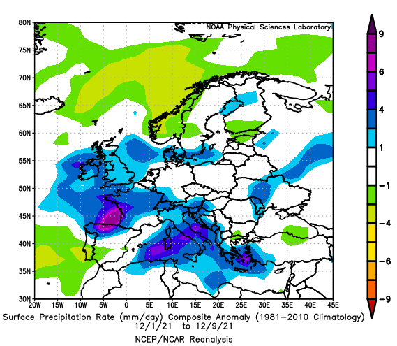
Precipitation above-average anomalies appeared in many parts of the Mediterranean, thanks to Mediterranean lows, but too in Western Europe and Alpine region (windstorms Arven and Barra in British Islands: https://mkweather.com/a-snowstorm-trapped-60-people-in-uk-pub-they-had-fun-and-sang-for-three-days/; https://mkweather.com/the-worst-windstorm-since-2018-the-uk-145-km-h-ireland-133-km-h/ + the Mediterranean and Genoa lows).
During the next 6 weeks, the next coldwaves, especially around Christmas 2021 and New Year 2022, are forecasted /https://mkweather.com/ecmwf-6-week-forecast-for-europe-until-24-january-2022//, which should bring even colder outputs from ESRL and peaks of winter in European mid-latitudes and the Mediterranean.
ESRL outputs will be updated after the end of the current coldwave and then during the winter holidays on Mkweather as soon as possible.
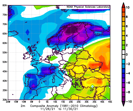
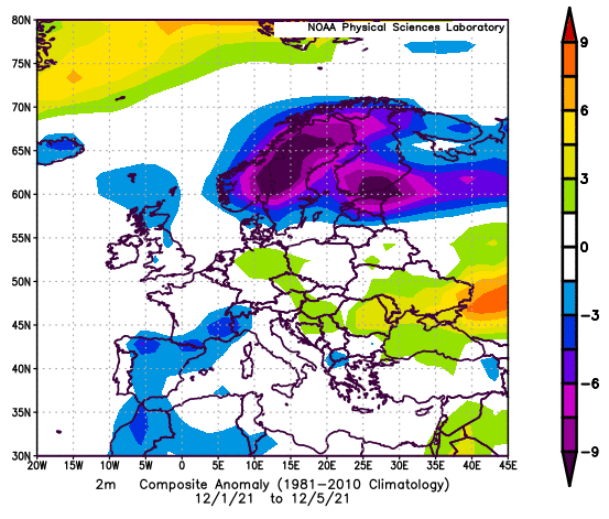
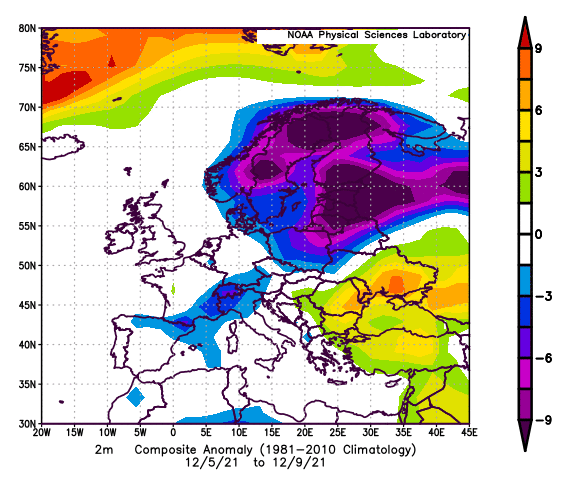
Temperature anomalies per pentads, 26.-30.11., 1.-5.12. and 5.-9.12. 2021 /Source: https://psl.noaa.gov/data/composites/day/


