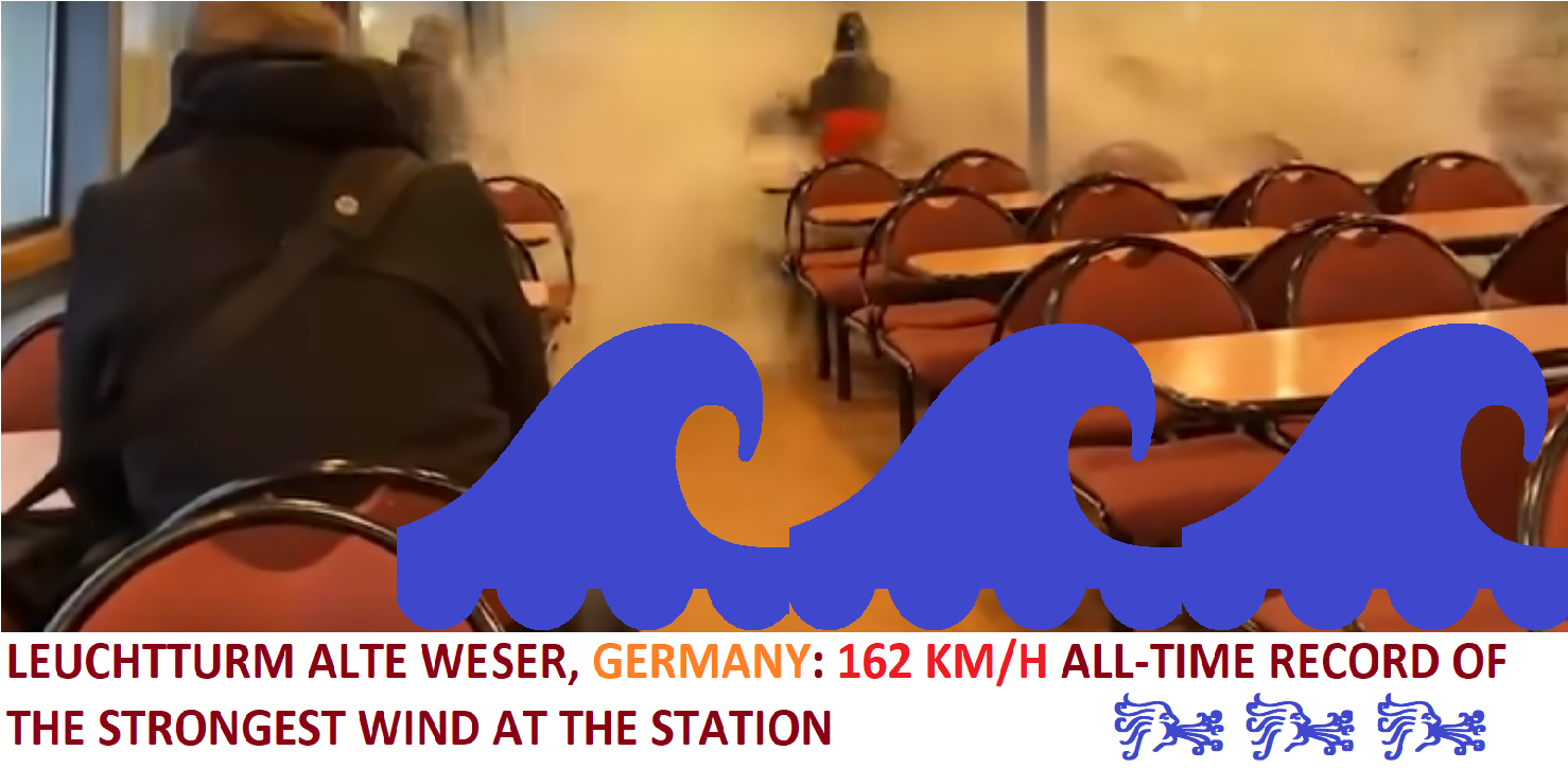
A vacation on the Elbe river, near Hamburg, northern Germany, changed to a horror scene when extreme 3-digit winds caused on the river anomalous waves, which trashed windows on the ferry and scared passengers.
Large parts of Europe hit on Friday and Saturday Windstorm Eunice, which brought, e.g., England, the strongest wind gusts in all-time history, up to 196 km/h in lower elevated areas /https://mkweather.com/severe-windstorm-eunice-hits-nw-europe-with-wind-gusts-100-140-km-h-rarely-180-km-h/; https://mkweather.com/stronger-as-in-the-worst-nightmare-england-hit-the-strongest-winds-in-history-196-km-h-in-lower-situated-areas-10-dead-rotterdam-130-km-h-frankfurt-123-km-h//.
Only shortly before, the next windstorm, Dudley, brought a deadly tornado outbreak in Poland /https://mkweather.com/5-destructive-tornadoes-hit-poland-injured-people-and-destroyed-homes-the-strongest-should-have-the-power-of-ef2/; https://mkweather.com/the-next-bad-news-from-poland-tornado-hit-krakow-2-dead-2-injured//.
At the station, Lechtturn Alte Weser, northern Germany, wind gusts reached on Friday, 18. February 2022 record value of 162 km/h, which is the highest wind gust measured in one of the windiest stations in the country.
In Munster, only 3 km/h was missing to all-time wind gust record (123 vs. 126 km/h), or in Hamburg, only 7 km/h was missing to all-time highest value (123 vs. 130 km/h). In Lindenberg, it was only 2 km/h (120 vs. 122 km/h).
Hamburg alone reported 101 km/h, similarly such as Berlin.
From other stations in the winder region, Snezka / Sniezka (Czechia / Poland) reported 187 km/h, Leuchtturm Alte Weser (Germany) 162 km/h, Brocken (Germany) 151 km/h, Cabauw Tower (the Netherlands) 144 km/h, Gedser Odde (Denmark) 135 km/h, Arkona (Germany) 133 km/h, Dieppe (France) 133 km/h, Boulogne (France) 130 km/h, Rotterdam (the Netherlands) 130 km/h, Dunkerque (France) 130 km/h, Amsterdam (the Netherlands) 126 km/h, Plymouth (the UK) 124 km/h, Frankfurt (Germany) 123 km/h, Muenster (Germany) 123 km/h, Petrobaltic Beta (Poland) 123 km/h, Bremen (Germany) 119 km/h, Koeln (Germany) 115 km/h, Le Havre (France) 115 km/h, Antwerpen (Belgium) 112 km/h, De Bilt (the Netherlands) 112 km/h, Hannover (Germany) 112 km/h, Potsdam (Germany) 112 km/h, Sulejow (Poland) 112 km/h, Kramolin – Kosetice (Czechia) 112 km/h, Exeter (the UK) 111 km/h, Duesseldorf (Germany) 108 km/h, Kittila (Finland) 108 km/h, Klodzko (Poland) 108 km/h, Rax (Austria) 108 km/h, Diepenbeek (Belgium) 105 km/h, Gdansk (Poland) 105 km/h, Nurnberg (Germany) 105 km/h, Hasvik – Sluskfjellet (Norway) 101 km/h, Leipzig (Germany) 101 km/h, Rostock (Germany) 101 km/h, Sczecin (Poland) 101 km/h.
After windstorms, only relatively colder weather is forecast and already at the end of February and early March 2022, the next early-spring heatwave is predicted /https://mkweather.com/the-first-heatwave-of-the-summer-season-will-come-very-early-26-2-5-3-2022-the-mediterranean-30c-continental-europe-25c-british-islands-scandinavia-up-to-20c//.
Meanwhile, around 2-3 weeks in outlook until early April 2022 will have a potential for windstorms and tornadoes in northern parts of continental Europe /https://mkweather.com/ecmwf-6-week-forecast-for-europe-until-4-april-2022-extremely-warm-and-windstorms-and-tornadoes-possible-more-than-was-predicted//.
Strong Icelandic cyclone and Azores high both should be continuing thanks to a persisting NAO+ phase until the end of March 2022 /https://mkweather.com/nao-leading-pattern-minimally-until-1-april-2022//.
Then, colder April and May 2022 should appear, with some Arctic blasts and more storms /https://mkweather.com/hot-and-dry-march-cold-and-stormy-april-and-may-long-term-forecast-for-europe-sees-a-return-of-cold-and-weather-patterns//.

Illustration picture: The Telegraph Youtube


