Already in the last article, we offered a new outlook for Spring 2022 months from CFS /https://mkweather.com/hot-and-dry-march-cold-and-stormy-april-and-may-long-term-forecast-for-europe-sees-a-return-of-cold-and-weather-patterns//, with forecast extremely warm and dry conditions in March 2022 near NAO+, while April and May 2022 should be colder, with late-season frosts of a stormy pattern (Mediterranean lows) thanks to more often NAO- phases.
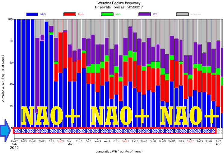
According to the newest ECMWF 42-day forecast until 3. April 2022, a leading strong NAO+ pattern is forecast, which means continuing conditions so-called such as “early spring” conditions, which hit parts of Europe since late January 2022 (in late January 2022, the first warm spells in western and southwestern Europe appeared).
In February 2022, extremely warm conditions are spreading into continental Europe and many other parts of the continent /https://mkweather.com/spain-259c-france-241c-austria-215c-hungary-201c-serbia-198c-bosnia-194c-slovakia-181c/; https://mkweather.com/nao-heatwave-is-bringing-summer-france-248c-spain-280c-morocco-321c-western-sahara-331c/; https://mkweather.com/early-spring-weather-is-coming-switzerland-214c-spain-267c-morocco-298c//, with the next expected warm spells/heatwaves at the end of February and early March 2022 /https://mkweather.com/the-first-heatwave-of-the-summer-season-will-come-very-early-26-2-5-3-2022-the-mediterranean-30c-continental-europe-25c-british-islands-scandinavia-up-to-20c//, although, very strong Icelandic low (thanks to NAO+) is bringing severe windstorms and tornadoes into northern parts of Europe /https://mkweather.com/severe-windstorm-eunice-hits-nw-europe-with-wind-gusts-100-140-km-h-rarely-180-km-h/; https://mkweather.com/5-destructive-tornadoes-hit-poland-injured-people-and-destroyed-homes-the-strongest-should-have-the-power-of-ef2/; https://mkweather.com/the-next-bad-news-from-poland-tornado-hit-krakow-2-dead-2-injured/; https://mkweather.com/mlada-boleslav-czechia-scared-a-tornado-tornadoes-should-appear-in-the-north-sea-and-baltic-sea-region-until-the-end-of-march-2022//.
March 2022 will be according to the newest ECMWF outputs exclusively NAO+, NAO+ leading pattern is namely predicted until 1. April 2022, with shorter breaks lasting more than 2 months.
Early spring heatwaves in March 2022 will be therefore very possible, with the first +30°C in parts of the Mediterranean (mainly Iberia, maybe Italy) and +25°C in continental Europe (from France to Ukraine).
Meanwhile, in the British Islands, Scandinavia, and Baltic region, the next severe windstorms and stormy NAO+ pattern is predicted, with many strong Icelandic cyclones, severe winds, and possible tornadoes and waterspouts in the North Sea and Baltic Sea region.
Late-season frosts and snowing in April 2022, after a decline of the NAO index will be in around 5-6 weeks during April, maybe early May 2022, still possible.
