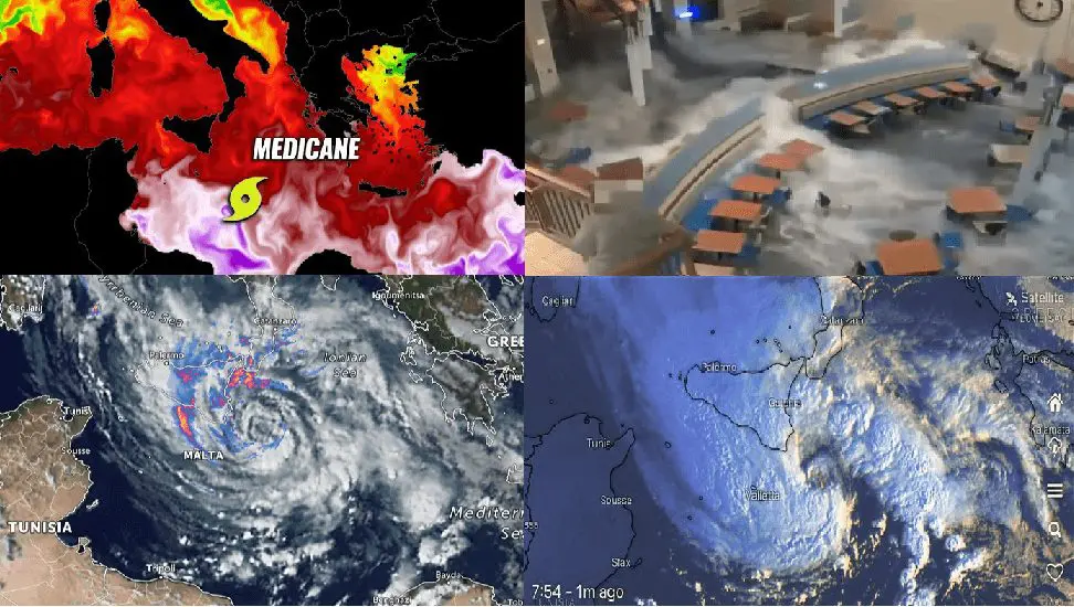
A Medicane Gloria (Apollo) re-strengthened and hit Italy and Libya, Siracusa 289 mm / 72 hours (annual amount of rainfall)!
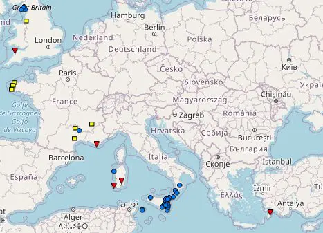
In the last week, we were informed about a powerful medicane, which in the last days hit Spain, Algeria, Tunisia, and Italy and brought extreme floods, with minimally 7 dead /https://mkweather.com/7-dead-after-a-devastating-medicane-in-algeria-tunisia-and-italy-320-mm-of-rain-in-linguaglossa-sicily-246-mm-in-ain-benian-algeria-and-136-mm-in-kalaat-andalous-ariana-tunisia/; https://mkweather.com/floods-in-algeria-and-spain-the-mediterranean-low-is-shifting-above-tunisia-italy-and-libya// and daily rainfall up to 320 mm (Italy), 246 mm (Algeria) and 136 mm (Tunisia) and floods in Alicante and Valencia regions, Spain appeared ,too.
In the last days, Medicane Gloria (Apollo) re-strengthened, and in Libya and Italy has brought the next severe floods.
In Syracusa, Sicily – the city received half of its average annual rainfall in 3 days.
Rainfall amounts this week reached 289 mm / 72 hours and the city, such as parts of Sicily, southern Italy and eastern Libya found themselves completely underwater.
Floodwater flooded a regional university in Catania, too – a stream of water invaded into an empty auditorium very aggressively, such we should see on the video in Tweet below.
193 mm surprised on 30. October in Villefort, France, too.
In Corsica, Rhodos, and southern France, 4 tornado reports were even recorded on ESWD /https://eswd.eu//.
Floods thanks to the arrival of the polar vortex have already appeared in England, Scotland, and Wales //the next Mkweather article/.
The polar vortex will be shifting in the next period above Europe, and gradually, after very hot times /https://mkweather.com/31-october-brought-temperature-record-325c-in-spain/; https://mkweather.com/november-heatwave-hits-europe-germany-25c-france-30c-spain-33c/; https://mkweather.com/any-extreme-frosts-ukraine-romania-or-serbia-with-abnormal-28c-around-5-november/; https://mkweather.com/34c-italy-33c-turkey-31c-greece-28c-romania-27c-croatia-and-ukraine-in-november/; https://mkweather.com/austria-with-anomalous-243c-indian-summer-in-central-europe-has-started-to-peaking//, a powerful coldwaves lasting several weeks are approximately between 5. November – 15. December 2021 forecasted /https://mkweather.com/extreme-coldwaves-in-continental-europe-confirmed-ensembles-cold-weather-should-be-lasting-up-to-45-days-with-a-peak-around-20-november-10-december-2021-mkweather-estimates/; https://mkweather.com/the-6-week-daily-forecast-for-the-wider-european-region-from-gismeteo-until-5-december-2021/; https://mkweather.com/be-prepared-for-an-extremely-long-and-strong-coldwave-arctic-blasts-in-europe-between-10-november-15-december-are-expected/; https://mkweather.com/winter-will-come-earlier-than-was-forecasted-30c-in-scandinavia-20c-in-central-europe-and-10c-in-british-island-around-10-november-is-possible//.
Severe frosts should be peaking around early Winter 2021/2022 /https://mkweather.com/winter-2021-2022-forecast-for-europe-early-extreme-arctic-and-siberian-blasts-and-blizzards-late-dry-and-very-warm-conditions/; https://mkweather.com/winter-2021-2022-forecast-extreme-frosts-in-eurasia-in-december-in-north-america-in-february-early-canadian-stratospheric-warming-ne-pacific-blob-la-nina-qbo-and-shift-from-nao-to-nao-such-le/; https://mkweather.com/winter-2021-2022-forecast-chances-for-white-christmas-2021-are-higher-than-usual-a-hope-for-nao-and-return-of-winter-conditions-in-february// and at the end – we have good news – with the end of winter (February or March 2022) it looks preliminary very good, too!