Winter 2021/2022 is coming and we are bringing continental updates of predicted patterns for Europe, North America, Asia, Africa (Winter + Summer 2021/2022), Australia (Summer 2021/2022), and South America (Summer 2021/2022).
In the last articles we looked at forecasted Winter 2021/2022 conditions in Europe /https://mkweather.com/winter-2021-2022-forecast-for-europe-early-extreme-arctic-and-siberian-blasts-and-blizzards-late-dry-and-very-warm-conditions// and North America /https://mkweather.com/winter-2021-2022-forecast-for-north-america-a-peak-of-winter-with-extreme-arctic-blasts-and-blizzards-in-february-2022//. Now, we should look at Asia.
Such as we detailed analyzed in the last Winter 2021/2022 forecast for the Northern hemisphere / https://mkweather.com/winter-2021-2022-forecast-extreme-frosts-in-eurasia-in-december-in-north-america-in-february-early-canadian-stratospheric-warming-ne-pacific-blob-la-nina-qbo-and-shift-from-nao-to-nao-such-le/ /, and Mkweather Winter 2021/2022 forecast for Europe /link above/, 9 main circulation patterns and important parameters will be affecting conditions during an upcoming winter:
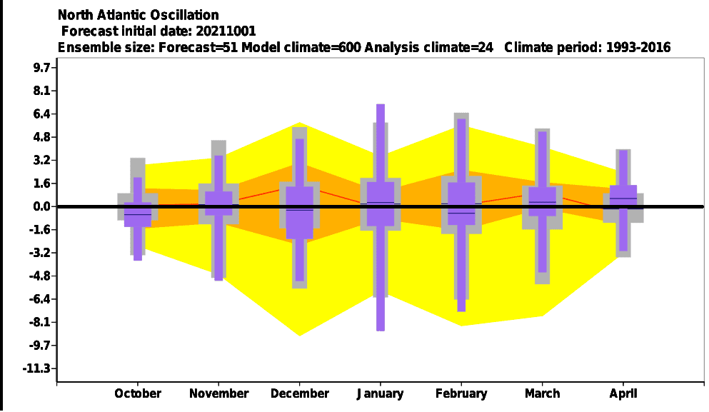
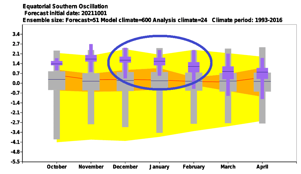
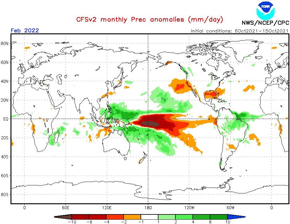
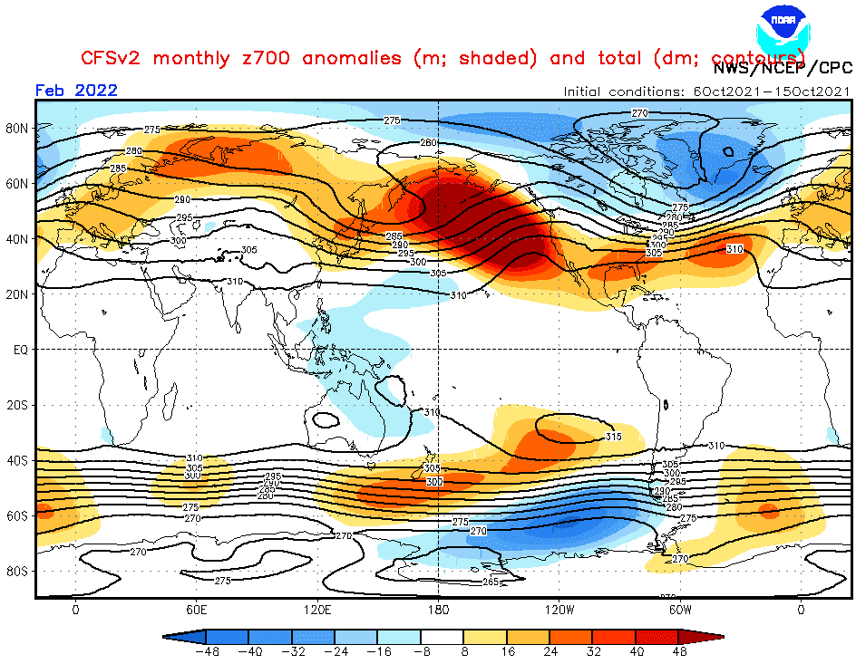
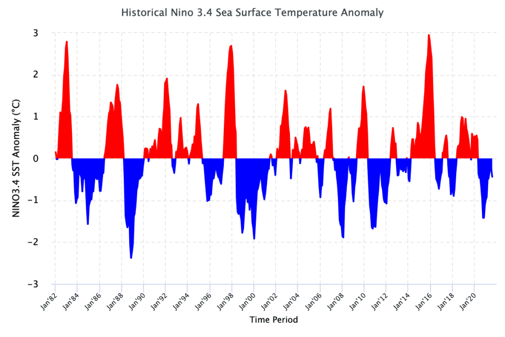
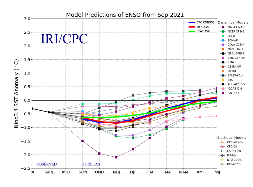
- Still low solar activity: We are still after a solar minimum, at the beginning of a 25. solar cycle, with a weaker predicted solar cycle. Weaker solar cycles were in the last centuries associated mainly with El-nino phases, but El-nino, maybe with a Godzilla character, is currently forecasted only for Autumn 2022 and years 2023, 2024 and maybe 2025 /https://mkweather.com/2022-2023-forecast-chances-for-el-nino//. An usual configuration of La nina conditions (Little Ice Age = low solar activity = El nino = NAO- and AO- and for high solar activity /stronger sun cycles/, La nina and NAO+ and AO+ more usual) will be set in January and February, with NAO+/AO+ conditions, with a weakening of winter conditions across many parts of Asia until the end of winter.
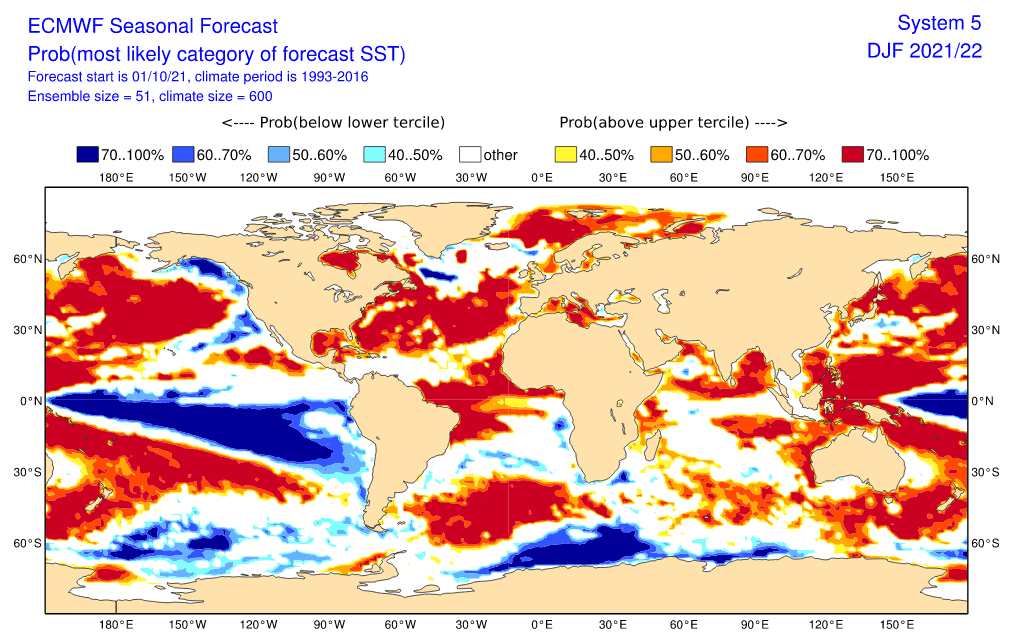
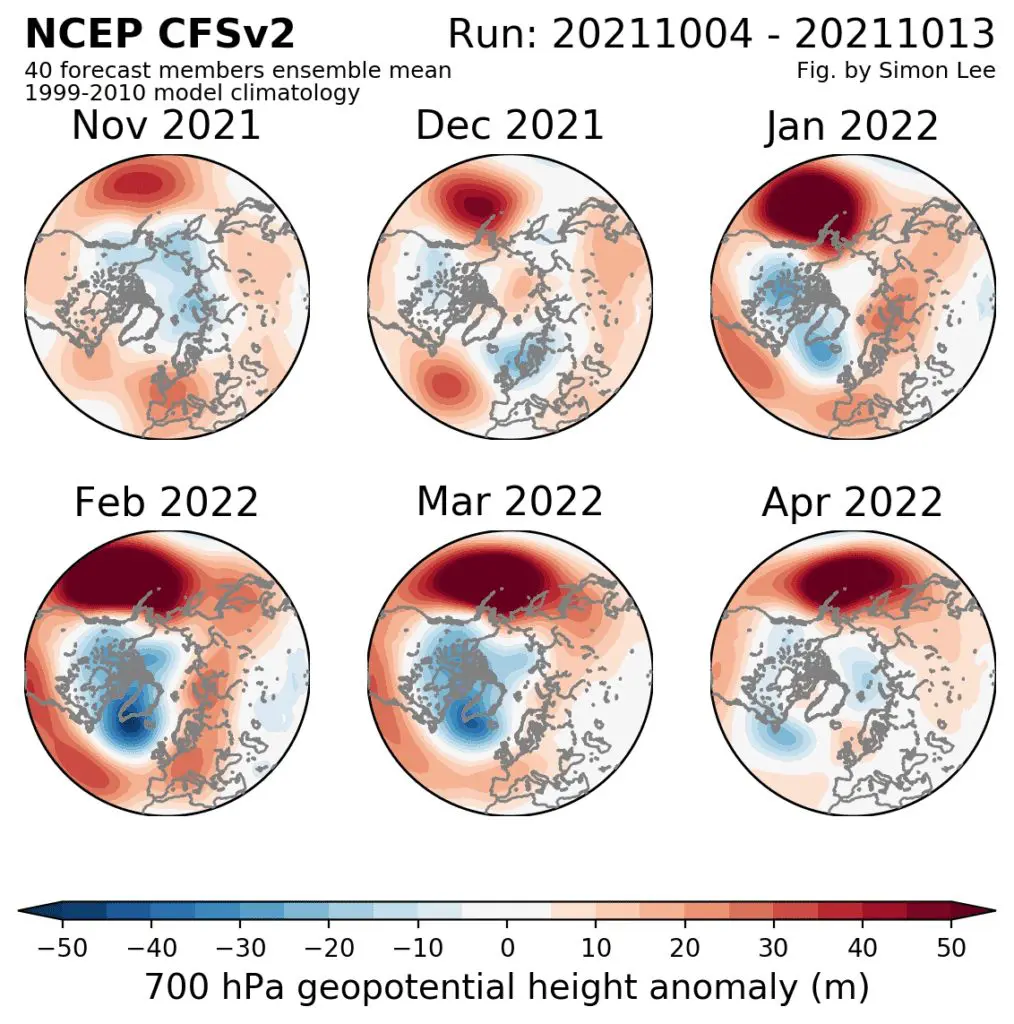
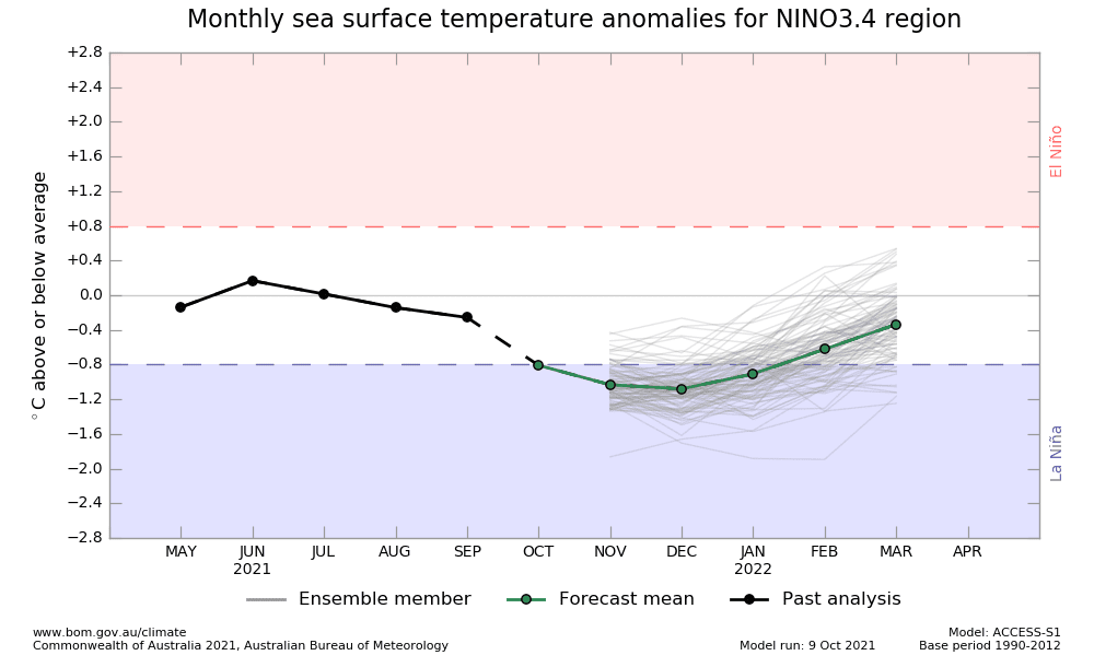
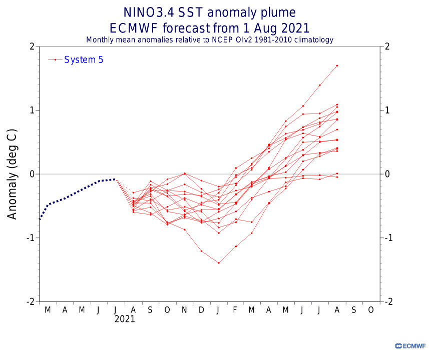
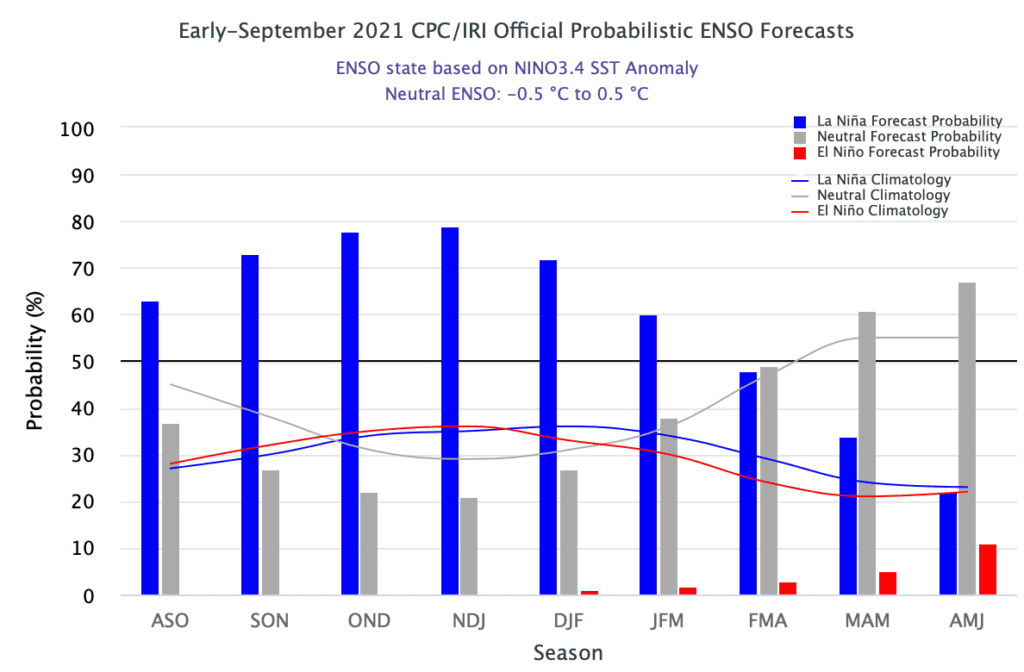
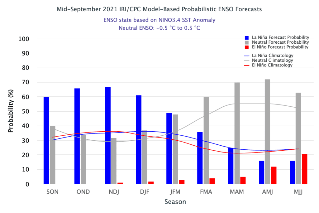
- Re-strengthening La Nina pattern: La nina in previous winter, Winter 2020/2021 in combination with record high pressure above Mongolia and record low pressure above Aleutian region at the same time causes extreme Major SSW, with a long-lasting coldwaves spreading from Asia to other continents. A reason of colder conditions in mid-latitudes in Asia should be mainly predicted NAO-/AO- phases forecasted for the first half of Winter 2021/2022. Meanwhile, La nina in monsoon Asia is linked with mostly very stormy patterns, with combinations with MJO and IOD, while El nino is in monsoon Asia very dry, with weak harvest /https://mkweather.com/2022-2023-forecast-chances-for-el-nino//
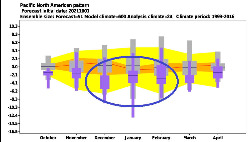
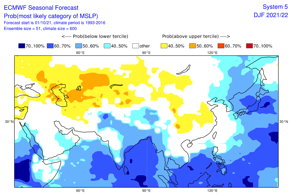
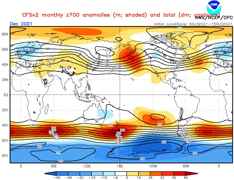
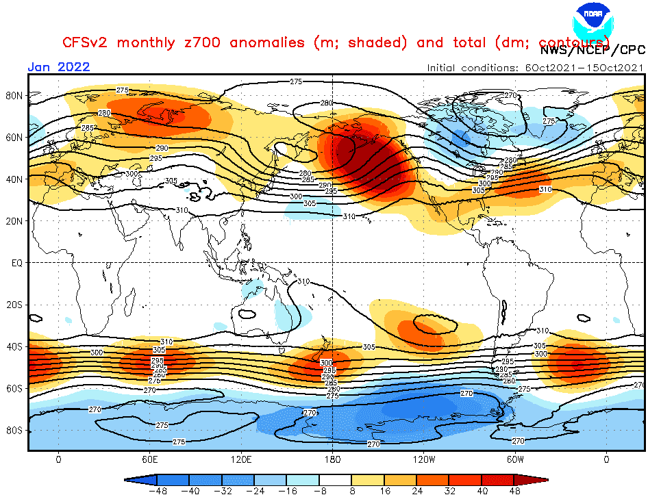
- Switch from NAO- / AO- to NAO+ / AO+ during Winter 2021/2022: The first half of Winter 2021, with dominant neutral or NAO- phases, should bring extreme cold blasts and blizzards (in southern region of the Middle East and India so called “Western disturbances”) across the continent, while the second half should be already AO and NAO positive, with a belt of very dry and warm weather across mid-latitudes, however with regional colder nights in subtropical climate zone. Therefore, the peak of Winter 2021/2022 is similarly such as in Europe and North Africa, expected in the first half of winter, so far. Siberia should be during this cold pattern drier and colder and mid-latitudes and southern climate zones should experience with periodic cold blasts with frosts or snowfall (in the south ground frosts and rain).
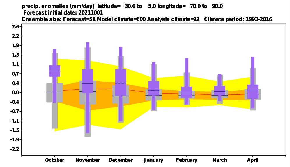
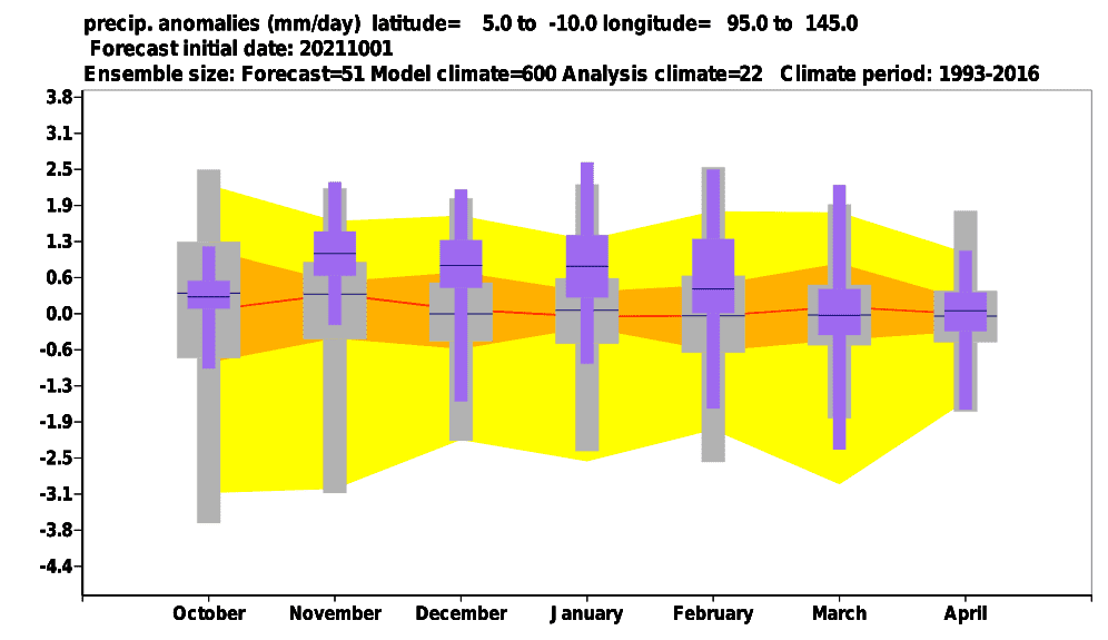
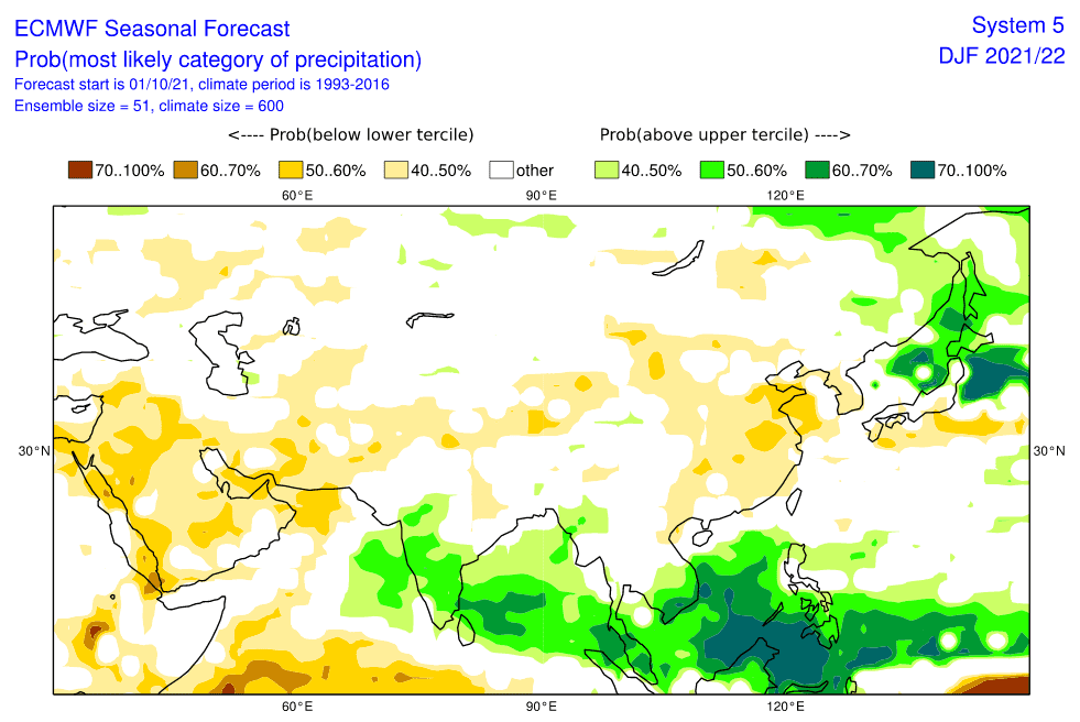
- Wet MJO above Southeastern Asia – Phases 4-7 correlate with NAO-/AO-: Anomalously stormy conditions above Southeastern Asia should persist mainly in the first half of Winter 2021/2022 – NAO- and AO- phases namely strongly correlate with MJO phases 4-7, phases, which are bringing extreme rainfall, floods and landslides into Southeastern Asia. Situation with floods should be calmer during a weakening of MJO and the shift of NAO/AO to their positive phase in January and February 2022. Together with La nina, wet MJO is bringing very stormy, but fertile times to many parts of monsoon Asia, maybe excluding China, Korea and southern Japan.
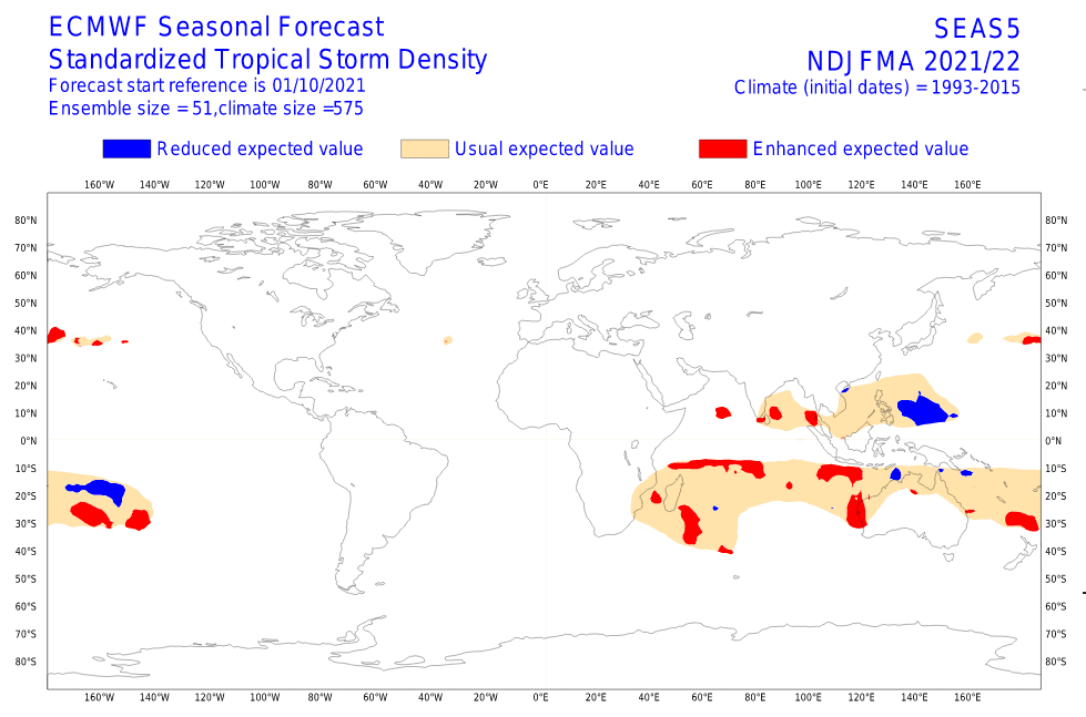
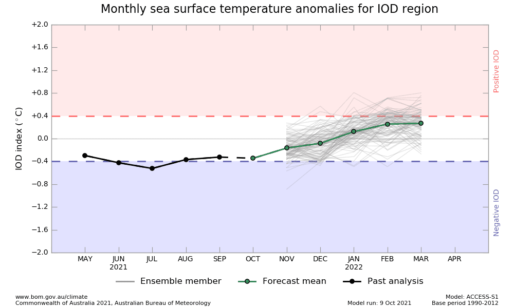
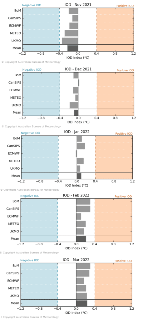
- IOD (Indian Ocean Dipole) shift from negative to positive phase: IOD is forecasted to shift from its negative to its positive phase during Winter 2021/2022, what means, that early winter should bring in eastern Indian Ocean region very stormy conditions, together with wet MJO and La nina, while western Indian Ocean will be anomalously hot and dry (Middle East). Positive IOD in late witner should be linked with calmer conditions, and weakening activity of tropical cyclones in eastern Indian Ocean (SE Asia, E India,…) and a shift of tropical activity into western Indian Ocean (W India, Oman, Yemen,…).
- QBO in Easterly phase: Although QBO is forecasted to stay in a colder phase until the end of Winter 2021/2022, other teleconnections will have probably a stronger impact on weather in Northern Hemisphere. This teleconnection however should contribute to relatively good character of winter in many regions.
- Early Canadian Stratospheric Warming – Legendary December frosts not excluded: Around November, the Early Canadian Stratospheric Warming pattern is expected. This anomaly was in the past often associated with a subsequent NAO- / AO- around December and possible legendary winters in Eurasia /https://mkweather.com/russian-meteorologists-expect-extreme-winter-around-december-january-2021-22//.
- NE Pacific Warm Blob Anomaly – NAO+ regime for the second half of winter?: This anomaly above Northern Pacific correlates with NAO+ conditions. Both regimes are forecasted to persist in January and this circulation should be peaking around February 2022, with very warm conditions in Eurasia and North Africa. Stronger NE Pacific Warm Blob therefore means a weakening of winter conditions across the continent.
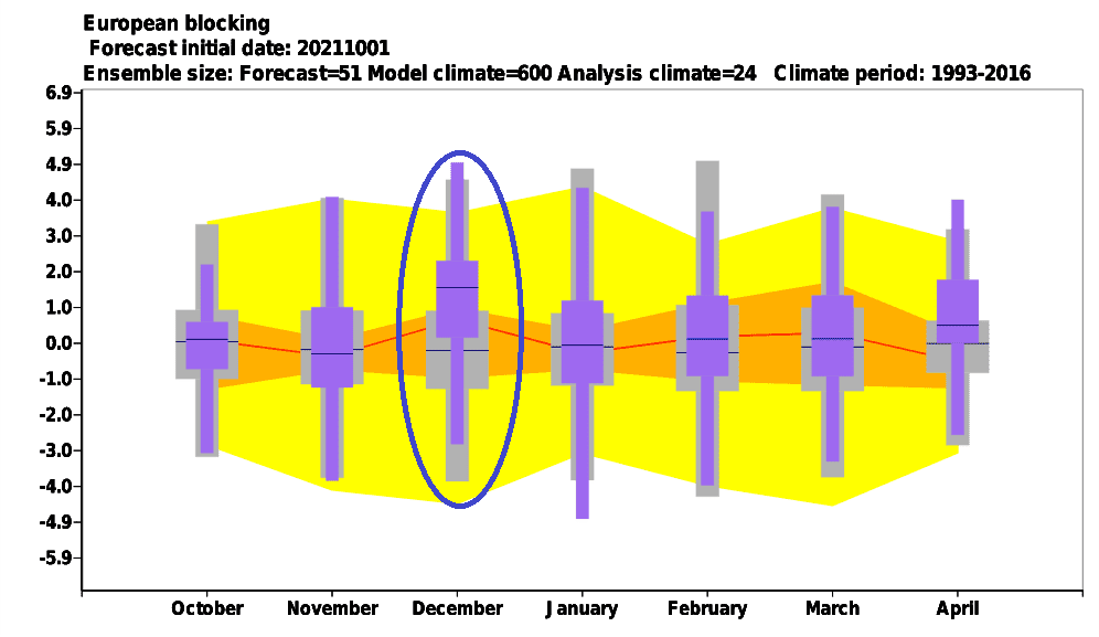
- Major SSW (Major Sudden Stratospheric Warming) already in the first half of Winter 2021/2022: The last, very important factor is, if there are chances for so-called “destabilization of polar vortex”, strongly associated with AO- / NAO- phases across Northern Hemisphere and severe cold blasts in mid-latitudes. Yes! A probability of SSW will be here just during the first half of Winter 2021/2022. Firstly, warm air from Canada should shift above the Arctic, where sometimes around December 2021, the collapse of polar vortex should become, with subsequent severe frosts firstly in European, Asian and North-African sectors. A response to a potantial collapse of polar vortex in Asia should bring an expected early peak of Winter 2021/2022 in Eurasia.
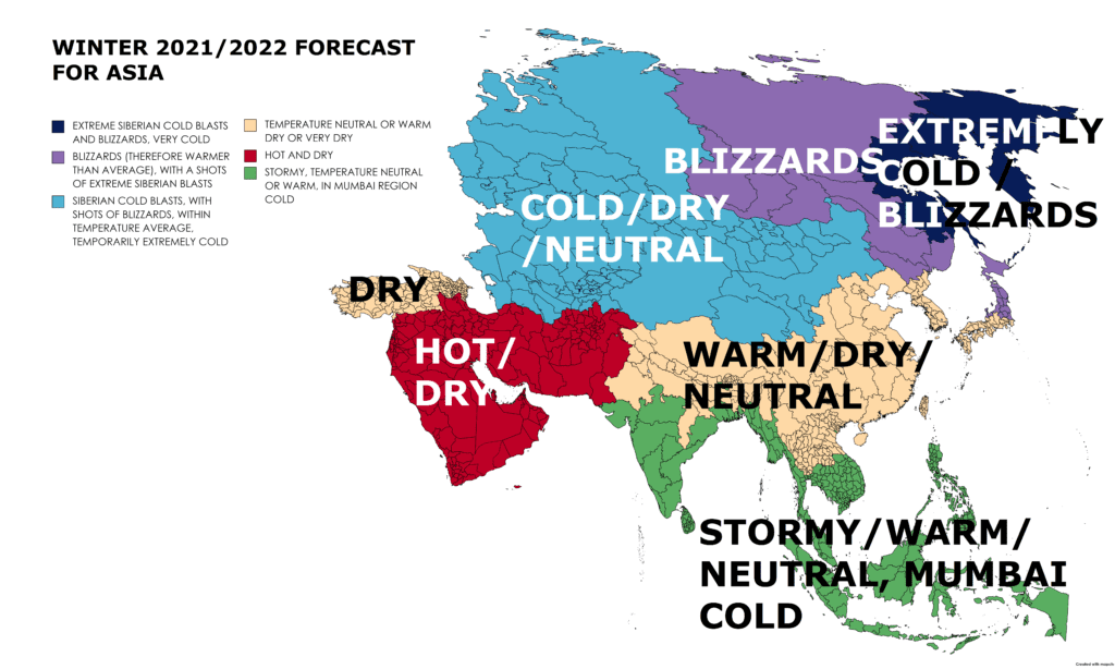
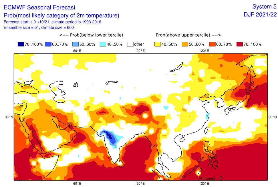
Now, we should look at a forecasted map for Winter 2021/2022 for Europe and 6 main sectors, with similar regimes of weather:
A) FAR EAST: A region appears such the coldest, with many Siberian cold blasts and blizzards during the upcoming winter, with the strongest negative temperature anomaly, mainly along the coast. The region will traditionally draw cold air from Eastern Siberia and Yakutia region simultaneously with escaping moisture from the warming Arctic. Frosts should be stronger in the first half of winter and blizzards in the second half of winter, thanks to the shift from NAO- (AO-) to NAO+ (AO+). Minimum temperatures up to -60°C in continental parts will be still possible.
B) EASTERN SIBERIA: Warm winter, but with many extreme blizzards is forecasted for Eastern Siberia. Escaping moisture from the warming Arctic will cause, that in some regions should fall during the upcoming winter 2x or maybe 4x more snow than is average. Thanks to NAO-/AO-, however, in the first half of winter, according to Russian meteorologists /link above/ in early January 2022, should appear a peak of winter with extreme Siberian frosts, up to -65°C. All will be strongly associated with conditions of the polar vortex – southern and weak polar vortex means drier and extremely cold conditions, while northern and strong polar vortex means warm conditions and blizzards.
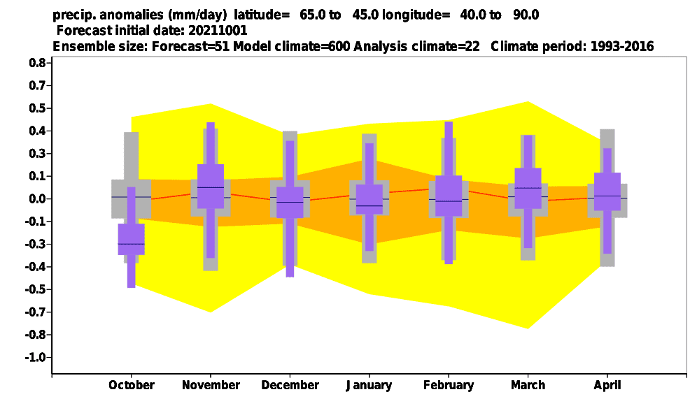
C) WESTERN WIBERIA, CENTRAL ASIA: A longer time it appears, that above Western Siberia should develop, mainly during the first half of winter, a polite stock of very cold air, with cold blasts not only in Europe but too in Central Asia, NW China or Mongolia. Relatively dry or neutral conditions above the region should mean fewer blizzard conditions and more chances for Siberian blasts. Thanks to NAO-/AO-, frosts should hit the region already in December, with a peak possibly around late December 2021 or early January 2021. NAO+/AO+ in the next period (late winter) should bring warmer conditions and more western airflow, in southern parts (Central Asia) even summer temperatures (above +25°C). During the peak of the winter, however, temperatures should drop up to -55°C in Siberian and very deep below zero in Central Asia.
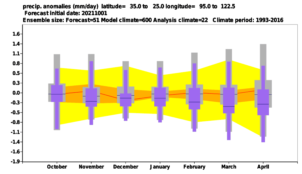
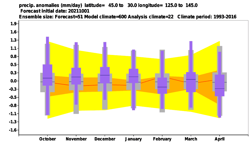
D) EAST ASIA, HIMALAYAN REGION, TURKEY, AND CAUCASUS: Dry monsoon-like conditions are forecasted in East Asia, northern India, northern continental SE Asia, and dry conditions should hit Turkey and Caucasus. Relatively better winter conditions in this region should come in the first half of Winter 2021/2022, too, with cold blasts across East Asia and Western disturbances in India, with a possible peak of winter (severe frosts in China, Korea, and Japan, ground frosts, fogs and precipitation in northern India). Turkey should be cold and warm both, thanks to alternating cold air masses from Siberia and hot air masses from the Middle East, very dry weather however should mean cold nights and severe frosts. The second half of winter in East Asia and northern India and SE Asia should bring premature heatwaves and drought. In East Asia, Turkey, and the Caucasus, frosts below -30°C should surprise in late December / Early January, but at the end of winter, summer +25°C should be measured; in India and northern SE Asia, temperatures in early winter should drop up to 0°C, but late winter promises the first tropical +30°C. AO/NAO will have probably a stronger impact on East Asia such as La Nina, MJO. In India, a shift from negative to positive IOD means to shift in tropical activity from the Bay of Bengal to the Arabian Sea coast, but northern India will be hit by tropical systems only marginally.
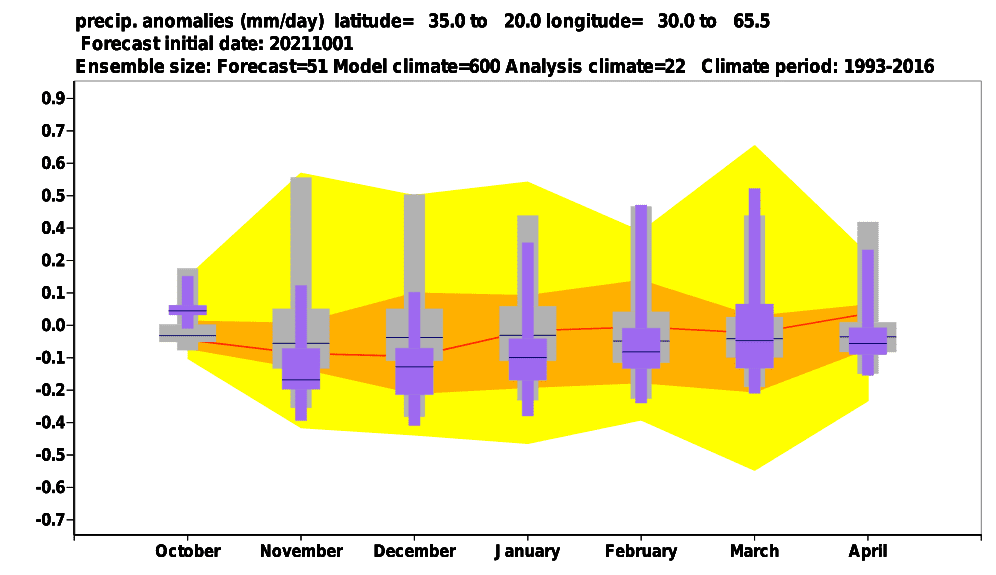
E) THE MIDDLE EAST: Hot and dry conditions will be leading in the region, mainly thanks to NAO+/AO+ phases in January and February. However, NAO-/AO- should bring a peak of winter in December and early January, with frosts and snow in northern parts (basins and valleys). In the second half of winter, however, tropical days above +30°C will be usual. Western disturbances and the Mediterranean lows are therefore more probable in the first half of the winter. A shift from negative to positive IOD and associated MJO phases should cause firstly hot and dry conditions in the southern Arabian Peninsula and later tropical activity, mainly in Oman and Yemen.
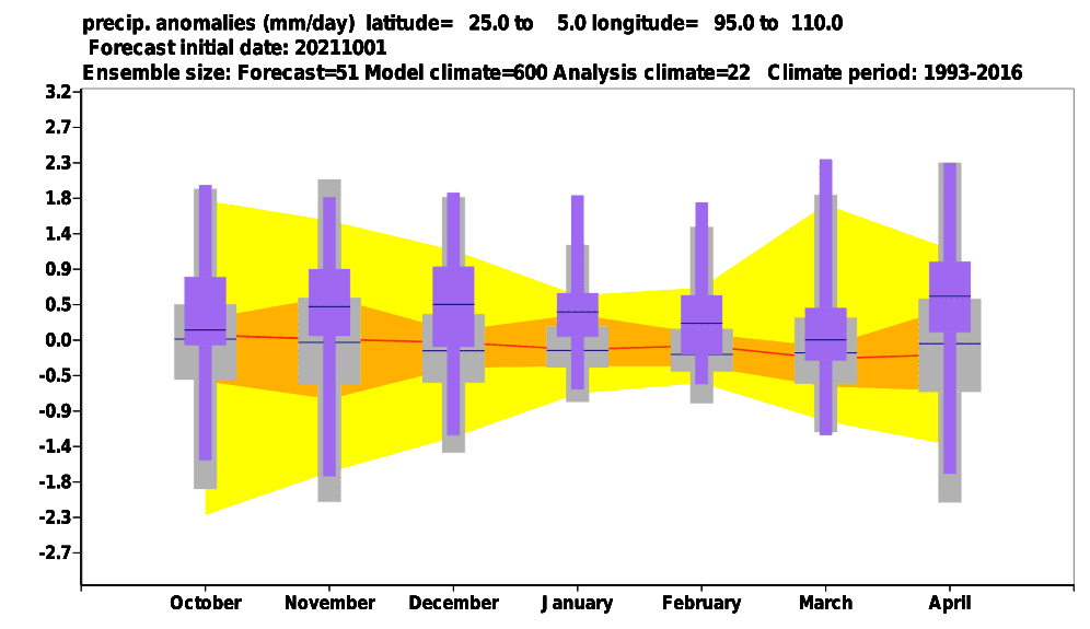
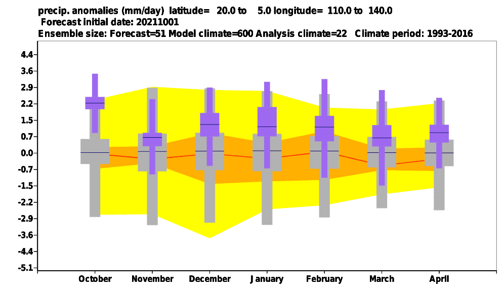
F) SOUTHERN AND SOUTHEASTERN MONSOON ASIA: La Nina, wet MJO, negative IOD combination means flooding and the stormy start of winter in Southeastern Asia and Eastern India. Only a possible weakening La Nina, drier MJO, and positive IOD should bring calmer conditions in mentioned regions in late winter, but tropical activity should shift above the western coast of India – Mumbai region should be stormy and cold. Cloudiness from storm systems in many regions brings warm nights and therefore higher average temperatures, rainfall will be important for harvest. Rare cooldowns in northern parts of the region in the first half of winter should be associated with AO-/NAO-. Temperatures around +25/+30°C will be usual in the region during the winter.
Before a cold December 2021 and early January 2022 period a long period of Indian summer in November 2021 in many parts of the Northern Hemisphere, is predicted /https://mkweather.com/november-should-start-with-summer-weather-record-temperatures-25c-in-continental-europe-are-possible/; http://mkweather.com/20c-in-northern-25c-in-southern-mid-latitudes-in-november-2021-untraditionally-late-indian-summer-for-northern-hemisphere-is-confirming//.
The last updates of the Winter 2021/2022 forecast we published here – and it really appears, that the upcoming winter will be probably peaking in Europe, Asia, and North Africa around December 2021 and early January 2022 and in North America around February 2022 (forecasts are still confirming): https://mkweather.com/winter-2021-2022-forecast-extreme-frosts-in-eurasia-in-december-in-north-america-in-february-early-canadian-stratospheric-warming-ne-pacific-blob-la-nina-qbo-and-shift-from-nao-to-nao-such-le/; https://mkweather.com/winter-2021-2022-forecast-a-peak-near-nao-already-in-december-ne-pacific-warm-blob-nao-and-early-spring-in-february-north-america-oppositely-warm-start-cold-end-of-winter/https://mkweather.com/mkweather-special-forecast-for-the-next-3-seasons-cold-autumn-2021-warmer-winter-2021-2022-cold-spring-2021-for-europe-a-peak-of-winter-in-its-colder-first-half-north-america-with-extreme-cold-2021-20/; https://mkweather.com/winter-2021-2022-forecast-the-first-reliable-estimates-extreme-cold-blasts-from-canada-and-western-siberia-snow-in-western-europe-and-eastern-asia-la-nina-qbo-to-qbo-shift-sufficient-nao-ao/ and we published ENSO outlook, too /https://mkweather.com/2022-2023-forecast-chances-for-el-nino//. It is also worth mentioning the Russian forecast for Siberia for Winter 2021/2022 (agree with our forecasts) /https://mkweather.com/russian-meteorologists-expect-extreme-winter-around-december-january-2021-22//.
Continental forecasts for Autumn (in Southern Hemisphere Spring) 2021 we published here: https://mkweather.com/autumn-2021-forecast-for-europe-mostly-dry-and-frosty-autumn-be-prepared-for-early-severe-frosts/; https://mkweather.com/autumn-2021-forecast-for-north-america-long-indian-summer-and-weaker-hurricane-season-such-as-expected/; https://mkweather.com/autumn-2021-forecast-for-asia-strong-monsoon-for-s-se-e-asia-hot-and-dry-in-the-middle-east-late-siberian-cold-blasts-in-w-siberia-and-snow-calamities-in-e-siberia/; https://mkweather.com/spring-autumn-forecast-for-africa-mostly-hot-and-dry-parts-of-sahel-equatorial-africa-stormy-and-south-africa-stormy-and-cold/; https://mkweather.com/spring-2021-forecast-for-australia-and-oceania-under-la-nina-rules-cold-and-stormy-australia-warm-new-zealand-and-various-patterns-in-oceania/; https://mkweather.com/spring-2021-forecast-for-south-america-floods-and-drought-in-many-regions/.
Mkweather until 30. November will be updating Winter 2021/2022 forecasts for Northern Hemisphere, yet, approximately 3-5 times, therefore stay watch weather with us and be prepared for possible early attacks of the winter.
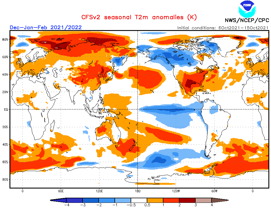
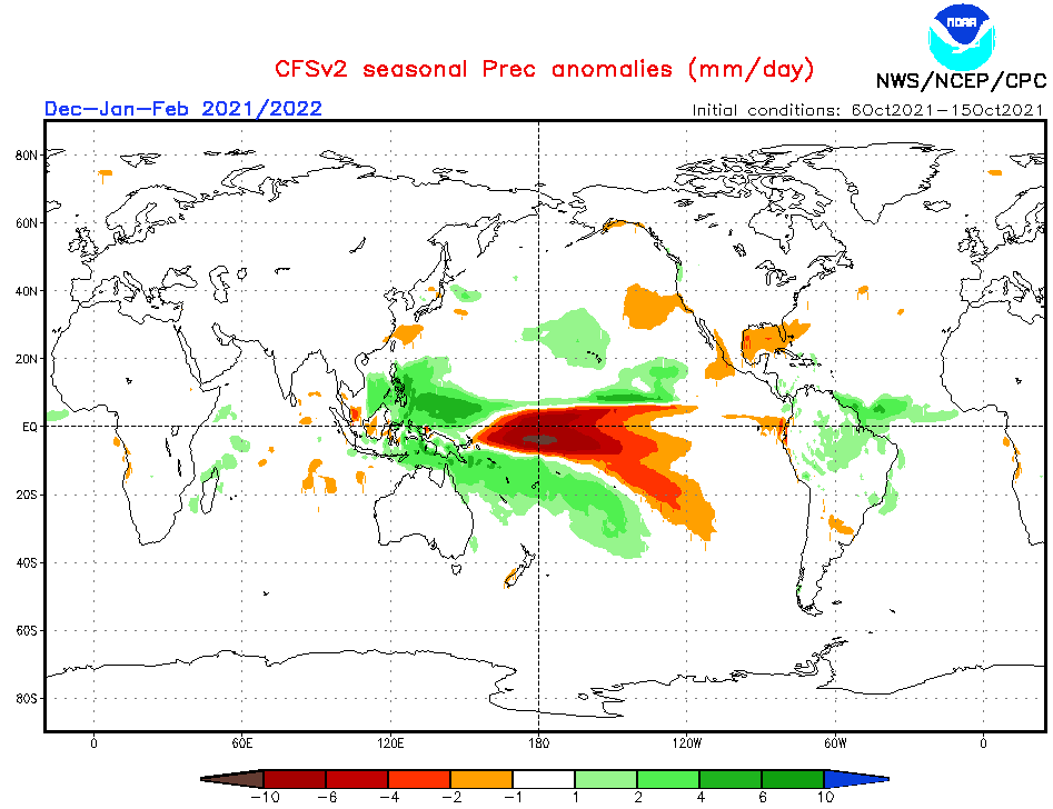
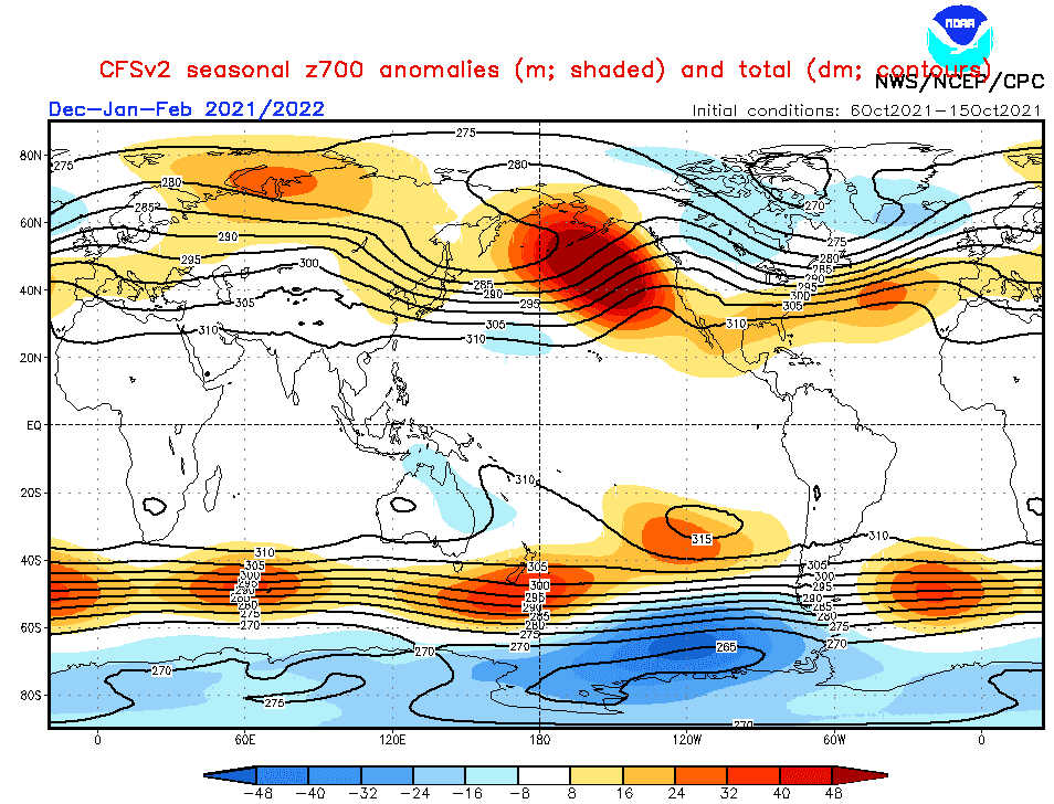
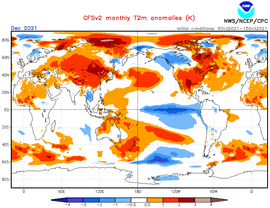
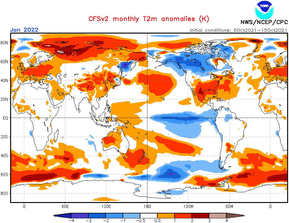
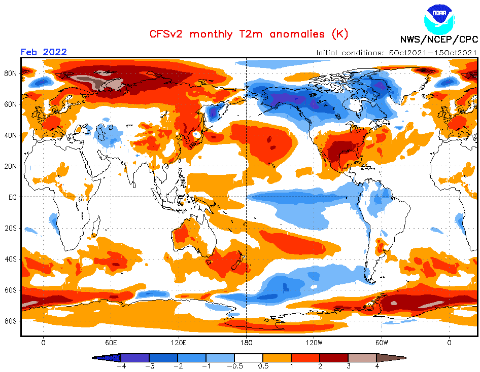
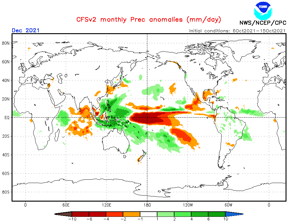
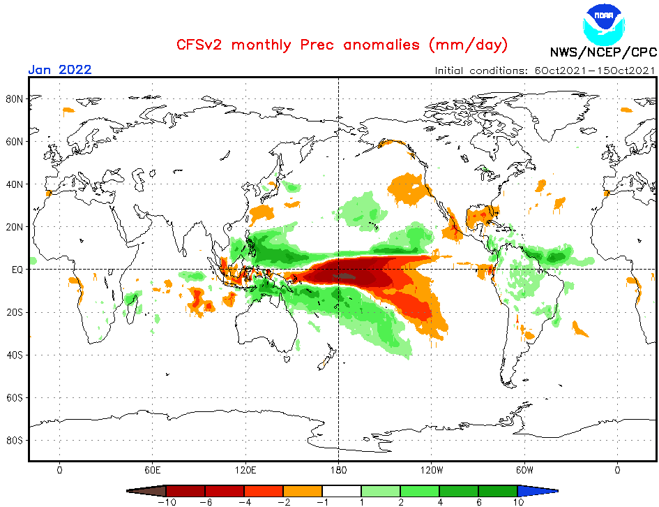
Source: https://www.cpc.ncep.noaa.gov/products/CFSv2/CFSv2_body.html
Source: https://iri.columbia.edu/our-expertise/climate/forecasts/enso/current/
Source: https://iri.columbia.edu/our-expertise/climate/forecasts/enso/current/
Source: https://iri.columbia.edu/our-expertise/climate/forecasts/enso/current/
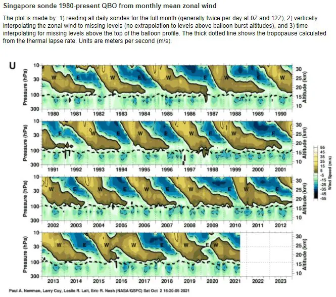
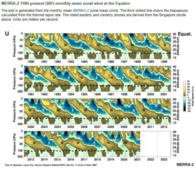
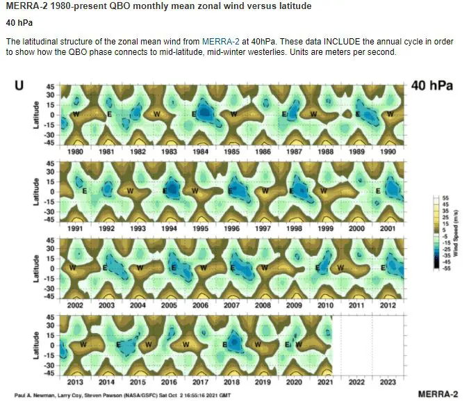
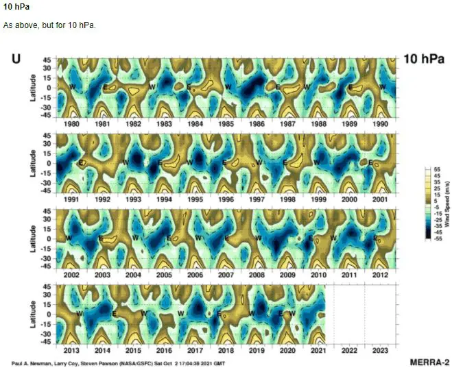
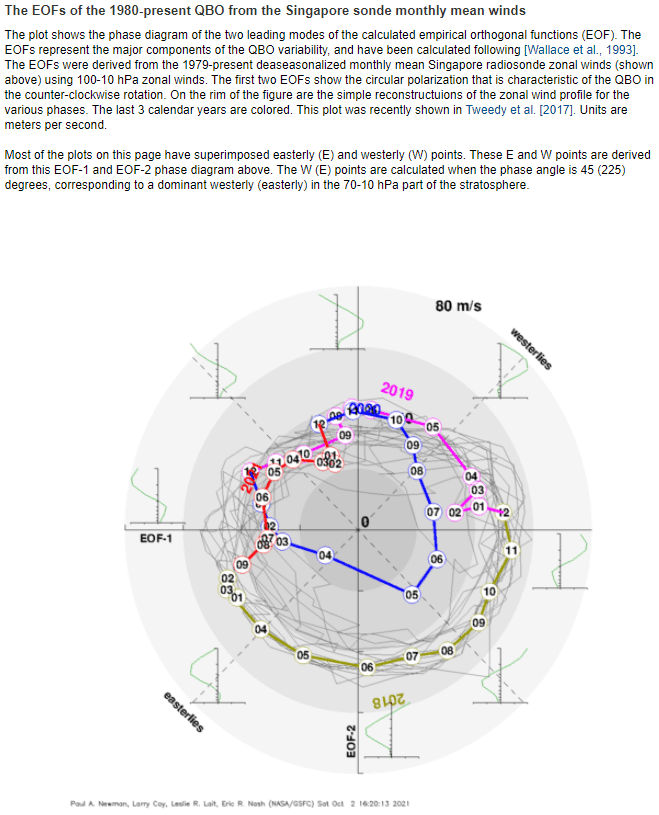
Source: https://acd-ext.gsfc.nasa.gov/Data_services/met/qbo/qbo.html

