Winter 2021/2022 is coming and we are bringing continental updates of predicted patterns for Europe, North America, Asia, Africa (Winter + Summer 2021/2022), Australia (Summer 2021/2022), and South America (Summer 2021/2022).
In the last articles, we looked at forecasted Winter 2021/2022 conditions in Europe /https://mkweather.com/winter-2021-2022-forecast-for-europe-early-extreme-arctic-and-siberian-blasts-and-blizzards-late-dry-and-very-warm-conditions// and North America /https://mkweather.com/winter-2021-2022-forecast-for-north-america-a-peak-of-winter-with-extreme-arctic-blasts-and-blizzards-in-february-2022//and Asia /https://mkweather.com/winter-2021-2022-forecast-for-asia-early-extreme-arctic-and-siberian-blasts-and-blizzards-late-dry-and-warm-conditions// and Summer 2021/2022 conditions in Australia and Oceania /https://mkweather.com/summer-2021-2022-forecast-for-australia-and-oceania-stormy-colder-la-nina-pattern-above-the-continent// and South America /http://mkweather.com/summer-2021-2022-forecast-for-south-america-stormy-north-hot-and-dry-south-cold-and-dry-pacific-coast//. Now we will look at Winter and Summer 2021/2022 in Africa.
The last update of the Winter forecast for the Northern Hemisphere we published here / https://mkweather.com/winter-2021-2022-forecast-extreme-frosts-in-eurasia-in-december-in-north-america-in-february-early-canadian-stratospheric-warming-ne-pacific-blob-la-nina-qbo-and-shift-from-nao-to-nao-such-le/ /.
10 main circulation patterns and important parameters will be affecting Africa during an upcoming winter/summer:
- Still low solar activity: We are still after a solar minimum, at the beginning of a 25. solar cycle, with a weaker predicted solar cycle. Weaker solar cycles were in the last centuries associated mainly with El-nino phases, but El-nino, maybe with a Godzilla character, is currently forecasted only for Autumn 2022 and years 2023, 2024 and maybe 2025 /https://mkweather.com/2022-2023-forecast-chances-for-el-nino//. Little Ice Age = low solar activity = El nino = NAO- and AO- and high solar activity /stronger sun cycles= La nina = NAO+ and AO+ in long-term perspective).
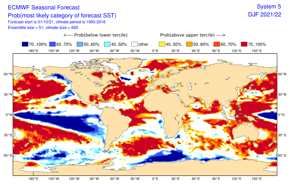
- Re-strengthening La Nina pattern: La nina in mostly years mean more fertile conditions for parts of Africa, however, in the next season, IOD and MJO will be probably more important, mainly for East and south-Central Africa /https://mkweather.com/2022-2023-forecast-chances-for-el-nino//. In the last year, La nina brought extremely warm conditions above Sahara, thanks to cold anomaly above Europe, which was shifting temporarily above northern African coast. In southern African states, La nina is associated with more stormy and reltively colder condtions troughouth the year. Unfortunately, drought and famines are possible in HOT/DRY regions despite of La nina during the next season.
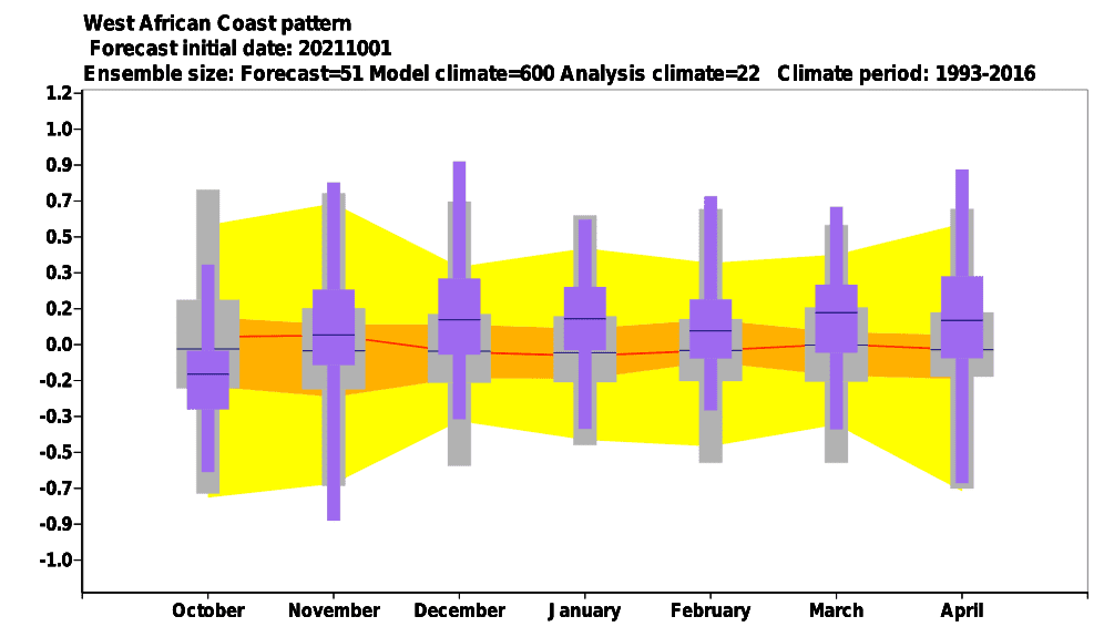
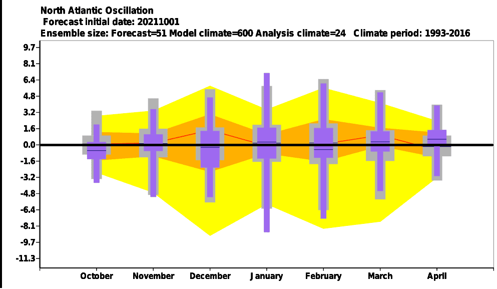
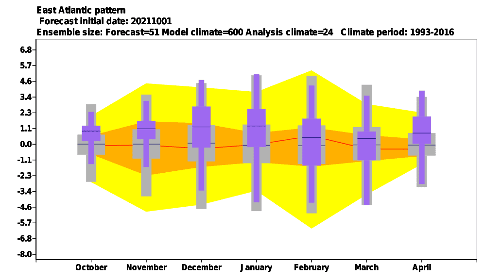
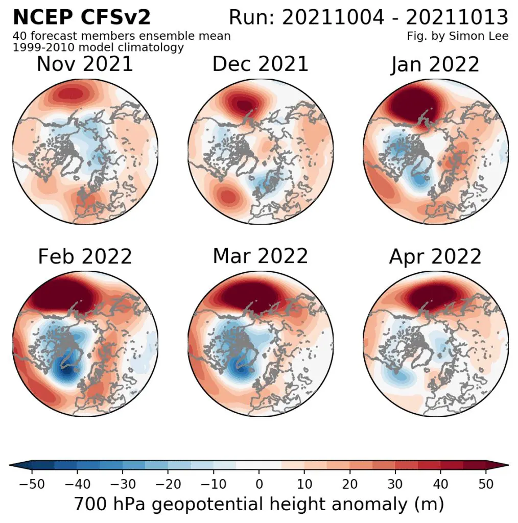
- Switch from NAO- / AO- to NAO+ / AO+ during Winter 2021/2022: The first half of Winter 2021, with dominant neutral or NAO- phases, should bring peak of the winter in north-African states, while the second half should be already mostly AO and NAO positive, with a belt of very dry and warm weather across mid-latitudes, however with regional colder nights in subtropical climate zone, including African Mediterranean. NAO- and AO- in the first half of winter should mean more stormy weather along north-African coast, with Mediterranean lows and snow and frosts in Atlas region. Rarely, snow should appear in metropolitan areas or deserts. The second half of winter shoulnd be near NAO+/AO+ farther from stormtrack of mid-latutidinal cyclones, with hot sunny days, but cold clear mornings (lesser cloudiness), with mostly neutral temperature effect according to ECMWF/CFS.
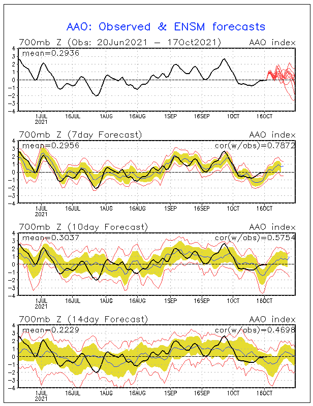
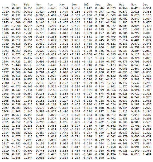
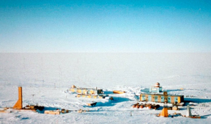
- AAO / SAM – Will bring Antarctic Oscillation positive phases and trend remains preserved? The South Pole experienced the coldest winter since records have begun /https://mkweather.com/the-south-pole-with-the-coldest-winter-in-history-average-temperature-april-september-half-year-only-610c// with anomalous temperatures even around 30. September 2021 /https://mkweather.com/vostok-794c-only-06c-from-the-all-time-october-record// thanks to positive phases of AAO / SAM (Antarctic Oscillation / Southern Annular Mode). After 2000, positive phases are more often throughout all year, including summer months (December, January, February). Despite of a possible farther stromtrack of Antarctic fronts from South Africa, the next important factor will be play in favor with relatively colder and stormier Summer 2021/2022 and this factor is Earth and mainly Southern Hemisphere-cooling La nina.
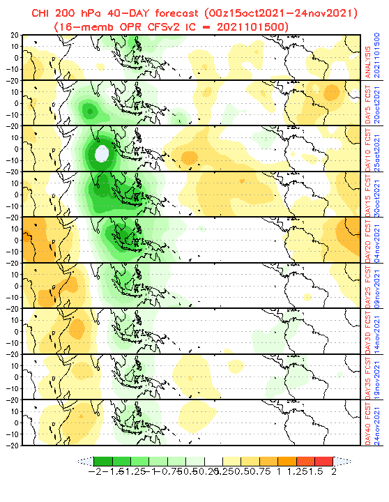
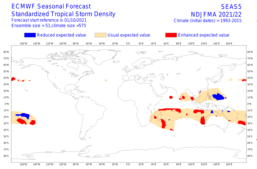
- IOD (Indian Ocean Dipole) shift from negative to positive phase: IOD is forecasted to shift from its negative to its positive phase during Winter 2021/2022, what means, that early winter should bring in eastern Indian Ocean region very stormy conditions, together with wet MJO and La nina, while western Indian Ocean will be anomalously hot and dry (East Africa). Positive IOD in late witner should be linked with calmer conditions, and weakening activity of tropical cyclones in eastern Indian Ocean (SE Asia, E India,…) and a shift of tropical activity into western Indian Ocean (including East Africa, Southeastern Africa, Madagascar, Mauritius…).
- Wet MJO above Southeastern Asia – Phases 4-7 correlate with NAO-/AO-: Anomalously stormy conditions above Southeastern Asia should persist mainly in the first half of Winter 2021/2022 – NAO- and AO- phases namely strongly correlate with MJO phases 4-7, phases, which are bringing extreme rainfall, floods and landslides into Southeastern Asia. It means, that above African tropical sector should be in the first half of summer lesser probability of tropical activity (cyclones and tropical storms). Situation should little change during MJO phases 8, 1-3 and the shift of NAO/AO to their positive phase in January and February 2022, with a shift of tropical moisture closer to African coast, with a possible severe cyclones from Somania to South Africa.
- QBO in Easterly phase: Although QBO is forecasted to stay in a colder phase until the end of Winter 2021/2022, other teleconnections will have probably a stronger impact on weather in Africa. This teleconnection however should contribute to relatively good potential for winter in many regions in the world.
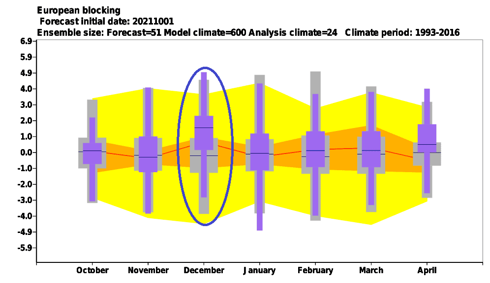
- Early Canadian Stratospheric Warming – Legendary December frosts not excluded: Around November, the Early Canadian Stratospheric Warming pattern is expected. This anomaly was in the past often associated with a subsequent NAO- / AO- around December and possible legendary winters in Eurasia, maybe during strong NAO-/AO- in North Africa /https://mkweather.com/russian-meteorologists-expect-extreme-winter-around-december-january-2021-22//.
- NE Pacific Warm Blob Anomaly – NAO+ regime for the second half of winter?: This anomaly above Northern Pacific correlates with NAO+ conditions. Both regimes are forecasted to persist in January and this circulation should be peaking around February 2022. Stronger NE Pacific Warm Blob therefore means a weakening of winter conditions in North Africa, but cold clear NAO+ nights.
- Major SSW (Major Sudden Stratospheric Warming) already in the first half of Winter 2021/2022: The last, very important factor is, if there are chances for so-called “destabilization of polar vortex”, strongly associated with AO- / NAO- phases across Northern Hemisphere and severe cold blasts in mid-latitudes. Yes! A probability of SSW will be here just during the first half of Winter 2021/2022. The collapse of polar vortex should become, with subsequent severe frosts firstly in European, Asian and North-African sectors. A response to a potantial collapse of polar vortex in Asia should bring an expected early peak of Winter 2021/2022 in Eurasia and North Africa.
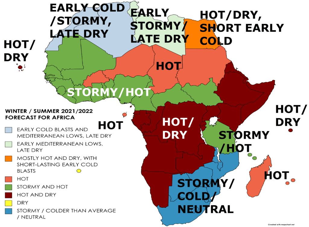
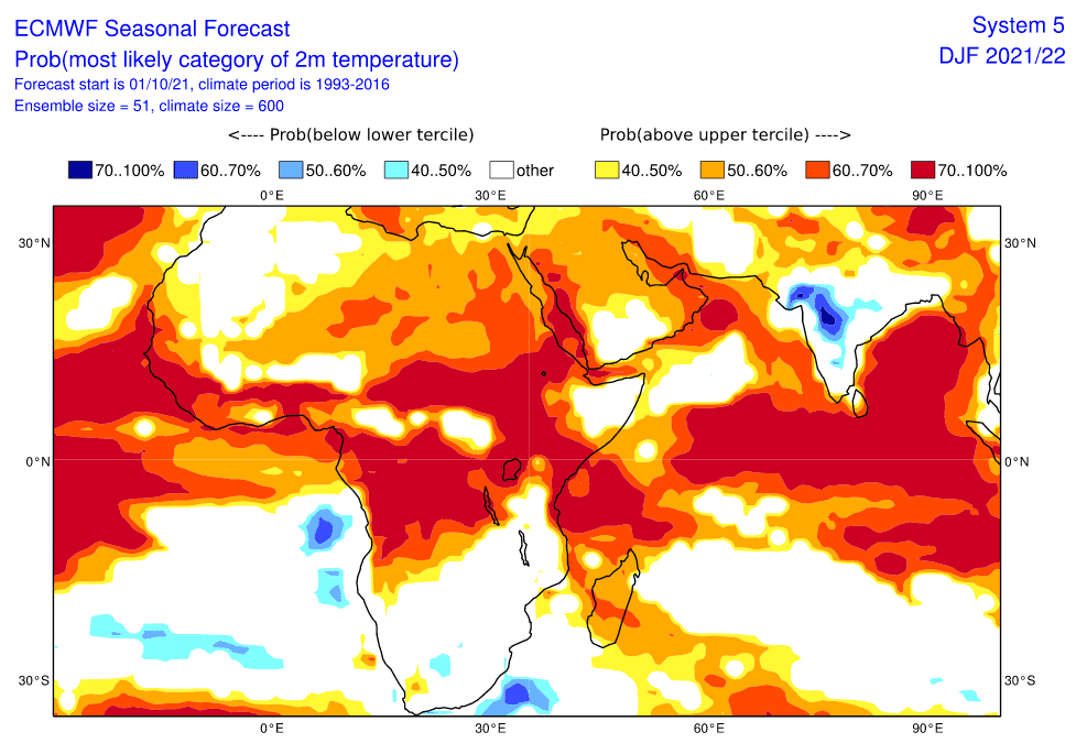
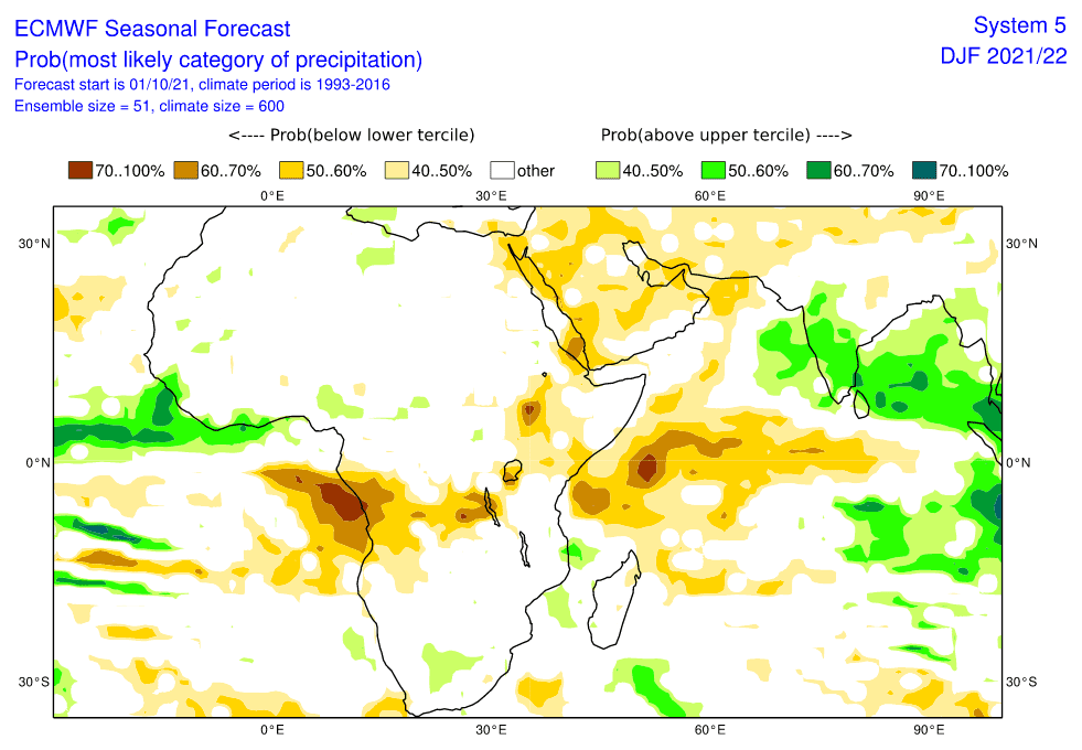
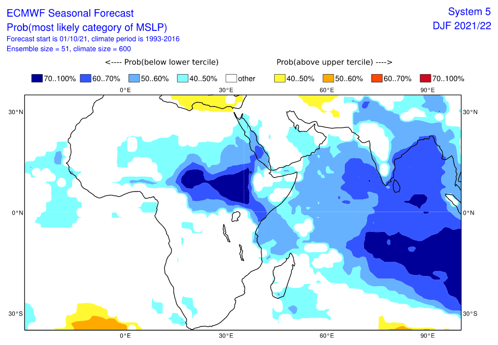
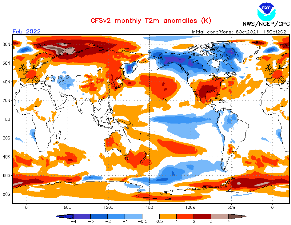
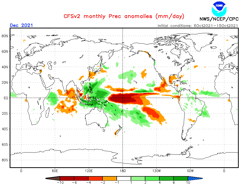
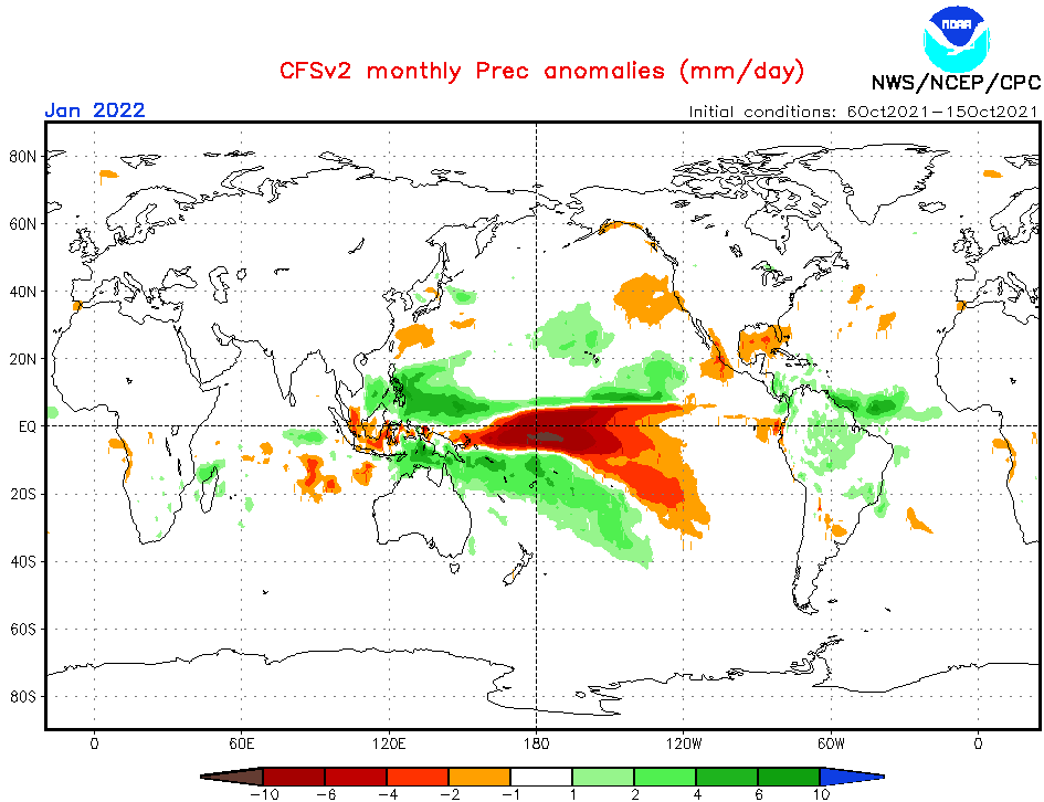
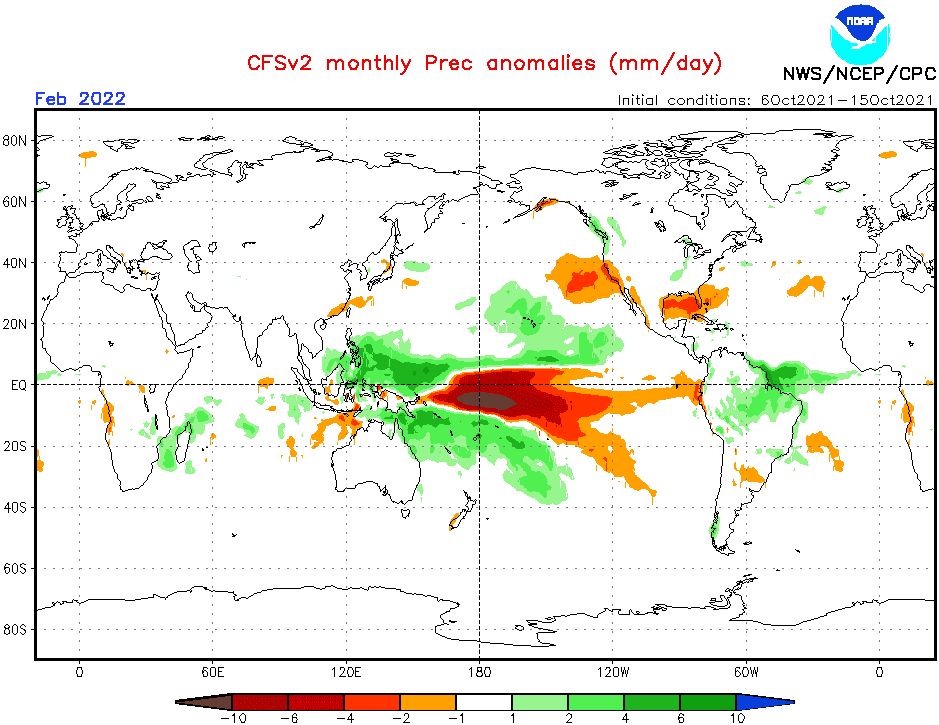
Now, we should look at a forecasted map for Winter 2021/2022 for Africa and 6 main sectors, with similar regimes of weather:
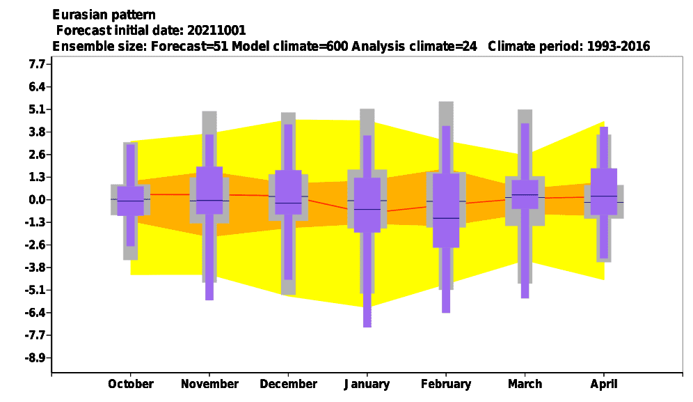
A) ALGERIA, MOROCCO, WESTERN SAHARA: Early NAO-/AO- phases should surprise with early Arctic cold blasts and blizzards from Mediterranean lows in the mountains. The second half of winter however should be very dry, with hot days, but cold NAO+ mornings. Peaking of winter around the end of December and early January is forecasted for Eurasia, too, there will be stocks of anomalously cold air, with a potential to shift above North Africa. Important will be the timing of a possible SSW, which should shift the peak of winter weeks earlier or later than was expected. NE Pacific Warm Blob however strongly correlates with NAO+ and the second half of winter should be already farther from the polar and arctic front in the region. Temperatures up to -10°C and snow should appear in the first half of winter in frost valleys below 1000 MASL, while the second half of winter (the first half, too, but with lesser frequency) should surprise with +30°C temperatures not only above Sahara.
B) TUNISIA, LIBYA: More Mediterranean lows mainly in the first half of Winter 2021/2022 should mean an overall wet anomaly above the region. Frosts won´t be so strong such as in NW Africa, but temperatures during the peak of winter should drop below 0°C with rare snowing. The second half of winter should be dry, with hot days and cold nights (NAO+ regime). Libya should be warmer, mainly eastern parts. Mediterranean lows should bring local flash floods, hailstorms, or even rare tornadoes in early winter during NAO- phases.
C) EGYPT: Only weaker shots of winter in its first half, with rare frosts or snowing during the peaking and mostly hot and dry weather, in southern parts +30/+35°C, with holiday weather, is forecasted. A dry and warm anomaly is predicted for the winter and Egypt should become the warmest north-African country in the winter. Conditions in comparison with Summer 2021 therefore will be swapped and colder will be western and hotter eastern Sahara (and the Sahel).
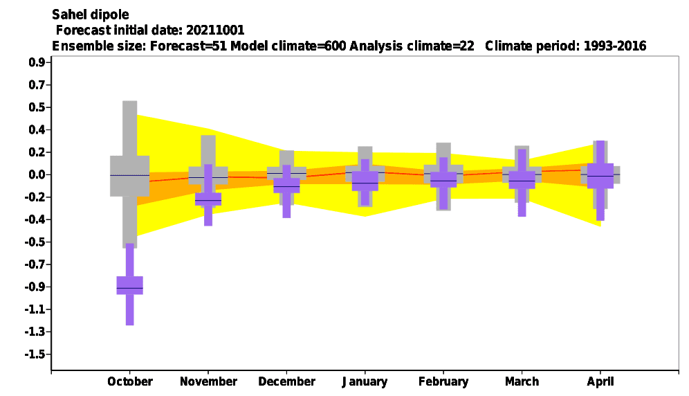
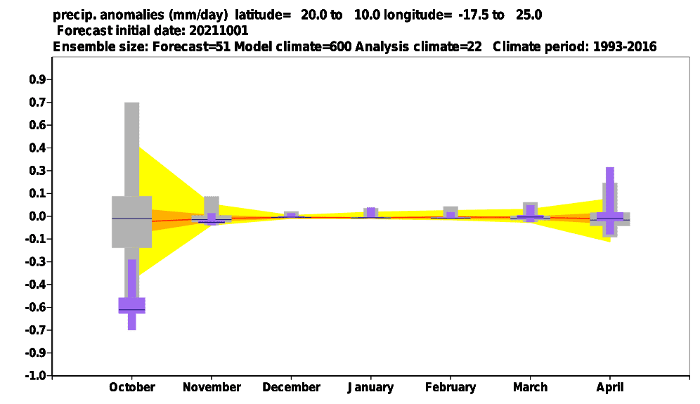
D) EASTERN AND CENTRAL SAHEL, MADAGASCAR, MAURITIUS, REUNION: Hot conditions and season of drought are forecasted for Eastern and Central Sahel. Season of drought should come prematurely – Sahel indices are saying about premature drought in October and November in the region, without floods, but with a possible regional food crisis. Tropical temperatures above +35°C will be possible, and during a possible Major SSW in the first half of winter, mainly around late December and early January, cold shots from the north are possible, however, with minimum temperatures above 0°C and relatively colder days. Madagascar, Mauritius, and Reunion should be hotter thanks to the negative IOD phase in December (and early January), which should dominate above a positive phase in February (and late January). However, in all eastern and southeastern Africa, increased activity of cyclones is overall in the next half-year forecasted, therefore, the second half of winter should bring a dramatic change and strong tropical activity.
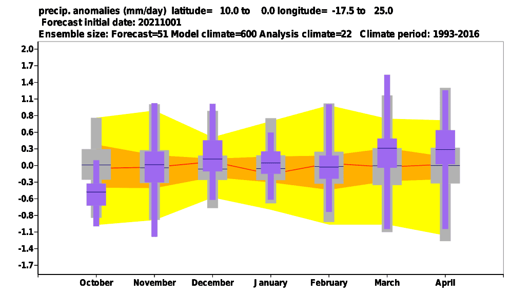
E) WEST AFRICA, WESTERN SAHEL, CENTRAL EQUATORIAL AFRICA, TANZANIA: Stormy and hot pattern for West Africa, Western Sahel, Central Equatorial Africa, and Tanzania should be linked mainly with La Nina, MJO, and IOD conditions. Season of rains should be stronger, with many floods and landslides, humidex should be high, with increased amounts of collapses from the heat. West African patterns promise stormy patterns, too. Tanzania should be hit by a stronger cyclone season mainly in the second half of summer.
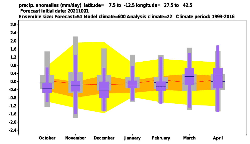
F) EAST AFRICA, SOUTH-CENTRAL AFRICA, NAMIBIA, ANGOLA, CABO VERDE: Hot and dry regions of East Africa, Congos, Angola, or Namibia are telling above dry IOD and MJO conditions in early summer, such as lack of impact of La Nina in the upcoming season. This circulation pattern should be associated with a persisting drought, wildfires or even, regional famines, lack of water, and food. The second half of winter, with a positive IOD and wet MJO near the African coast, should be “better”, with some tropical cyclones in Somalia or Kenya.
G) ST. HELENA: Dry anomaly was detected.
H) SOUTH-AFRICAN REGION: La Nina and a shift from negative to positive IOD, such as a possible AAO+ should be leading patterns in the region during the upcoming summer, with a result of neutral or regionally colder, and mainly stormy Summer 2021/2022. Storms should bring gusting winds, heavy rainfall, hail, damaging lighting, or tornadoes, and mainly in the second half of the season, the strong activity of Indian cyclones is near positive IOD possible. Temperatures during heatwaves however should reaching almost +50°C in deserts and +40°C along the coast and in higher elevated, still populated areas.
The last updates of the Winter 2021/2022 forecast we published here – and it really appears, that the upcoming winter will be probably peaking in Europe, Asia, and North Africa around December 2021 and early January 2022 and in North America around February 2022 (forecasts are still confirming): https://mkweather.com/winter-2021-2022-forecast-extreme-frosts-in-eurasia-in-december-in-north-america-in-february-early-canadian-stratospheric-warming-ne-pacific-blob-la-nina-qbo-and-shift-from-nao-to-nao-such-le/; https://mkweather.com/winter-2021-2022-forecast-a-peak-near-nao-already-in-december-ne-pacific-warm-blob-nao-and-early-spring-in-february-north-america-oppositely-warm-start-cold-end-of-winter/https://mkweather.com/mkweather-special-forecast-for-the-next-3-seasons-cold-autumn-2021-warmer-winter-2021-2022-cold-spring-2021-for-europe-a-peak-of-winter-in-its-colder-first-half-north-america-with-extreme-cold-2021-20/; https://mkweather.com/winter-2021-2022-forecast-the-first-reliable-estimates-extreme-cold-blasts-from-canada-and-western-siberia-snow-in-western-europe-and-eastern-asia-la-nina-qbo-to-qbo-shift-sufficient-nao-ao/ and we published ENSO outlook, too /https://mkweather.com/2022-2023-forecast-chances-for-el-nino//. It is also worth mentioning the Russian forecast for Siberia for Winter 2021/2022 (agree with our forecasts) /https://mkweather.com/russian-meteorologists-expect-extreme-winter-around-december-january-2021-22//.
Continental forecasts for Autumn (in Southern Hemisphere Spring) 2021 we published here: https://mkweather.com/autumn-2021-forecast-for-europe-mostly-dry-and-frosty-autumn-be-prepared-for-early-severe-frosts/; https://mkweather.com/autumn-2021-forecast-for-north-america-long-indian-summer-and-weaker-hurricane-season-such-as-expected/; https://mkweather.com/autumn-2021-forecast-for-asia-strong-monsoon-for-s-se-e-asia-hot-and-dry-in-the-middle-east-late-siberian-cold-blasts-in-w-siberia-and-snow-calamities-in-e-siberia/; https://mkweather.com/spring-autumn-forecast-for-africa-mostly-hot-and-dry-parts-of-sahel-equatorial-africa-stormy-and-south-africa-stormy-and-cold/; https://mkweather.com/spring-2021-forecast-for-australia-and-oceania-under-la-nina-rules-cold-and-stormy-australia-warm-new-zealand-and-various-patterns-in-oceania/; https://mkweather.com/spring-2021-forecast-for-south-america-floods-and-drought-in-many-regions/.
Mkweather until 30. November will be updating Winter 2021/2022 forecasts for Northern Hemisphere, yet, approximately 3-5 times, therefore stay watch weather with us and be prepared for possible early attacks of the winter and Mediterranean lows in North Africa. Be careful and watch storm forecasts in South African countries, during the upcoming Summer 2021/2022, too and stay safe in other regions, near severe storms in Equatorial/Western Africa or severe drought in Eastern or South-Central Africa.
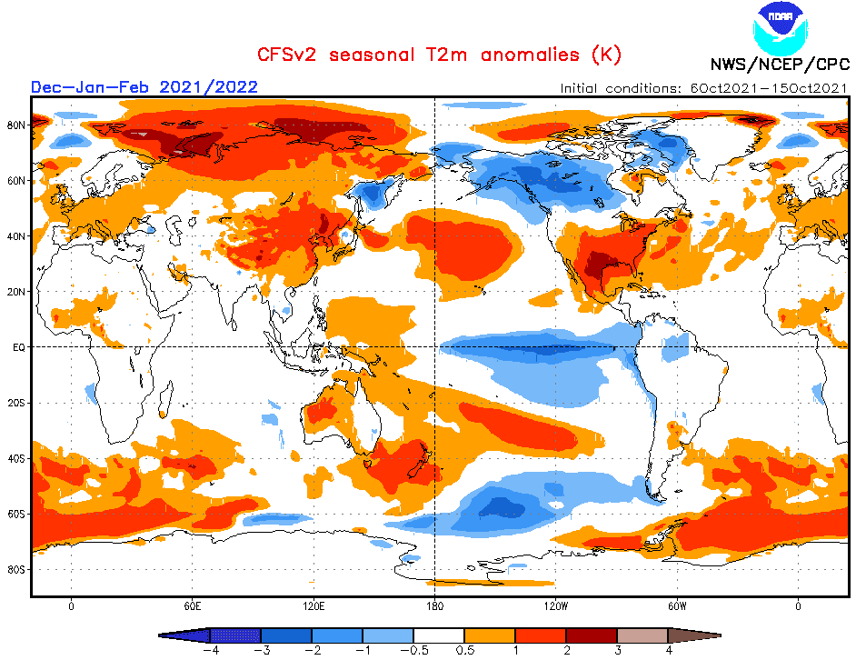
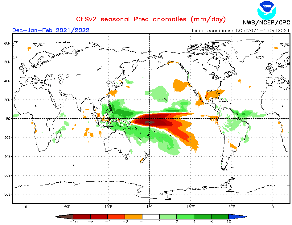
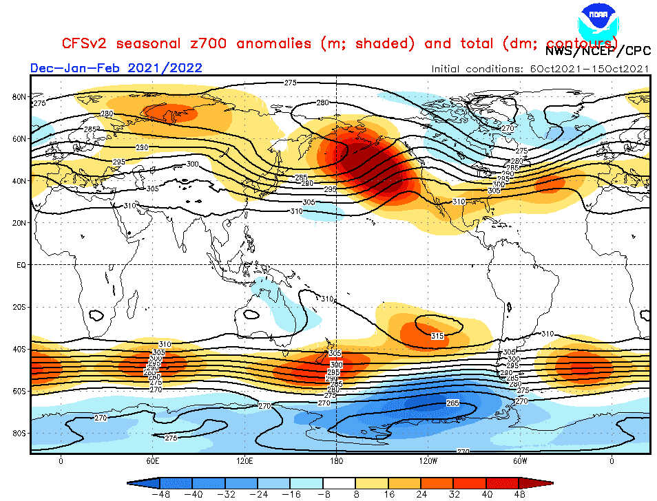
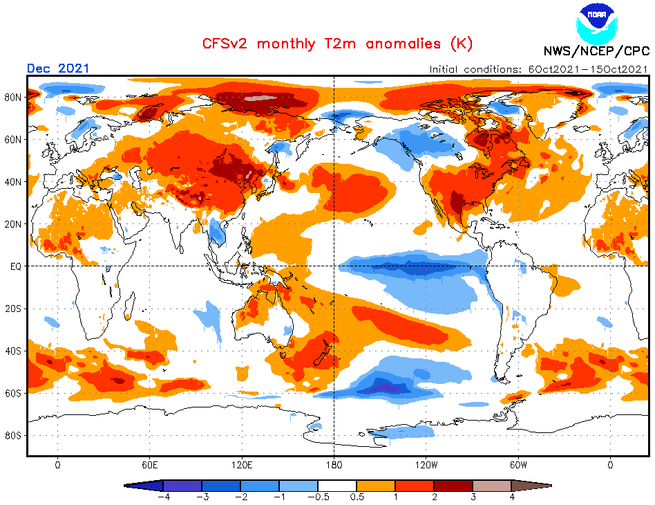
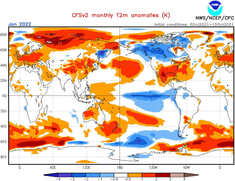
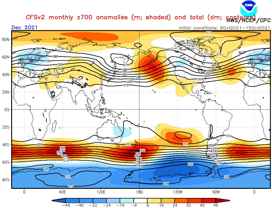
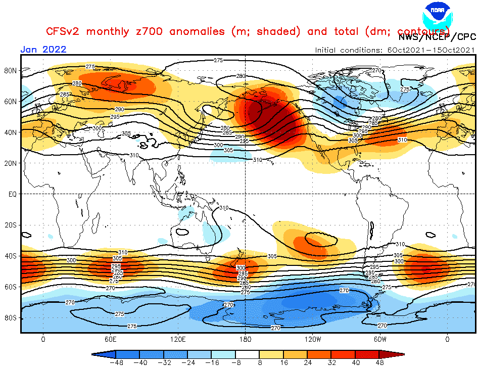
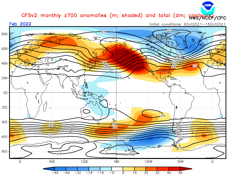
Source: https://www.cpc.ncep.noaa.gov/products/CFSv2/CFSv2_body.html
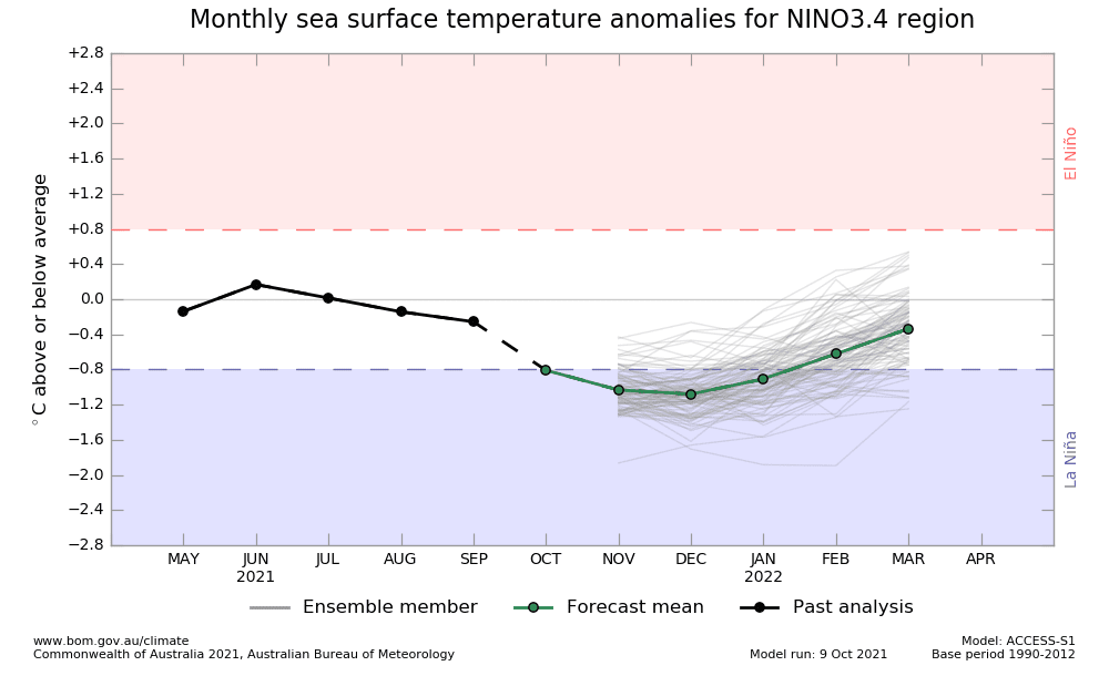
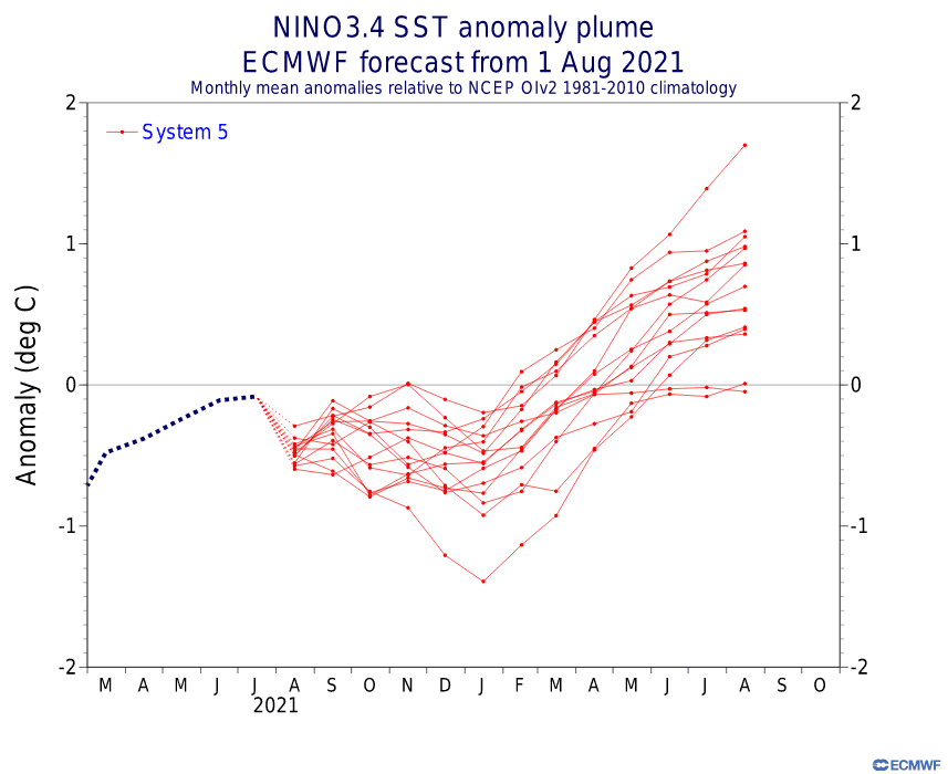
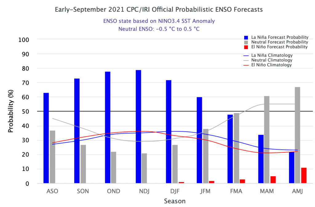
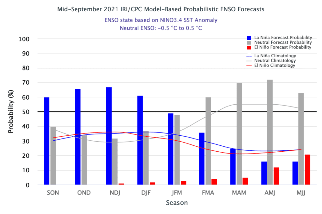
Source: https://iri.columbia.edu/our-expertise/climate/forecasts/enso/current/
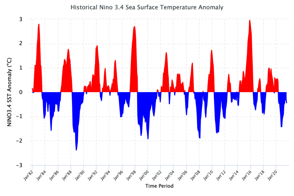
Source: https://iri.columbia.edu/our-expertise/climate/forecasts/enso/current/
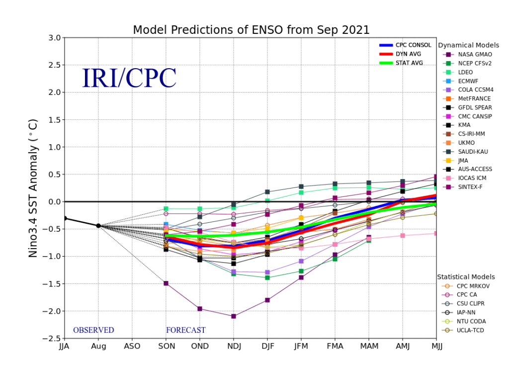
Source: https://iri.columbia.edu/our-expertise/climate/forecasts/enso/current/
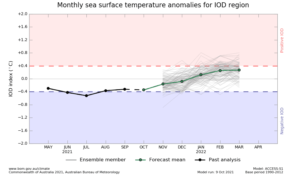
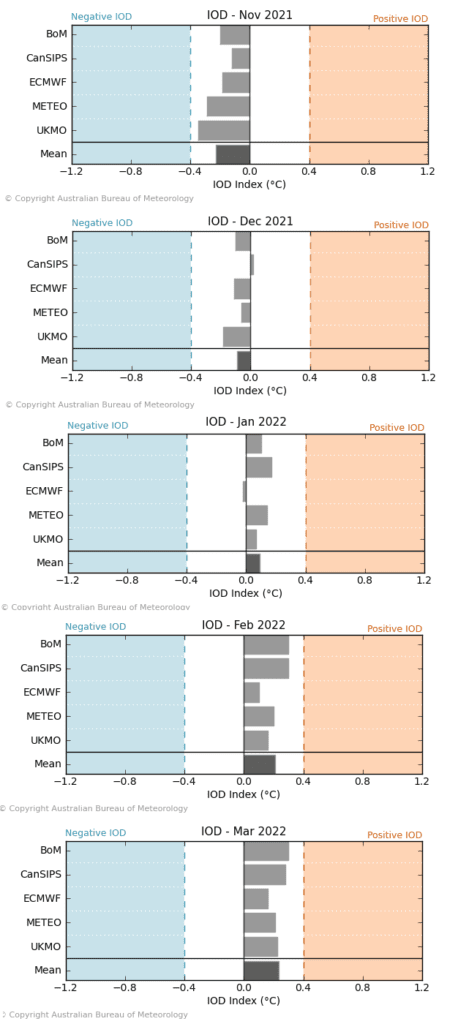
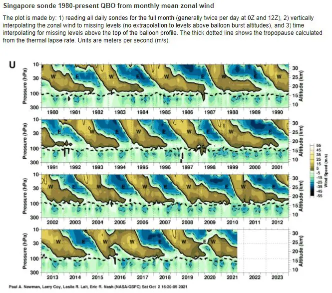
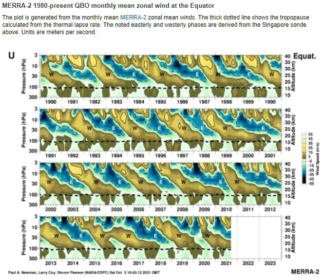
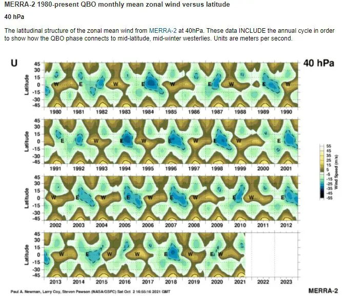
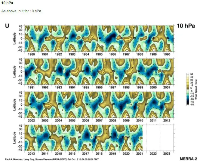
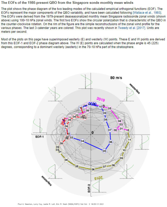
Source: https://acd-ext.gsfc.nasa.gov/Data_services/met/qbo/qbo.html
