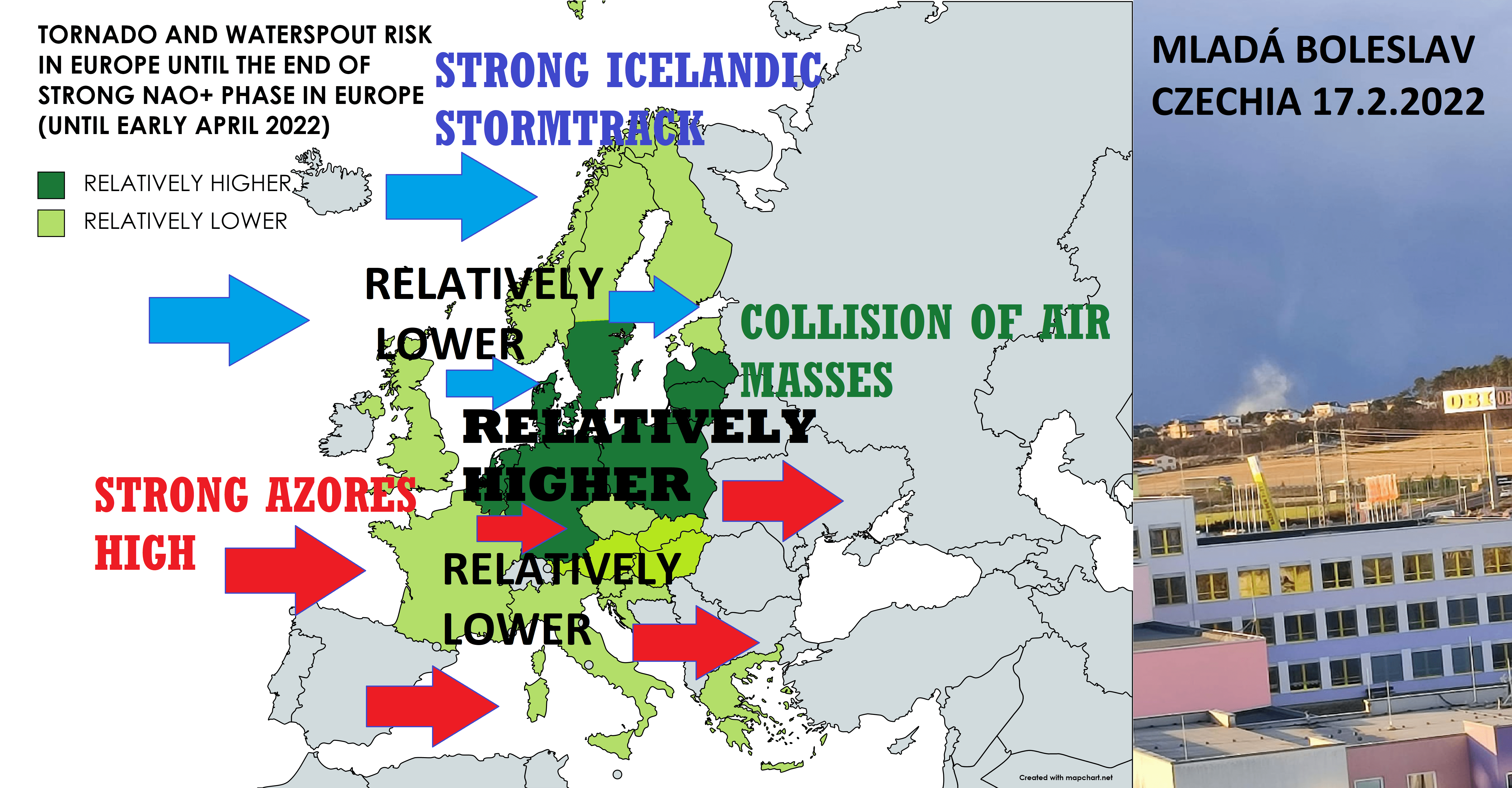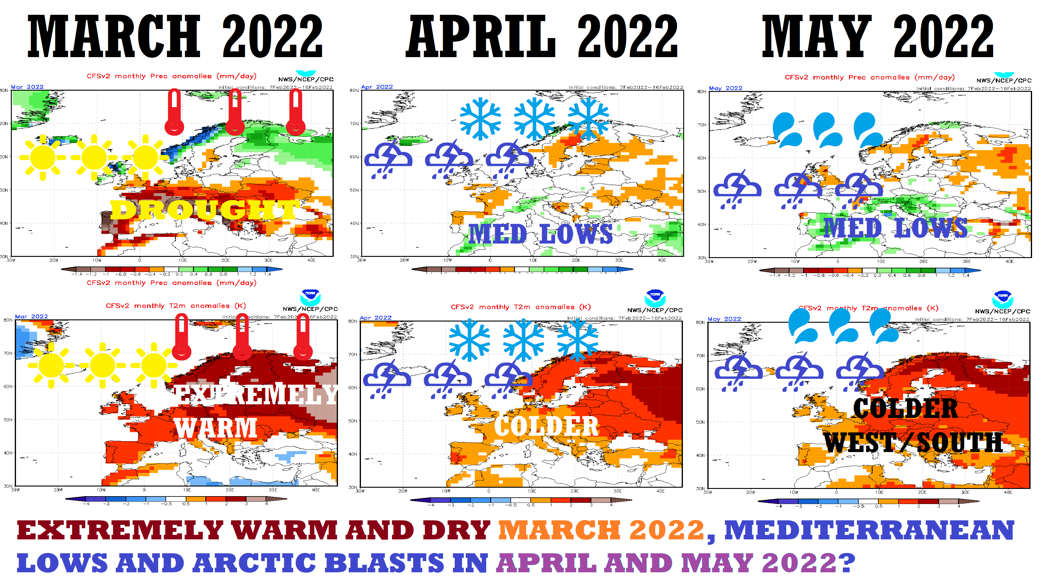
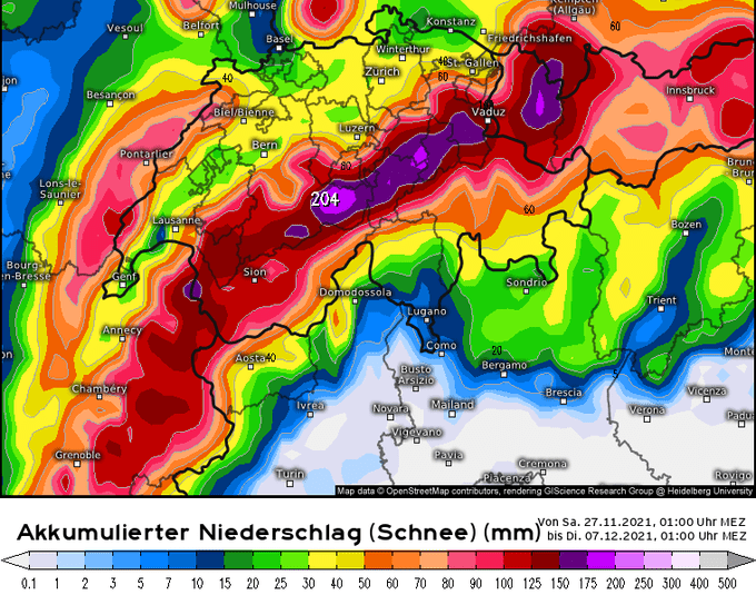
Linthal, Switzerland (800 MASL) with 0,5 meters of snow! Koetzchach (700 MASL), Austria 40 cm, next 3 days will come the next snowfall!
After a 50-year temperature record in Scandinavia (-37,5°C in Nikkaluokta, Sweden on 29. November 2021: https://mkweather.com/brutally-cold-weather-in-scandinavia-legendary-frosts-in-sweden-375c-norway-369c-and-finland-340c-and-below-40c-is-forecasted-the-coldest-seasonal-temperatures-in-50/) and a 50-year record in France (-10,0°C in Grenoble, southern France on 30. November 2021: https://mkweather.com/grenoble-france-384-masl-100c-the-coldest-temperatures-in-the-region-minimally-in-the-last-50-years/), the next extreme record from continental Europe!
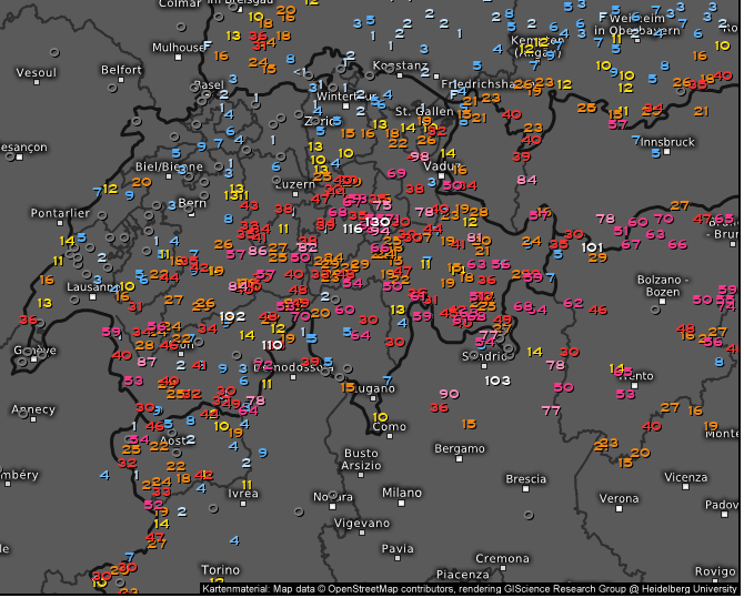
While in warm and cold fronts already have shifted above Central Europe from Switzerland eastward, and is bringing blizzard conditions from Eastern France to Ukraine /https://mkweather.com/europe-hit-severe-snowstorm-10-30-rarely-up-to-50-cm-of-snow-is-reported-from-eastern-france-central-europe-baltic-region-and-balkan//, Swiss basins and valleys around 500 – 1000 MASL already have received extreme snowfall amounts!
Linthal, a village in canton Glarus in Switzerland, 650 MASL, according to DWD and Meteo Schweiz reports almost 0,5 meters of snow from the blizzard in elevations only around 800 MASL!
49 cm of snow was reported from the village on 30. November 2021 and until Friday, 3. December 2021, the next severe snowfall is forecasted!
Meanwhile, Koetzchach, Austria, 709MASL, reported on 30. November, evening, 38 cm /https://ogimet.com/cgi-bin/gsynres?state=Austri&osum=no&fmt=html&ord=REV&ano=2021&mes=11&day=30&hora=22&ndays=1&Enviar=Ver/.
Total snow cover in the region will very probably stop between 50 – 100 cm in the next days, or in a longer period until 10. December 2021 (after 10.12. warming up is already forecasted).
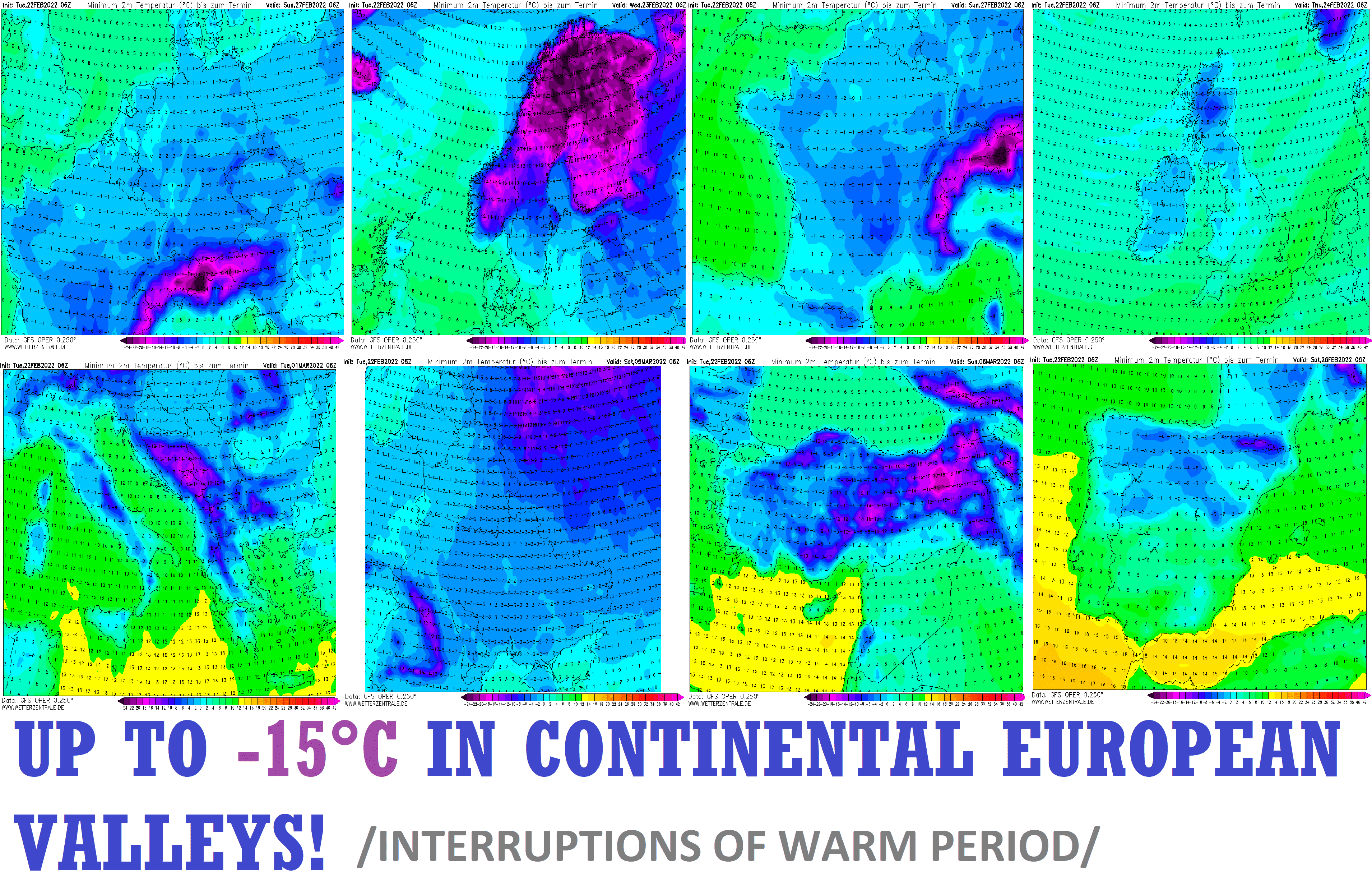
Alpine densely populated basins and valleys below 1000 MASL are therefore fully prepared for possible extreme frosts in the first December 2021 decade.
The temperature on a deep snow cover should fall in these valleys below -20°C, -25°C, or maybe even -30°C!
We are still waiting for a confirmation of extremely cold outputs, in which historically cold air from Scandinavia will flood Central Europe in the next 10 days.
-20°C is somewhere in Central Europe is very probable, -25°C probable, and -30°C is not fully excluded so far, mainly near heavy snowfall, weak winds, and anomalously dry air combinations.
The situation in Europe we will furthermore watch and will be bringing fresh news about measured weather records and updates of forecasts.
Blick zum Nachbarn: Frühwinter in der #Schweiz /kis https://t.co/cmfpjHSPXW
— DWD (@DWD_presse) November 29, 2021
#Schweiz: Nach dem neuen #ECMWF-Modell ist entlang der Alpen von den Walliser Alpen bis zum Alpstein binnen der kommenden 10 Tage mit großen #Schnee-Mengen auf den Bergen zu rechnen. Für Details in die Kantone/Bezirke. https://t.co/sSqrOtU40u /CG
— Alpinwetter | kachelmannwetter.com (@Alpinwetter) November 27, 2021
„Winter Wonderland“ hat in der Schweiz eine andere Bedeutung. Es ist nicht einmal Dezember und der Schnee ist 40cm hoch. Trotzdem sieht es hier herrlich aus. pic.twitter.com/0jOiaGQqOP
— Nhung (@Oliviamai_re) November 30, 2021
Manchmal habe ich das Gefühl, die Schweiz liegt in der Tropenzone und wird jede Jahr absolut unerwartet vom Schnee überrascht: https://t.co/zHyfT92uCN
— Sacha B. 💉💉💉 (@SachaBundy) November 29, 2021
Moinsen von einem kleinen Berg in der Schweiz 😃❄️😃❄️😃❄️#schweiz #schnee #winter pic.twitter.com/RTlU6Xrf94
— Miss Eve (@MissEve2002) November 29, 2021
#Schweiz: Hier ein Überblick über die #Schnee-Höhen von heute in der Früh. Nachts hat sich auch im Appenzellerland eine Schneedecke gebildet. In Appenzell liegen jetzt 5 cm. Zum Ablesen in die Kantone/Bezirke. https://t.co/UbrotakXYj /CG
— Alpinwetter | kachelmannwetter.com (@Alpinwetter) November 28, 2021